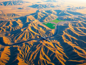
Innovative imaging techniques are transforming surveying practices, providing a new level of detail and accuracy. Utilizing advanced technology, professionals can create meticulous maps while capturing the landscape from unique perspectives.
Drones fitted with high-resolution cameras enable swift image acquisition across expansive regions.
Through the process of photogrammetry, these visuals are converted into intricate topographic representations.
The speed of aerial surveys dramatically streamlines data collection, leading to faster project completions. As advancements continue, the incorporation of artificial intelligence promises to enhance these methods further, establishing new benchmarks for mapping reliability in the industry.
Understanding Aerial Surveying Techniques
This innovative approach enables data collection from unique perspectives, offering valuable insights across diverse terrains. The technique significantly enhances geographic information systems through accurate measurements and comprehensive mapping.
Various methods, including photogrammetry and LiDAR, utilize cutting-edge technology to convert images into useful information.
Each technique presents distinct advantages, influencing sectors such as construction, environmental management, and urban planning.
Capturing information from above facilitates improved decision-making processes and supports effective resource management while addressing factors like weather conditions and regulatory compliance.

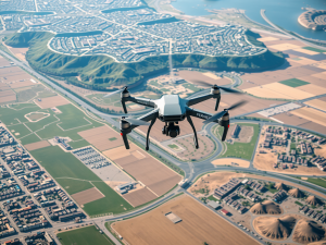
The Role Of Drones In Modern Mapping
Precision has become increasingly important, and the emergence of innovative technology allows for significant advancements in mapping practices. These aerial devices can capture vast areas from a unique altitude, enabling rapid data collection.
Unlike conventional methods, the use of drones significantly reduces the time required for an aerial survey.
The enhanced image resolution achieved through this approach offers a level of detail previously unattainable.
As industries embrace photogrammetry techniques, the demand for accurate environmental monitoring and analysis rises. Drones are revolutionizing how we engage with and interpret the Earth’s features.
| Advantage | Traditional Methods |
|---|---|
| Faster data collection | Slower survey times |
| Higher image resolution | Lower detail levels |
| Broader area coverage | Limited geographic reach |
| Increased demand for accuracy | Less focus on precision |
Benefits Of High Resolution Aerial Photography
Capturing landscapes from an elevated perspective offers unmatched insights into our environment. Superior detail is one notable advantage, enabling clear visual representations that enhance the understanding of intricate features.
With a drone equipped with an aerial camera, users can gather images that reveal important information about land use, vegetation, and topography.
This increased clarity not only supports effective decision-making but also contributes to improved precision in mapping applications.
The combination of rapid data collection and elevation insights accelerates project timelines, making aerial images an invaluable asset across various industries. As we transition from discussing the role of drones in modern mapping, it’s clear that efficient data collection using UAVs is integral to harnessing these benefits.
Effective Data Collection Using UAVs
Innovations in aerial technology have transformed approaches to gathering information across diverse sectors.
Equipped with sophisticated sensors, unmanned aerial vehicles can cover vast areas in a fraction of the time it would take traditional surveyors.
This efficiency not only reduces labor costs but also enhances the overall accuracy of the gathered information.
For instance, when monitoring urban planning, drones can capture a bird’s eye view, providing invaluable insights into topographic changes and land use.
As these technologies evolve, the integration of control points will further refine data collection processes, ensuring precision and reliability
Aerial Technology Innovations
- Unmanned aerial vehicles can cover large areas much faster than traditional survey methods.
- The use of drones significantly reduces labor costs associated with data collection.
- Drones provide a comprehensive view of urban planning, revealing important topographic and land use changes.
- Integration of control points in drone technology improves the precision and reliability of data collected.
Exploring Photogrammetry For Accurate Topography
Accurate topographic mapping relies on sophisticated techniques that enable the transformation of visual data into meaningful representations of the earth’s surface. Utilizing aerial photographs, this methodology captures intricate details crucial for effective mapping.
The process involves various strategies to convert imagery into quantitative data, allowing for a precise representation of landscapes.
Aerial surveying often requires meticulous analysis of data to ensure high levels of accuracy.
This technology plays a significant role in diverse sectors, such as construction and agriculture. With its basis in advanced remote sensing methods, this approach enhances our comprehension of terrain dynamics.
As we delve deeper into this innovative sphere, the significance of environmental monitoring becomes more pronounced, prompting us to consider how weather conditions influence the efficacy of aerial surveys.
Weather Considerations For Aerial Surveys
Successful aerial surveys rely heavily on environmental conditions, which can greatly influence operational efficiency. The presence of dense cloud cover and reduced visibility can compromise the precision of data collected during flights.
When high-resolution images are needed, capturing photographs under overcast skies becomes increasingly difficult.
Wind speed significantly affects the stability of manned aircraft, particularly when using helicopters or fixed-wing aircraft.
It is important to monitor weather patterns ahead of time, allowing surveyors to select the best conditions for optimal data gathering.
Aerial Surveys
- Dense cloud cover can significantly reduce the quality of aerial imagery.
- High-resolution data collection is more challenging under overcast conditions.
- Wind speed impacts the stability and safety of manned aircraft during surveys.
- Monitoring weather patterns allows for better planning and data collection efficiency.
Elevation Mapping Using Aerial Images
The ability to accurately analyze topographical features has transformed techniques in environmental representation. Gathering precise data about a piece of land has improved significantly with the introduction of innovative technology.
Aerial photos captured from varying perspectives deliver insights that traditional approaches often overlook.
The combination of digital cameras and lidar systems plays a pivotal role in constructing detailed 2D or 3D models of the landscape.
Equipment used in this endeavor, including drones, facilitates rapid data acquisition by enabling the capturing of high-resolution images. This advancement not only streamlines the mapping process but also enhances the reliability of geospatial data, making elevation analysis increasingly efficient.
Innovations In Geospatial Data Acquisition
Transformations within the field of data acquisition are reshaping how information is gathered and utilized. These advancements involve capturing high-resolution digital photographs that significantly enhance accuracy in mapping tasks.
Innovations such as advanced flight planning tools enable surveying of larger areas with efficient and effective methodologies.
These approaches improve traditional methods while facilitating accurate 3D modeling.
Industries are increasingly adopting these techniques to streamline operations and support data-driven decision-making. As technology progresses, these innovations may be necessary for addressing complex geographic issues and provide tailored solutions for specific requirements.