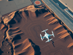
The advent of advanced mapping technologies has transformed how professionals approach geographical data collection. Utilizing unmanned aerial vehicles (UAVs), these techniques allow for the acquisition of high-resolution imagery and detailed topographic assessments more efficiently than conventional methods.
A particularly intriguing feature of aerial surveys is their capability to navigate difficult terrains, such as steep inclines or densely vegetated areas, where traditional vehicles may struggle.
Employing cutting-edge technologies like Lidar and photogrammetry, operators can produce intricate three-dimensional models that significantly enhance spatial analysis.
The incorporation of specialized sensors enables the collection of multispectral data, which imparts critical insights into aspects like vegetation health and land utilization. Such intricate data supports a wide range of industries, including construction, real estate, and environmental monitoring, facilitating improved planning and resource management.
Click here to learn more about: contact
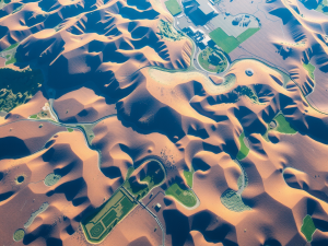
Understanding Aerial Photography
Capturing images from above offers a fresh perspective on how landscapes and urban areas are mapped and analyzed. This method employs advanced technology, such as drones and unmanned aerial vehicles (UAVs), to create detailed visual records of geographical features.
The efficiency of aerial surveys is notable, as they can reduce data collection time significantly, often halving the duration compared to conventional surveying techniques.
The integration of remote sensing tools enhances the accuracy of information gathered, allowing access to remote locations that are challenging to reach by traditional means.
Drones equipped with multispectral imaging can reveal data beyond the visible spectrum, which is particularly useful in sectors like agriculture where monitoring crop health is essential for optimizing irrigation practices. These images are invaluable for environmental assessments, enabling the observation of landscape changes over time.
Insights collected from aerial imagery support informed decision-making processes across diverse industries, including construction and real estate. As the technology behind aerial mapping continues to evolve, the quality and precision of data collection and visualization are expected to improve, making these advanced methods even more reliable for various applications.

The Role Of Drones In Surveys
The integration of aerial technology into mapping practices has transformed the way professionals collect and analyze data. Utilizing advanced tools such as drones allows for the capture of high-resolution images, significantly enhancing the quality of traditional data collection methods.
Equipped with sensors like LiDAR and multispectral imaging, these devices can produce detailed orthophoto maps, revealing the Earth’s topography with extraordinary precision.
The efficiency of this technology permits data gathering in hard-to-reach locations, which not only accelerates project timelines but also mitigates risks to personnel operating in potentially hazardous environments.
For instance, surveys that would typically require several weeks can now often be completed within a few days. This reduction in time translates to cost savings while also enabling more thorough evaluations across various sectors, including construction, agriculture, and environmental monitoring.
As remote sensing technologies evolve, the capacity for drones to deliver accurate and versatile applications in diverse fields continues to increase, underscoring their significance in contemporary mapping efforts.
Aerial Technology in Mapping
- Drones equipped with LiDAR and multispectral sensors produce detailed orthophoto maps with high precision.
- Data collection in difficult-to-reach areas is made more efficient, reducing project timelines from weeks to days.
- The use of aerial technology leads to significant cost savings while allowing for more comprehensive evaluations.
- Remote sensing technologies enhance the versatility and accuracy of applications across sectors such as construction, agriculture, and environmental monitoring.
Benefits Of Lidar Technology
The application of advanced measurement technologies is transforming data collection methods in various fields. Lidar employs laser pulses to measure distances with exceptional precision.
This capability facilitates the creation of high-resolution three-dimensional maps that reveal intricate surface details.
Unique fact: Lidar can detect variations in surface elevation as minute as two centimeters, which is essential for comprehensive topographic mapping.
Another notable advantage of this technology is its efficiency; it can rapidly cover extensive areas compared to traditional surveying techniques. Specifically, some Lidar systems can gather data while flying at speeds up to 200 knots, significantly accelerating project timelines.
This ability is particularly advantageous for sectors like construction, where timely decision-making is paramount. As the reliance on aerial survey methods grows, industries are increasingly utilizing drones equipped with Lidar sensors to enhance their mapping capabilities.
In addition, the integration of high-resolution imagery captured during aerial surveys provides contextual visual support, further enriching analytical processes.
The combination of various mapping techniques, such as photogrammetry and multispectral imaging, broadens the scope of applications for Lidar technology across construction, agriculture, and environmental monitoring sectors.
Understanding the capabilities of each method highlights the importance of selecting appropriate data collection technologies for specific project needs.
High Resolution Mapping Techniques
Utilizing advanced technology for map creation transforms traditional surveying practices into efficient, high-accuracy processes. Unmanned aerial vehicles (UAVs) serve as invaluable tools for collecting extensive data over large areas, capturing high-resolution photographs that facilitate detailed terrain measurement.
These airborne devices can expedite project timelines and reduce costs significantly compared to conventional survey methods.
Sophisticated data collection strategies like photogrammetry allow for the generation of 3D models from overlapping images, enhancing spatial analysis and offering comprehensive geographical insights.
UAVs can operate in environments that may be difficult for ground crews to access, thereby broadening the scope of possible surveys. The use of Lidar technology further elevates mapping precision by employing laser scanning to gather accurate elevation data.
Various industries, including construction and agriculture, rely on these innovative mapping methods to deliver high-quality results that support effective decision-making and strategic planning.
Building on the benefits of Lidar technology, these aerial techniques demonstrate how efficient data collection can transform project outcomes.
As the focus shifts to exploring satellite imagery uses, understanding the interplay of UAV and satellite data further enriches the mapping landscape.
The combination of both data sources enables even greater detail and contextual analysis, propelling industries forward in their efforts to harness spatial information effectively.
Advanced Mapping Technology
- Unmanned aerial vehicles (UAVs) capture high-resolution photographs for detailed terrain measurement.
- UAVs can significantly reduce project timelines and costs compared to traditional surveying methods.
- Lidar technology utilizes laser scanning to provide accurate elevation data, enhancing mapping precision.
- The combination of UAV and satellite imagery allows for greater detail and contextual analysis in mapping.
Exploring Satellite Imagery Uses
High-resolution images captured from above serve as a transformative tool for various sectors. These aerial images, often obtained through advanced sensors, offer insights that are not easily visible from the ground.
For example, infrared technology can assess vegetation health and determine water stress levels, which proves beneficial for farming.
A lesser-known application involves the use of remote sensing data to create comprehensive urban development plans—these images track land use changes over time, which is vital for effective zoning decisions.
Environmental monitoring also heavily relies on these capabilities, allowing for timely detection of issues like deforestation. Industries are increasingly adopting geographic information systems (GIS) to harness this type of data, thus facilitating informed decision-making.
Light detection and ranging (Lidar) technology further refines data collection by providing precise topographic information, making it indispensable for thorough mapping solutions.
Data Collection Methods For Aerial Surveys
The evolution of surveying techniques has broadened the possibilities for gathering geospatial information. Traditional methods often entail extensive time commitments and require significant manpower, while modern approaches streamlined through the use of UAVs can survey large landscapes rapidly.
A prevalent method used to create detailed topographical models is Lidar, which employs laser light to collect precise elevation data.
This technique yields high-resolution information, vital for monitoring terrain alterations, such as erosion.
Photogrammetry is another widely utilized approach, allowing professionals to create intricate 3D models based on aerial imagery, thereby enabling effective project visualization prior to launch. Multispectral imaging specializes in capturing data across various wavelengths, assessing ecosystem health, and offering insights into land and crop conditions.
The diverse range of techniques not only enhances accuracy in data collection but also supports multiple applications across sectors like construction and environmental monitoring, thus improving project reliability. As advances in remote sensing technologies continue to emerge, the efficacy of these data collection methods becomes increasingly significant for any robust analysis of spatial phenomena.
| Technique | Description |
|---|---|
| Lidar | Uses laser light to collect precise elevation data for high-resolution topographical models. |
| Photogrammetry | Creates intricate 3D models from aerial imagery for effective project visualization. |
| Multispectral Imaging | Captures data across various wavelengths to assess ecosystem health and land conditions. |
| UAVs | Streamline surveying processes, allowing for rapid surveys of large landscapes. |
Advances In Remote Sensing Technologies
Recent developments have significantly influenced the methodologies employed for collecting and analyzing geographical data. A prominent progression involves the incorporation of specialized sensors and cameras used in aerial assessments, markedly improving mapping capabilities.
These sophisticated tools yield high-resolution images that undergo processing to produce detailed 3D maps with exceptional accuracy.
Surprisingly, many are unaware that such techniques enable the monitoring of crop health by evaluating vegetation indices, which play an important role in agriculture today.
The use of multispectral imaging facilitates the identification of subtle land use changes and environmental conditions. This innovation proves particularly advantageous in remote or challenging terrains, providing valuable insights that guide essential decision-making processes.
Consequently, UAVs equipped with these advanced technologies are becoming integral across various sectors, enhancing efficiency in data collection and spatial analysis.
Transitioning from advanced mapping methods, it is imperative to recognize the role geospatial data plays in a multitude of applications. The importance of accurate and timely data cannot be overstated, as it underpins various industries from construction to environmental monitoring.
The Importance Of Geospatial Data
Data derived from various spatial contexts plays an essential role in informing decisions across numerous sectors. Organizations leveraging drone technology can create detailed maps that uncover insights typically overlooked by conventional surveying methods.
For example, UAVs equipped with sensors like Lidar can produce 3-dimensional topographic data, yielding accurate elevation models vital for construction and environmental assessments.
This level of precision supports improved planning and resource allocation, particularly in agriculture, where monitoring vegetation growth is paramount for optimizing yield.
The integration of GPS technology allows for real-time data processing, enabling teams to respond promptly to evolving conditions. Utilizing aerial surveys can significantly reduce project timelines and costs, presenting an efficient alternative for stakeholders in diverse fields.
The advancements in remote sensing technologies continue to transform how geospatial information is collected and utilized, underscoring the growing relevance of this data in today’s landscape.
Drone Technology and Geospatial Data
- Drone technology enables the creation of detailed maps that reveal insights often missed by traditional surveying methods.
- UAVs equipped with sensors like Lidar can generate accurate 3-dimensional topographic data crucial for construction and environmental assessments.
- Real-time data processing through GPS integration allows teams to quickly adapt to changing conditions.
- Aerial surveys can significantly reduce project timelines and costs, making them an efficient alternative for various stakeholders.
Aerial Survey Technology Trends Eco Friendly Perspectives In Land Surveying
Aerial Surveying Vs Ground Surveying Drone Insights