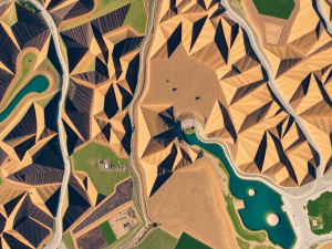
The integration of aerial technology into the surveying process marks a significant shift in how data is collected and analyzed. Equipped with advanced sensors, unmanned aerial vehicles can capture high-resolution images, which facilitate remarkably accurate topographical mapping.
This modern approach enables professionals to conduct surveys substantially more quickly than was possible with traditional techniques.
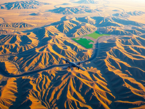
Aerial methodologies excel in accessing challenging terrains, such as steep hillsides or densely forested regions, where conventional surveying equipment may struggle.
A unique aspect to consider is the compatibility of UAVs with Geographic Information Systems, which enhances data analysis capabilities.
This synergy provides a comprehensive view of the landscape, supporting efforts in environmental monitoring and urban development. The application of Lidar technology, which employs laser light for precise distance measurements, further elevates the accuracy of land assessments by generating intricate 3D representations of the terrain.
These innovations showcase the cost-effectiveness of aerial mapping solutions, with applications spanning various sectors from construction to agriculture. As drone technology continues to evolve, it underscores the adaptability of modern surveying techniques, paving the way for more efficient and comprehensive data gathering, including advanced applications in topography and geographic information systems that enhance the capabilities of aerial photography and Lidar for precise land surveying and construction projects.
Click here to learn more about: contact
Revolutionizing Land Assessment
The landscape of land evaluation is undergoing a significant transformation due to advancements in drone technology. Aerial data collection has evolved remarkably, shifting from labor-intensive ground surveys to sophisticated UAV applications.
Traditional methods often required considerable time and workforce to gather and analyze information.
This inefficiency is now being addressed by swift aerial assessments capable of surveying extensive areas with remarkable speed.
Utilizing multispectral imaging, drones are able to capture data across multiple wavelengths, revealing insights beyond the visible spectrum. This capability is particularly advantageous in agriculture, enabling the assessment of crop health through various light frequencies.
Drones are proficient in generating 3D models of terrains, which significantly enhances spatial analysis and planning precision. The incorporation of high-resolution imagery ensures that stakeholders receive comprehensive data that supports informed decision-making processes.
With the application of photogrammetry techniques, land developers and environmental planners can effectively visualize changes over time, fostering better strategies and more efficient conservation initiatives.

How Drones Enhance Survey Accuracy
Utilizing modern technology has transformed how data is gathered for land assessment. Aerial surveys employing unmanned aerial vehicles (UAVs) provide a level of accuracy that traditional methodologies may struggle to achieve.
These aircraft excel in accessing difficult terrains, often overlooked by standard survey techniques, thus broadening the scope of possible applications, particularly in sectors such as construction and environmental monitoring.
Drones equipped with advanced sensors, including Lidar, are capable of capturing intricate depth information, ensuring accurate elevation measurements.
This precision leads to the development of highly detailed 3D computer graphics models, which facilitate improved analysis of site conditions. The incorporation of Ground Control Points (GCPs) significantly enhances the georeferencing of images, which minimizes distortion and ensures high fidelity in the resulting data.
Consequently, the efficiency of project management is optimized, as both timelines and costs are effectively reduced, demonstrating the strategic advantage of drone surveys across various industries.
Drone Surveys
- Unmanned aerial vehicles (UAVs) provide superior accuracy compared to traditional land assessment methods.
- Drones can access difficult terrains, expanding the range of applications in construction and environmental monitoring.
- Advanced sensors like Lidar enable drones to capture detailed depth information for precise elevation measurements.
- The use of Ground Control Points (GCPs) enhances image georeferencing, reducing distortion and ensuring high-quality data.
Unmanned Aerial Vehicles In Topography
The integration of advanced aerial technology has revolutionized the methods used for detailed mapping of landscapes. Drones equipped with sophisticated sensors can capture images and data with remarkable precision, often surpassing the capabilities of traditional surveying techniques.
One fascinating capability is their proficiency in generating accurate contour lines across uneven terrains, which plays a significant role in analyzing changes in land elevation.
These modern tools facilitate swift aerial surveys, significantly cutting down the duration required for data collection.
Interestingly, they are especially advantageous in areas prone to landslides, where it may be unsafe for human surveyors to operate.
This not only increases safety but also widens the applicability of drone surveys across diverse sectors, such as construction, agriculture, and environmental monitoring. The ability to gather comprehensive survey data in challenging locations supports a wide range of mapping and analysis tasks, ultimately enhancing project outcomes with high-resolution aerial insights.
Streamlining Construction With Aerial Surveys
The adoption of advanced aerial technologies has transformed the conventional approaches to collecting land data in the construction sector. Utilizing drone technology, these innovations facilitate the creation of detailed topographic surveys that improve project planning and implementation.
Drones can efficiently cover expansive survey sites, significantly reducing the time required for traditional methods.
This increase in efficiency contributes to notable cost savings while also minimizing the disruption that might affect ongoing construction projects.
Equipped with sophisticated sensors like drone Lidar, these unmanned aerial systems provide precise elevation information critical for tasks such as grading and drainage design. The high-resolution drone images captured during the surveying process enhance visualization and allow for more informed decision-making throughout various stages of construction.
By enabling real-time data collection, aerial surveys empower teams to monitor project progression and swiftly address emerging challenges. As the surveying industry progresses, integrating these aerial services will be essential for maintaining a competitive edge in project execution.
Advanced Aerial Technologies in Construction
- Drones can cover large survey areas quickly, reducing time compared to traditional surveying methods.
- Utilizing drone technology can lead to significant cost savings in construction projects.
- Advanced sensors like drone Lidar provide accurate elevation data critical for grading and drainage design.
- High-resolution drone images improve project visualization and support informed decision-making.
The Future Of Mapping And Cartography
Innovations in geographic data collection are reshaping the landscape of mapping. Recent developments in aerial survey technology leverage specialized drones equipped with advanced sensors like LiDAR and photogrammetry to capture intricate terrains with remarkable efficiency.
These drones can fly at various altitudes, enabling the collection of data that traditional land surveying frequently misses.
The accuracy of drone survey data proves beneficial for land assessments, making these solutions crucial in sectors such as agriculture and construction.
The integration of drone surveying software has enhanced data processing capabilities, allowing for swift project execution. With the capacity to generate detailed 3D models and orthomosaic maps, these technologies significantly improve environmental monitoring and urban planning.
Collaborative efforts between aerial mapping and GIS technologies promise to further elevate spatial analysis and decision-making processes, facilitating a more informed approach to development and resource management.
Benefits Of Using Drone Imagery
Implementing aerial technology for imaging fundamentally transforms professional practices in mapping and surveying. Drones equipped with high-quality camera technology can collect data at an unprecedented scale.
For instance, aerial surveys can capture three-dimensional representations of terrains quickly, often finishing in hours what traditional methods might take days to complete.
This shift not only enhances efficiency and cost but also significantly reduces expenses associated with survey equipment.
Interestingly, drones can fly at various altitudes, allowing them to cover a wide range of terrains, including areas that are difficult or dangerous for ground personnel to access. They can gather multispectral data, which provides insights beyond visual imaging, such as vegetation health analysis.
The integration of this data with Geographic Information Systems (GIS) allows for comprehensive spatial analysis, facilitating improved decision-making in areas like environmental monitoring and construction planning.
Aerial Technology in Mapping and Surveying
- Drones can complete aerial surveys in hours, significantly faster than traditional methods.
- They reduce costs associated with survey equipment and improve overall efficiency.
- Drones can access difficult or dangerous terrains, enhancing data collection capabilities.
- Integration of drone data with GIS allows for detailed spatial analysis and better decision-making.
Understanding Drone Flight Planning
Effective planning for drone operations plays a significant role in enhancing aerial surveying and ensuring high data accuracy. This meticulous approach allows operators to leverage the advantages of drones, enabling efficient mapping of extensive areas.
Unique fact: Drones can quickly cover 100 acres in a single flight, significantly shortening the timeframe for data collection compared to traditional methods.
Mission objectives must outline the specific data needed, while geofencing helps define the operational boundaries.
Unique fact: Automated flight planning tools can adjust routes in real-time based on changing conditions, greatly enhancing efficiency. Compliance with regulatory requirements is necessary, as rules can vary significantly by location.
Unique fact: Many drone operations may require specific permits depending on altitude and airspace usage. Overall, this process ensures successful missions and valuable data collection, making it vital for those needing special mapping in sectors like construction and environmental monitoring.
Transitioning into the subsequent section, exploring efficient techniques for data collection reveals further insights into maximizing the impact of drone imagery in various industries.
Efficient Data Collection Techniques
The utilization of aerial technology has transformed how data is captured across various sectors. High-end surveying drones have dramatically improved the efficiency of data acquisition by allowing for the collection of large surveying areas in a fraction of the time typically required.
These systems can operate autonomously, capturing detailed measurements and images that can significantly reduce human error while enhancing overall accuracy.
A lesser-known advantage of drone surveys is their ability to minimize environmental disruption, particularly important in fragile ecosystems.
The applications of drone surveys are diverse, spanning from civil construction sites to environmental monitoring, enabling a single drone to conduct extensive surveys rapidly. These collected datasets can reduce weeks off typical surveying workflows, ultimately boosting productivity levels.
When the compliant surveying process is carefully planned, it ensures adherence to regulatory requirements, facilitating the effective application of drone technology. Integrating UAV mapping with existing systems not only enhances decision-making but also optimizes resource management, showcasing the extensive potential of modern aerial surveying methods.
Aerial Technology in Surveying
- High-end surveying drones can cover large areas much faster than traditional methods, reducing survey time significantly.
- Drone surveys minimize human error by capturing detailed measurements and images autonomously.
- These technologies are environmentally friendly, causing less disruption in sensitive ecosystems.
- Integrating UAV mapping with existing systems enhances decision-making and optimizes resource management.
Aerial Imaging Technology Unique Perspectives
LiDAR Survey Developments Drones Transform Mapping