Advanced techniques in data collection enable the observation of Earth from unique vantage points. Among the notable features of NASA Earthdata is its extensive collection of satellite imagery, which offers deep insights into atmospheric conditions and ecological changes.
For example, satellite data can identify temperature fluctuations within oceans, playing a pivotal role in shaping global weather patterns.
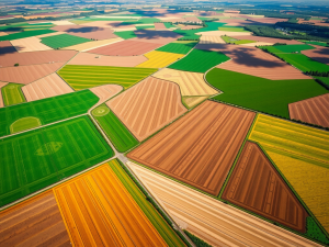
This platform supports the monitoring of land use changes, including deforestation and urbanization, through an extensive archive of high-resolution images captured over time.
The integration of drones and UAVs into remote sensing practices enhances the precision of data collection, allowing for specialized mapping in areas that are difficult to access. Technologies such as Lidar serve to penetrate dense vegetation, uncovering ground topography and revealing geological features that traditional surveying might miss.
This synergy of aerial and satellite imaging represents a significant leap in our understanding of environmental dynamics.
Click here to learn more about: contact
Latest Advancements In Remote Sensing Technology
Innovative technologies have transformed data collection and analysis methods, presenting new possibilities across multiple sectors. Aerial surveyors are increasingly utilizing unmanned aerial vehicles (UAVs) for efficient mapping and high-resolution data acquisition.
This approach is made even more effective through the integration of artificial intelligence, which optimizes data processing capabilities and fosters better decision-making based on detailed information.
Notably, advanced sensor technology enables the capture of multispectral and hyperspectral images, offering valuable insights related to plant health and environmental shifts.
The implementation of 5G technology has further enhanced data transmission speeds, contributing to more immediate data processing and quicker responses in various applications. This progression is particularly significant in industries such as agriculture, construction, and mining, where precise mapping can lead to substantial operational benefits.
As UAV technology advances, it promises to enhance both efficiency and accuracy in data collection, paving the way for innovative methodologies that redefine our understanding of spatial analysis. Transitioning from these advancements leads naturally to exploring satellite imaging techniques, which complement aerial data collection through additional layers of Earth observation.

Understanding Satellite Imaging Techniques
Advancements in imaging capabilities have significantly reshaped our knowledge of Earth’s surface. Satellites capture images from great altitudes, utilizing sophisticated technology to yield valuable insights across diverse domains.
An unexpected aspect is the ability of satellites to deliver near real-time images, enabling timely observation of rapid environmental changes, including natural disasters.
Such data facilitates damage assessment and resource allocation for effective response.
Optical imaging employs sensors reflecting light, with applications spanning urban planning and agriculture, while radar techniques function effectively amid cloud cover, providing information regardless of weather conditions. This feature proves particularly beneficial for monitoring the polar regions of Earth, where atmospheric variability can impede observations.
The integration of multispectral and hyperspectral imaging further enriches our understanding by analyzing various energy wavelengths, assisting in vegetation tracking, and contributing to forest management and conservation initiatives. Aerial surveys enhance traditional mapping techniques by using drones to capture high-resolution images and facilitate spatial analysis, serving industries such as construction and environmental monitoring.
Imaging Capabilities
- Satellites provide near real-time images for rapid environmental change observation.
- Optical imaging is used in urban planning and agriculture, while radar techniques operate in all weather conditions.
- Multispectral and hyperspectral imaging assist in vegetation tracking and forest management.
- Drones enhance traditional mapping by capturing high-resolution images for various industries.
Exploring NASA S Earth Observation Capabilities
Utilizing advanced technologies for planetary observation is essential to comprehending Earth’s dynamic systems. NASA actively operates satellites specifically designed for remote sensing applications, which collect vital spectral data across a range of wavelengths.
This data supports researchers in monitoring changes in land use and understanding atmospheric phenomena.
Notably, the Landsat program, initiated in 1972, has delivered continuous observation data for over four decades, marking it as one of the longest-running missions ever established.
In addition to traditional methods, the integration of machine learning techniques within NASA’s framework enhances the analysis of remote sensing data, enabling faster identification of environmental shifts. These capabilities also extend their utility beyond scientific research; they facilitate improved communication among stakeholders in various sectors, including agriculture and disaster management, thus promoting timely responses and informed decision-making.
As advancements unfold, remote sensing technology promises to further innovate global observation and management strategies.
The Role Of Sensors In Data Collection
Advanced technologies play a crucial role in optimizing data collection processes, particularly within the context of aerial surveys. Sensors enable UAVs to gather precise information about earth features instantaneously.
Among the standout technologies is Lidar, which emits laser pulses to create detailed ground models, even in areas concealed by dense vegetation.
Photogrammetry is another significant method that transforms 2D images into accurate 3D models, achieving centimeter-level accuracy important for refined analysis. Multispectral imaging captures data related to various earth features by utilizing electromagnetic radiation across different wavelengths, thereby enabling researchers to find the latest insights into vegetation and monitor changes over time with high temporal resolution.
Advanced Technologies in Aerial Surveys
- Lidar technology can penetrate dense vegetation, providing detailed ground models that traditional methods may miss.
- Photogrammetry achieves centimeter-level accuracy, essential for precise analysis and mapping of terrain.
- Multispectral imaging allows researchers to monitor vegetation health and changes over time by capturing data across various wavelengths.
- UAVs equipped with advanced sensors can collect data instantaneously, enhancing the efficiency of aerial surveys.
Insights From Recent Remote Sensing Research
Advancements in technology are transforming how professionals gather and interpret information related to the earth’s surface. A significant innovation is the integration of UAV mapping with multispectral imaging, which facilitates the detection of variations in land cover types that may not be perceptible to the human eye.
This capability allows for the identification of health discrepancies in crops, which could impact overall agricultural productivity.
Remarkably, drones equipped with sophisticated sensors can effectively capture data even amidst cloud cover, thereby enhancing the reliability of assessments.
Data acquired through UAV methods is typically processed in a matter of days, contrasting sharply with traditional techniques that may require weeks. This quick turnaround is particularly important in areas such as disaster management, where timely information can indeed save lives.
The application of AI in analyzing this wealth of data streamlines operations and unveils insights previously considered unattainable.
Transitioning to the practical applications, remote sensing technologies play a pivotal role in agriculture.
UAV mapping services can significantly enhance precision in field assessments, improving crop monitoring and resource management.
The ability to perform aerial surveys allows for high-resolution imaging, which, when combined with data analysis tools, leads to informed decision-making in farming practices.
Applications Of Remote Sensing In Agriculture
Modern agriculture increasingly benefits from innovative technological advancements that transform traditional farming methods. The utilization of drones equipped with multispectral sensors enables farmers to monitor crop health across various regions of the electromagnetic spectrum, offering valuable insights into plant vitality.
This technology underpins precision agriculture by delivering real-time data that enhances decision-making processes related to irrigation, fertilization, and pest management.
Aerial imagery obtained during the growing season demonstrates that subtle variations in reflected or emitted energy can indicate nutrient deficiencies within crops.
By effectively monitoring soil health, farmers can assess moisture levels and optimize irrigation schedules, which is essential for conserving water resources. UAVs facilitate yield estimations by analyzing high spatial resolution images, assisting in the forecasting of crop performance prior to harvest.
These advanced surveying techniques empower agricultural stakeholders to significantly enhance productivity while fostering sustainable practices within their operations.
Modern Agriculture Technology
- Drones with multispectral sensors provide insights into crop health across different wavelengths, aiding in precision agriculture.
- Real-time data from aerial imagery helps farmers make informed decisions on irrigation, fertilization, and pest management.
- Monitoring soil health through UAVs allows for better moisture management and optimized irrigation schedules, conserving water resources.
- High-resolution images from drones assist in yield estimations and crop performance forecasting prior to harvest.
Investigating Human Impact On Earth S Environment
The evolution of technology has enabled unprecedented observation of our planet, revealing the profound consequences of human endeavors on natural systems. Aerial surveys utilizing drones serve as a pivotal tool in understanding these impacts, facilitating the acquisition of information through real-time data collection.
For example, drones fitted with thermal imaging can pinpoint temperature anomalies related to pollution sources.
A significant case study involves the monitoring of the Gnangara groundwater system, where UAVs assist in evaluating both water quality and availability.
Drones can capture data across different wavelengths, enhancing the analysis of vegetation health and land use patterns. This innovative technology provides a nuanced understanding of deforestation trends, which is essential for comprehending the broader environmental implications of human activity.
The precision of data derived from various spectral bands allows for rigorous environmental assessments and informed decision-making in resource management.
Transitioning from applications in agriculture, the capabilities of aerial surveyors extend into diverse sectors including construction and environmental monitoring. The use of UAVs not only streamlines the mapping process but also supports accurate spatial resolutions essential for effective planning and resource allocation.
As society increasingly relies on these technologies, it is crucial to consider how they will evolve in the coming years. Looking ahead, the future of remote sensing technology promises further advancements that could enhance our understanding of environmental changes, as innovative satellite systems operating in geostationary orbits utilize different wavelengths, including microwave energy, to identify different spectral bands for passive systems, enabling the use of altimeters with higher spatial resolutions, thus improving image interpretation and aiding NASA in its observations of Earth, which scientists have called essential for measuring changes in systems like the Gnangara groundwater system, while the commercial space sector continues to play a pivotal role in the acquiring of information crucial to our planet’s health.
The Future Of Remote Sensing Technology
Recent advancements in technological platforms are significantly reshaping how data regarding the planet is collected and analyzed. The integration of aerial, drone, and UAV services has led to remarkable improvements in data collection methods, allowing for previously unattainable levels of precision in mapping.
For example, UAVs equipped with sensors can gather high-resolution images, enabling detailed spatial analysis across various applications, such as environmental monitoring and construction.
Such developments are essential for monitoring global precipitation measurement, which plays a crucial role in understanding complex climate patterns.
The transformation from raw pixels to products allows decision-makers to derive actionable insights from the data collected. Industries such as agriculture, disaster management, and urban planning can leverage these innovative mapping capabilities to conduct thorough environmental assessments.
Enhanced data visualization aids in recognizing spatial changes that are vital for effective resource management. Compliance with UAV operation regulations ensures that these advancements are utilized ethically, fostering sustainable practices and promoting responsible stewardship of everything on earth.
UAV Survey Applications Elevate Mapping With Drones
Drone Survey Advancements Unveiled