Innovations in technology are driving a transformation in mapping processes. Unmanned aerial vehicles equipped with high-resolution cameras and Lidar systems capture intricate topography with impressive accuracy.
This evolution streamlines the surveying process while enhancing data collection efficiency.
Aerial surveys allow professionals to explore difficult terrains, minimizing manual labor and reducing potential hazards.
The addition of 3D modeling significantly enhances the visualization of project sites, fostering improved planning and informed decision-making. These advancements promise a bright future for UAV surveying, unlocking new opportunities across various sectors.
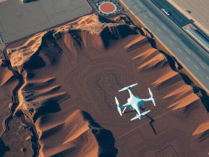
Transforming Surveying With Drones
Recent advancements in aerial technology are reshaping the surveying sector, bringing forth innovative techniques that enhance efficiency and accuracy. These unmanned aircraft have become indispensable for collecting data from the sky, introducing a new level of reliability in traditional practices.
With improved information gathering capabilities, they streamline the measurement process, saving both time and resources.
Real-time sensor inputs allow for accurate mapping of expansive terrain, providing invaluable insights for various industries.
Detailed orthophotos generated from these flights support construction and mining operations, enriching project planning and execution. As technology progresses, the potential for automating surveying tasks further solidifies the role of aerial solutions in the future

Benefits Of Unmanned Aerial Vehicles
The introduction of advanced aerial technologies has significantly transformed methods across various sectors, delivering solutions that are often more efficient than conventional approaches. Cost-effectiveness stands out as a major advantage, allowing organizations to reduce operational expenditures associated with traditional surveying methods.
Diminished manpower requirements for data collection lead to notable financial savings.
Another compelling advantage is increased efficiency.
These vehicles enable rapid data collection and processing times. They can swiftly survey extensive areas, proving invaluable for applications such as urban planning and environmental monitoring.
Through the integration of these technologies, businesses optimize their operations and enhance overall productivity, setting the stage for future advancements. Transitioning to enhancing accuracy with Lidar technology, it’s clear that these innovations continue to elevate operational standards
Enhancing Accuracy With Lidar Technology
Advancements in surveying methodologies have transformed the landscape of data acquisition. The ability to create detailed representations of the environment contributes significantly to the accuracy of land assessments.
Enhancements over traditional techniques come from integrating real-time kinematic positioning, which allows for immediate feedback and adjustments.
Drone technology plays a pivotal role in this transformation, facilitating the execution of surveys with remarkable precision.
Each measurement collected during a drone survey can be geotagged, ensuring every data point is accurately located on the mapping grid. This efficiency not only accelerates project timelines but also reduces the potential for errors, reinforcing the reliability of land survey results.
Transitioning from the benefits of unmanned aerial vehicles, it’s clear that the capabilities extend further into areas such as 3D modeling, which offers even more effective mapping strategies.
Exploring 3D Modeling For Effective Mapping
Advancements in technology are propelling the field of cartography into new dimensions, enabling more effective visualizations of our environment. This innovative approach enhances data collection processes, allowing surveyors to visualize elevation changes and terrain details more accurately.
By integrating 3D models with traditional survey methods, planners gain a comprehensive understanding of their survey area.
Drones for surveying play a significant role in this integration, capturing high-resolution imagery that contributes to the elevation model.
The combination of technology and skillful modeling empowers professionals to make informed decisions throughout survey projects. Transitioning from techniques like Lidar technology can further enhance accuracy, leading to more precise mappings.
Next, utilizing photogrammetry in drone surveys offers additional methodologies to enhance the overall process.
Advancements in Cartography
- Integration of 3D models with traditional survey methods enhances understanding of terrain.
- Drones capture high-resolution imagery, improving the accuracy of elevation models.
- Transitioning to technologies like Lidar increases mapping precision.
- Photogrammetry in drone surveys provides additional methodologies for effective data collection.
Utilizing Photogrammetry In Drone Surveys
Innovative technologies are transforming how various sectors approach surveying tasks, significantly enhancing efficiency and precision. Aerial surveys utilizing advanced drone systems enable the collection of high-resolution images that can be converted into detailed 3D models and topographic maps.
Drones equipped with sophisticated sensors facilitate rapid data capture, leading to improved accuracy in mapping projects.
These surveying techniques also result in notable cost savings when compared to traditional manned aircraft methods.
With valuable drone survey data at their disposal, professionals across fields such as construction and environmental monitoring can make well-informed decisions. Transitioning from the exploration of 3D modeling, it’s essential to recognize the pivotal role of sensors in optimizing data collection processes, further enhancing survey outcomes.
The Role Of Sensors In Data Collection
Modern technology has transformed the way data is captured, particularly through the use of specialized devices. Advanced tools facilitate effective drone operations, ensuring comprehensive data collection across various sectors.
These instruments can capture detailed insights, contributing significantly to the accuracy of drone surveys.
Different varieties of sensors, including optical and LiDAR, deliver invaluable contributions to mapping and surveying tasks.
The incorporation of these devices enhances the functionality of aerial platforms, empowering them to provide extensive data sets. As innovations unfold, the influence of these tools on the surveying industry continues to progress, promoting advancements in data acquisition.
Transitioning from capturing imagery to applying elevation mapping techniques allows for improved precision in topographical assessments.
Modern Technology in Data Collection
- Advanced tools enhance drone operations for comprehensive data collection.
- Various sensors, such as optical and LiDAR, improve mapping and surveying accuracy.
- Incorporation of specialized devices significantly boosts the functionality of aerial platforms.
- Transitioning to elevation mapping techniques enhances precision in topographical assessments.
Elevation Mapping Techniques For Precision
Precision in mapping landscapes has far-reaching implications across diverse sectors. The need for manual surveying can often be time-consuming and labor-intensive.
Drone surveying provides a modern alternative that captures intricate details with remarkable accuracy.
Launch the drone equipped with high-resolution cameras and experience efficient collection of elevation data.
This technology significantly reduces the costs associated with traditional surveying methods, allowing for better resource allocation. As these devices can quickly survey large areas, the insights gained enhance the quality of spatial analysis.
With advancements in drone flight planning, the transformative effect on urban planning and environmental studies becomes increasingly evident.
Revolutionizing Urban Planning Through Aerial Surveys
The integration of advanced technology is reshaping the landscape of city development, paving the way for innovative methodologies. A comprehensive drone approach allows for the collection of extensive survey data processed in real-time.
With the precision of drone equipment, stakeholders can greatly enhance their decision-making processes.
The accuracy of drone surveying effectively identifies land use patterns and addresses environmental considerations.
As urban spaces evolve, the potential of drone technology emerges as a vital instrument for fulfilling surveying needs. This advancement fosters opportunities for more informed, strategic planning, benefiting communities through improved results.
Drone Technology in Urban Development
- Drones can collect extensive survey data in real-time, improving efficiency.
- Precision drone equipment enhances decision-making for stakeholders.
- Drone surveying accurately identifies land use patterns and environmental issues.
- Utilizing drone technology fosters strategic planning for urban communities.