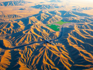
Precision defines the landscape of modern surveying, where advanced techniques transform traditional practices. Unmanned aerial vehicles have emerged as powerful tools for gathering fresh insights, facilitating data collection that surpasses previous capabilities.
These technologies empower surveyors to execute mapping and environmental monitoring with remarkable speed and accuracy.
Employing both fixed-wing and multi-rotor drones ensures adaptability in acquiring detailed information from elevated perspectives.
As this innovative technology progresses, the opportunities for improving survey outcomes continue to expand, reinforcing the role of UAV data collection in shaping contemporary surveying methodologies.
Innovative Drone Technology For Data Gathering
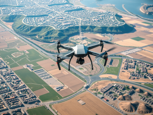
Accessing accurate information is fundamental for effective decision-making, and the utilization of advanced aerial vehicles has emerged as a transformative approach in the field of observation. These sophisticated tools enable industries to gather insights with remarkable efficiency.
Equipped with high-resolution cameras and lidar systems, they facilitate precise data collection, significantly enhancing the integrity of the insights gathered.
Their capability to swiftly traverse extensive terrains positions them as formidable assets in various domains, such as resource management and environmental analysis.
As these vehicles incorporate advancements in machine learning and the Internet of Things, the potential to extract valuable information is set to redefine our understanding of the natural environment

The Benefits Of Aerial Mapping
The use of advanced imaging technology opens doors to improved operational methods across diverse sectors. It leads to an increase in efficiency, particularly highlighted by the rapid data collection capabilities of UAVs, which allows for extensive areas to be surveyed swiftly, making it an excellent fit for construction and engineering projects.
Enhanced accuracy achieved through high-resolution imagery captures every minute detail, significantly reducing the risk of human error.
This technological leap also supports tasks like flight planning and risk assessment, empowering teams to make informed decisions.
Consequently, this innovative approach not only conserves time but also enhances resource allocation.
Enhancing Surveys With UAVs
The integration of innovative aerial technology significantly alters conventional surveying practices, offering remarkable efficiency. These systems can rapidly gather data over large terrains, significantly cutting down the time typically required for ground assessments.
Equipped with sophisticated sensors, the accuracy and richness of collected aerial information are greatly improved.
Such advancements not only reduce workforce requirements but also lower energy consumption involved in surveying activities.
As sectors widely embrace these cutting-edge solutions, the demand for trustworthy and precise information continues to rise. Embracing these methods facilitates superior decision-making processes across diverse disciplines.
Effective Data Collection Techniques
Gathering high-quality information is fundamental for effective decision-making. Utilizing drones for data acquisition has significantly transformed how information is captured across numerous sectors.
These devices can swiftly obtain high-resolution imagery and gather specifics that traditional techniques often struggle to achieve.
Employing advanced technologies, such as multi-point path planning, enhances the efficiency of data processing and analysis.
This not only streamlines operations but also elevates the quality of the data collected, making it an indispensable resource for informed choices. Transitioning from UAVs to utilizing sensors for environmental monitoring can further augment data capture capabilities and enrich the overall analysis.
| Data Acquisition Method | Advantages |
|---|---|
| Drones | Swift high-resolution imagery capture |
| Multi-point path planning | Enhanced efficiency in data processing |
| Sensors for environmental monitoring | Augmented data capture capabilities |
| Overall data quality | Indispensable for informed decision-making |
Utilizing Sensors For Environmental Monitoring
The integration of advanced devices is transforming the way we monitor our surroundings. These tools function as effective data collectors, measuring important variables such as temperature, humidity, and air quality.
Utilizing various types of data collection methods allows researchers to gather real-time insights that shape important decisions.
Employing a path planning algorithm with UAV technology expands the potential for aerial data collection.
Drones fitted with sensors can follow a trajectory planning strategy that maximizes coverage and efficiency. This innovative approach enhances data analysis, leading to improved monitoring and informed policy-making in environmental conservation efforts.
Streamlining Research With UAV Data
Advancements in technology have enabled a significant evolution in research practices, particularly through the deployment of aerial systems. This data collection mode allows researchers to gather vital information with remarkable speed and accuracy.
Utilizing UAV systems can lead to enhanced operational efficiency while effectively cutting costs associated with traditional methodologies.
The wireless communication capabilities of these devices allow for real-time data acquisition, which is crucial for timely decision-making across various fields.
This innovative approach not only speeds up research processes but also ensures extensive area coverage, maximizing the quality of the insights gathered. Transitioning from sensors employed for environmental monitoring, it is essential to consider how to optimize flight paths for even more effective data collection.
Aerial Systems in Research
- Aerial systems enable rapid data collection, significantly reducing research time.
- Utilizing UAV systems can decrease operational costs compared to traditional research methods.
- Real-time data acquisition from aerial systems supports timely decision-making in various fields.
- Optimizing flight paths can enhance the effectiveness of data collection for environmental monitoring.
Optimizing Flight Paths For Efficient Collection
Maximizing the effectiveness of UAV technology relies on meticulously planned routes for data collection. Organizations can efficiently collect data by focusing on strategic path selection tailored to their specific needs.
Factors such as terrain and environmental conditions significantly influence the collection of data, allowing for a comprehensive survey of the target area.
Advanced software tools enhance this planning process, streamlining the strategies needed to gather data in a timely manner.
As industries increasingly utilize UAVs for reducing data acquisition times, the optimization of flight trajectories enhances data availability and supports future research directions.
Future Trends In Drone Data Acquisition
Advancements in airborne technology are driving a transformation in data collection methodologies. The implementation of deep learning techniques allows UAVs to process raw data with enhanced efficiency.
This optimization not only maximizes data accuracy but also facilitates timely UAV returns of vital information.
Various research initiatives are concentrating on improving global path planning, enabling drones to traverse intricate environments seamlessly.
As industries adopt drone capabilities, research applications will broaden, leading to innovative proposed solutions that tackle emerging needs in data gathering and interpretation.