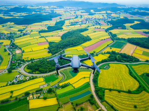
The advancements in technology have significantly transformed how terrain is mapped and analyzed. A distinctive method within this domain is orthomosaic mapping, which integrates multiple aerial photographs into a singular, highly detailed image, thus offering a true-to-scale representation of the landscape.
Another innovative approach is 3D mapping, utilizing advanced algorithms to construct three-dimensional models of terrains, facilitating comprehensive analysis.
Thermal imaging is particularly valuable for detecting temperature variations from aerial platforms, proving essential for identifying energy loss in structures or monitoring wildlife activity.
Multispectral imaging captures data across various wavelengths, delivering insights into vegetation health and environmental conditions.
These innovative types of mapping not only enhance data accuracy but also expand applications across sectors such as construction and agriculture, leading to a transformation in conventional surveying techniques.
Click here to learn more about: contact
Understanding Different Types Of Aerial Mapping
Various specialized techniques exist within the realm of aerial mapping, each utilizing advanced technology to gather detailed information with high efficiency. Orthomosaic mapping is one significant method, producing accurate, high-resolution images through the stitching of multiple aerial photographs while correcting for lens distortion.
This process guarantees a precise representation of the area surveyed, which is crucial for accurate assessments.
Another notable technique is Lidar mapping, where laser light measures distances and penetrates dense vegetation.
This unique ability often reveals elevation data that traditional surveying methods might overlook. Multispectral imaging captures data across multiple wavelengths, offering valuable insights particularly beneficial in precision agriculture for evaluating plant health through NDVI calculations.
These technologies are continuously advancing, enhancing spatial analysis capabilities and operational efficiencies in sectors ranging from construction to environmental monitoring. The integration of UAV mapping services is essential for effective data collection and analysis in diverse applications.

Key Features Of Aerial Survey Software
The integration of cutting-edge technology in mapping processes has transformed how various industries approach aerial surveys. High-resolution imaging capabilities stand out as a fundamental aspect, utilizing specialized sensors to deliver remarkably detailed results.
These sensors support a range of techniques, including multispectral imaging, which provides insights beyond the visible spectrum.
Comprehensive data processing tools are integral, as they combine data stitching and advanced 3D modeling for precise representation.
Additionally, usability is a significant consideration, with user-friendly interfaces crafted to accommodate diverse expertise levels, ensuring smooth interactions. Regulatory compliance features also play an important role, guiding users to meet legal standards pertinent to flight operations.
Real-time data monitoring contributes to quality control throughout the survey process, allowing for immediate adjustments when necessary. Scalability and customization are vital, enabling the software to adapt to the unique demands of projects ranging from urban planning to environmental monitoring, thereby ensuring the right tools for effective data collection and visualization.
Aerial Survey Technology
- High-resolution imaging capabilities enhance the detail and accuracy of aerial surveys.
- Multispectral imaging techniques allow for analysis beyond the visible spectrum, providing valuable insights.
- User-friendly interfaces facilitate accessibility for users with varying levels of expertise.
- Real-time data monitoring ensures quality control and enables immediate adjustments during surveys.
Benefits Of Using Drones For Mapping
The introduction of unmanned aerial vehicles has transformed data collection processes across various sectors. These advanced machines enhance workflow efficiency, allowing for rapid surveys that yield significant benefits often overlooked.
Drones equipped with Lidar technology can generate intricate point clouds, essential for constructing precise 3D models of diverse terrains.
This capability captures not only topographical details but also streamlines analysis for activities such as construction planning and environmental monitoring.
Their ability to traverse expansive areas swiftly facilitates comprehensive surveys that traditional approaches may not accomplish, frequently resulting in substantial reductions in project timelines. Unique imaging features, particularly thermal and multispectral sensors, enrich the data analysis process, establishing drone-based mapping as an invaluable tool.
As digital image processing techniques evolve, their integration with UAV data continues to unlock new possibilities for enhancing precision in geospatial mapping.
Innovations In Aerial Survey Technology
Recent technological advancements are redefining how data is gathered and interpreted across multiple sectors. By utilizing high-resolution imagery captured through drones, surveyors can now process information with remarkable efficiency.
The incorporation of machine learning and artificial intelligence allows for quicker analysis of large datasets, significantly changing how insights are derived from aerial data.
The use of sophisticated sensors, such as Lidar and multispectral imaging, enhances the precision of topographic surveys, providing valuable data that was previously unattainable.
Real-time data streaming during flight operations allows for immediate evaluation, which is particularly beneficial for industries like construction and agriculture.
Such drone services not only facilitate timely decision-making but also ensure a higher quality of aerial survey data, ultimately enhancing project adaptability. Consequently, the applications of this technology extend beyond mere efficiency; they signify a shift towards smarter, more integrated solutions in mapping and surveying.
The transition to drone mapping has thus become instrumental for professionals seeking to improve their operational capabilities.
As the development of drone technology continues, there is a growing emphasis on enhancing data accuracy with aerial imagery. The fusion of various imaging techniques, like photogrammetry and thermal imaging, contributes to a multifaceted approach in data collection. This evolution is crucial for a wide range of applications, from environmental monitoring to producing actionable, high-quality, high-resolution aerial data through advanced drone mapping and surveying solutions.
Enhancing Data Accuracy With Aerial Imagery
Utilizing advanced imaging techniques has transformed how data is collected and analyzed across various fields. Aerial surveys harness drones to capture high-resolution images that reveal intricate details previously missed by traditional data-gathering methods.
This technology has significantly enhanced the accuracy of spatial data acquisition, leading to improved project outcomes for professionals in land surveying and related sectors.
For instance, the generation of digital elevation models through UAV technology allows for a refined understanding of terrain variations, which is essential for informed planning and development decisions.
The incorporation of photogrammetry software further enables the conversion of these images into 3D modeling, thus elevating the precision of data interpretation. These innovations streamline workflows and greatly reduce the likelihood of human error, establishing aerial imagery as a crucial asset in various surveying projects.
The positive impact of these tools is showcased in environmental monitoring, where detailed land cover assessments facilitate better decision-making regarding resource management and development strategies.
Applications Of Aerial Survey In Various Industries
Utilizing aerial technology creates new avenues for data collection across multiple fields. In the construction sector, unmanned aerial vehicles capture critical progress metrics that improve operational efficiency.
This method streamlines site assessments, allowing for timely updates without the delays commonly associated with traditional ground surveys.
Agricultural practices also benefit significantly from drone imagery, which provides farmers with valuable insights into crop health and resource optimization.
The ability to analyze soil and crop conditions through aerial mapping capabilities enhances precision agriculture, driving better yield forecasts. Environmental monitoring applications leverage drone operations to conduct wildlife tracking and habitat assessments over expansive terrains that are often difficult to navigate.
The ability to access these hard-to-reach areas allows industries to make informed decisions while adhering to environmental regulations. These diverse applications underscore the transformative potential of aerial surveying technologies in various industries.
The Role Of Photogrammetry In Mapping
Innovative techniques have emerged to revolutionize the way spaces and landscapes are represented, particularly through the use of advanced imaging methods. This approach transforms aerial imagery into high-resolution, three-dimensional models, facilitating accurate representations of terrain.
Integration with professional drone technology creates opportunities for users to efficiently capture data across expansive regions.
By employing algorithms, the analysis of overlapping images enhances the creation of precise mapping solutions, which play a central role in various applications.
Cost-effectiveness represents a significant advantage when comparing these modern methods to traditional surveying methods, particularly for assessing large areas.
This technology allows for real-time data analysis, enabling immediate project adjustments based on current insights. Such capabilities are particularly beneficial in industries like construction and agriculture, where the ability to make informed decisions can lead to improved resource management and effectiveness.
The use of this technology supports multiple types of drone inspections, which enhances monitoring capabilities for environmental changes and infrastructure conditions over time.
As advancements continue, the range of aerial solutions available in mapping applications expands, allowing for greater precision and adaptability in various fields. This continual evolution of technology indicates a promising future for mapping practices.
Leveraging Cloud Computing For Survey Efficiency
The integration of advanced technology significantly enhances the capabilities of aerial surveying. Utilizing cloud-based systems allows for seamless access to large datasets, which is crucial for effective data capture.
This technology empowers users to analyze imagery and data in real-time, a need that arises during various project requirements.
By integrating with existing UAV systems, platforms facilitate precise mapping tailored to specific budgetary constraints.
The rapid processing of 3D data not only streamlines workflows and data management but also mitigates risks associated with data loss. Stakeholders can share visual data effortlessly, fostering collaborative decision-making in land development.
Harnessing this innovative technology enables surveying professionals to deliver insights that were previously hard to achieve, ultimately supporting more informed planning and execution of projects.
Aerial Survey Industry Standards Insightful Data Survey
Photogrammetry Advancements Boost Lidar