Adhering to established guidelines is paramount for ensuring successful operations within the aerial survey industry. Familiarity with these mandates can streamline the process for professionals.
For example, many individuals overlook the requirement for various drones to align with Federal Aviation Administration (FAA) directives prior to initiating any survey work.
Acquiring a Remote Pilot Certificate is a necessary step, which entails demonstrating a comprehensive understanding of airspace classifications and operation protocols.
Airspace regulations can differ significantly based on regional rules, which may frequently update. Surveyors must also address privacy and data usage concerns, especially when conducting work in urban settings.
Thorough project planning is crucial to manage these factors effectively. Regularly monitoring regulatory updates is important for maintaining compliance.
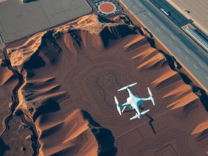
Utilizing cutting-edge drones equipped with advanced features like GIS integration and multispectral imagery enhances data precision while ensuring adherence to the relevant regulations.
The evolution of UAV technology continues to reshape the landscape and capabilities of aerial data collection, offering various services tailored to specific surveying requirements.
Click here to learn more about: contact
Understanding Aerial Surveying Compliance
Maintaining adherence to regulatory standards is paramount for successful projects utilizing unmanned aerial vehicles. Compliance encompasses following established guidelines from governing authorities, which serve to ensure both safety and project efficacy.
Understanding the distinct functions of various regulatory agencies is a fundamental aspect of these standards.
For example, although the Federal Aviation Administration (FAA) provides national regulations, local jurisdictions often implement additional rules that can affect UAV operations within their boundaries.
A prevalent issue encountered by aerial surveyors involves the nuances of airspace restrictions.
Many individuals may not be aware that no-fly zones can change rapidly, often due to temporary flight restrictions related to events or emergencies. Advanced technologies such as Lidar and photogrammetry facilitate data collection with increased accuracy.
Remaining compliant necessitates ongoing education regarding regulatory changes. Therefore, following aerial surveying standards not only enhances public safety but also cultivates trust within the aerial mapping sector.

Key Regulations For Drone Operations
The use of unmanned aerial vehicles in various sectors is governed by a comprehensive set of rules meant to ensure safety and compliance. The Federal Aviation Administration (FAA) is responsible for overseeing these legal frameworks, which categorize operations based on their intended applications.
For example, commercial operators must register their aircraft and fulfill specific licensing obligations, including obtaining a remote pilot certificate.
These certificates often require ongoing education to keep pace with changing laws and safety protocols, making adaptability a necessity in this evolving field.
Operators must also be mindful of operational constraints, such as altitude limits in urban environments, which affect the execution of aerial surveys.
Unique considerations come into play when employing drones for specialized applications, including construction and agricultural assessments. It’s important to recognize the significance of adhering to both federal and state rules, which can differ substantially.
A thorough understanding of these regulations not only supports safe practices but also enhances the effectiveness of aerial mapping and surveying initiatives.
Unmanned Aerial Vehicles Regulations
- The FAA oversees regulations for unmanned aerial vehicles to ensure safety and compliance in various sectors.
- Commercial operators are required to register their drones and obtain a remote pilot certificate, which involves ongoing education.
- Operators must adhere to altitude limits in urban areas to maintain safety during aerial surveys.
- Understanding both federal and state regulations is crucial as they can vary significantly, impacting operational effectiveness.
Importance Of Accurate Terrain Mapping
Effective mapping of land surfaces plays a pivotal role across numerous industries, influencing decision-making and resource allocation. UAV technology revolutionizes the ability to survey extensive areas with speed and precision.
Drones equipped with high-resolution cameras can capture imagery that significantly enhances the accuracy of analyses conducted by surveyors.
Unique to this approach, Lidar technology can penetrate dense vegetation, yielding accurate data in heavily forested regions where traditional methods often fall short.
Deploying UAVs allows for accessing difficult terrains without invasive equipment or large crews, which not only boosts operational efficiency but also minimizes costs. By obtaining accurate terrain information, industries can ensure compliance with relevant regulations while reducing their environmental footprint.
Thus, precise mapping is indispensable for planning and executing projects across diverse sectors, impacting areas ranging from agriculture to construction.
Best Practices For Aerial Photography
A successful aerial photography project relies on meticulous attention to multiple factors, which can significantly enhance clarity and overall visual quality. One important consideration involves the application of specialized sensor technology that improves image quality and captures intricate details with precision.
Effective pre-flight planning is paramount; mapping out designated flight paths can optimize coverage, particularly when surveying large areas.
Interestingly, many operators are unaware that software for real-time weather monitoring can mitigate risks associated with unpredictable conditions.
It is also advisable to optimize camera settings based on specific project needs, adjusting ISO and shutter speed to suit varying lighting environments. Compliance with necessary permit requirements is paramount, as this not only facilitates legal operation but also bolsters overall safety protocols.
Post-flight image processing techniques, including advanced photogrammetry, can convert collected data into detailed topographic maps, which significantly enhances the analysis of aerial imagery.
Transitioning from the importance of accurate terrain mapping, it is crucial to adhere to federal guidelines on UAV use, which govern the operational parameters for aerial photography. These regulations ensure that aerial surveyors operate within the legal framework, maintaining safety for both the operator and the public.
Understanding these guidelines provides insight into the responsibilities associated with using drones for mapping and surveying services.
| Factor | Importance |
|---|---|
| Specialized Sensor Technology | Improves image quality and captures intricate details |
| Pre-Flight Planning | Optimizes coverage for large areas |
| Real-Time Weather Monitoring | Mitigates risks associated with unpredictable conditions |
| Compliance with Federal Guidelines | Ensures legal operation and safety for operators and the public |
Federal Guidelines On UAV Use
Engagement with federal standards is important for individuals participating in drone operations. The Federal Aviation Administration (FAA) establishes regulations that promote safe usage of unmanned aerial vehicles and mitigate potential hazards.
Adhering to these compliance measures not only enhances project efficiency but also fosters a culture of responsibility among operators.
For example, the Part 107 regulations mandate that pilots obtain certification, underlining the necessity of having a solid foundation in aerial operations.
Specific types of surveys, such as aerial assessments, face limitations, including restrictions on flying over populated areas and the requirement to maintain a visual line of sight. Unique insights indicate that the process of acquiring waivers for beyond visual line of sight operations is influenced by an operator’s previous flight experience and the safety measures associated with the mission.
The registration requirement for unmanned aerial vehicles exceeding 55 pounds underscores the importance of remaining informed about compliance, particularly concerning best practices in the industry.
Ensuring Privacy In Drone Surveys
Privacy concerns arise in the context of aerial mapping and surveying, particularly when drone technology is employed in populated areas. UAVs often incorporate high-resolution sensors and cameras capable of capturing images and data that may inadvertently intrude into private domains.
To address these issues, various jurisdictions have established regulations outlining the scope of the survey to set clear boundaries regarding aerial reconnaissance.
Obtaining permits or approvals from relevant authorities prior to conducting drone operations is crucial to ensure compliance with local laws.
Engaging with community members further promotes transparency, helping to alleviate apprehensions surrounding unauthorized data collection. Advanced technologies, such as geofencing, enhance the ability to provide secure data collection by preventing drones from flying over sensitive locations.
Adhering to privacy regulations safeguards individual rights while allowing for efficient aerial surveying operations.
Privacy Concerns in Aerial Mapping
- High-resolution sensors on UAVs can capture detailed images that may invade personal privacy.
- Regulations in various jurisdictions help define the limits of aerial reconnaissance to protect private domains.
- Obtaining permits for drone operations is essential for compliance with local privacy laws.
- Technologies like geofencing can prevent drones from entering sensitive areas, enhancing data security.
The Role Of Technology In Surveying
Technological innovations have transformed the landscape of mapping and data collection. A noteworthy advancement is the use of drones, which are not merely equipped with cameras but also employ laser pulses to measure distances with remarkable precision.
These devices enhance the surveying process by generating detailed 3D models of terrains and vegetation, enabling professionals to perform complex analyses efficiently.
High-resolution imagery obtained from these aerial devices supports the mapping of sensitive information regarding land use and natural resources.
The operational efficiency of drone surveys allows access to hard-to-reach locations, significantly minimizing risks to personnel while expediting project timelines. The swift processing of the data collected provides project-specific insights that can vary depending on the requirements, contributing to improved decision-making.
As advancements in aerial technology continue, the applications for precise 3D mapping and data visualization are becoming increasingly diverse, enabling a wider range of industries, including construction and environmental monitoring, to benefit from these innovative practices. Maintaining privacy in drone surveys is crucial, and adherence to regulations is essential for responsible operation.
Essential Permits For Aerial Surveys
Obtaining the appropriate permissions for conducting aerial surveys is fundamental for ensuring project success. Operators utilizing unmanned aircraft for these operations must secure a range of necessary approvals, which vary based on local, state, and federal governance.
For instance, the Federal Aviation Administration (FAA) requires all commercial drone pilots to hold a Remote Pilot Certificate, a detail often disregarded by newcomers.
Having the right permits not only facilitates adherence to legal standards but also guarantees that the captured data meets required industry benchmarks.
Failure to comply with these guidelines can result in significant project delays and potential legal disputes.
Each locality may impose specific regulations, creating added layers of complexity in the permit acquisition process. A frequent oversight occurs in the realm of privacy concerns, as aerial imaging may inadvertently document private properties, possibly inciting disputes.
By thoroughly comprehending the importance of these permits, operators can better prepare for the nuanced demands of aerial surveying, while also expanding their capabilities to create maps for various purposes across diverse industries.
Aerial Surveying Vs Ground Surveying Drone Insights
Aerial Topographic Mapping Insights