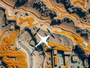
The rapid evolution of aerial technology has ushered in significant advancements in data collection methods. Drones have emerged as essential tools for gathering high-resolution imagery, facilitating the creation of comprehensive maps that intricately depict the terrain.
By merging multiple images into a singular, detailed representation, modern mapping services have greatly enhanced the accuracy of surveys while markedly reducing the time required for completion.
These unmanned vehicles can navigate difficult environments, offering access to areas that were previously challenging to survey.
Integration of advanced sensors, such as multispectral cameras, further elevates data quality by capturing details often missed in conventional aerial photography, including metrics related to vegetation health and soil composition. As various industries increasingly adopt this innovative approach, the capabilities of orthomosaic mapping continue to broaden, leading to improved decision-making across diverse sectors.
Click here to learn more about: contact
Aerial Surveys For Enhanced Mapping
The advent of technology in mapping has revolutionized how data is collected, particularly through the use of unmanned aerial vehicles (UAVs). These sophisticated aerial platforms enable comprehensive coverage of large areas while capturing intricate details of the land’s topography.
Various industries, including construction and real estate, benefit significantly from this innovation due to the superior accuracy achieved in data collection.
The advanced cameras mounted on UAVs are capable of high-resolution photographs, which uncover finer nuances that traditional methods may overlook.
For example, the integration of the Global Positioning System enhances the precision of the data acquired, facilitating more detailed analysis of both terrain and constructed features. The creation of orthophotos—geometrically corrected images—improves the reliability of visual data, making it invaluable for applications such as urban planning and environmental oversight.
As technologies continue to progress, the efficiency of these data collection methods improves, expanding their applicability and establishing them as indispensable tools in modern surveying practices.

The Benefits Of Orthomosaic Technology
The use of innovative imaging techniques has transformed how various industries approach data collection and spatial analysis. This advanced technology merges aerial imagery with sophisticated processing methods, resulting in precise and geometrically accurate orthomosaic visuals.
By capturing multiple aerial photographs and stitching them together, professionals can produce detailed representations that significantly reduce distortion often found in traditional photography.
Such accuracy enhances spatial analysis, proving invaluable for sectors like construction and agriculture.
For example, agricultural experts employ these images to monitor crop health and devise strategies to optimize yield potential. The integration of diverse data types, including Lidar, further enriches the analysis process, allowing stakeholders to make well-informed decisions grounded in multifaceted datasets.
Ultimately, the capabilities delivered by this technology signify a major advancement in aerial surveying, leading to more efficient and precise applications across multiple fields.
Innovative Imaging Techniques
- Advanced imaging techniques combine aerial imagery with processing methods for accurate orthomosaic visuals.
- These techniques significantly reduce distortion compared to traditional photography.
- Agricultural experts utilize these images to monitor crop health and optimize yield potential.
- The integration of diverse data types, such as Lidar, enhances analysis and decision-making processes.
High Resolution Images For Accurate Data
Utilizing advanced imaging techniques is pivotal for enhancing the reliability of data gathered in various sectors. High-quality visuals allow for meticulous analysis, surpassing the detail provided by traditional approaches.
For instance, aerial imagery obtained through state-of-the-art drones can yield up to 30 times more detail than standard photography methods.
Drones equipped with specialized sensors, including lidar, are integral in collecting these images, offering unmatched flexibility for detailed mapping services.
In agriculture and construction, high-resolution imagery plays a vital role in effective monitoring and planning. The integration of drone mapping software facilitates the swift processing of collected data, contributing to informed decision-making and enhancing project delivery.
Unique methodologies, such as orthomosaic mapping, reveal intricate details that conventional techniques often overlook, thereby revolutionizing spatial analysis and providing insights invaluable to multiple industries.
Streamlining Construction With Drone Services
Innovative approaches are reshaping the construction industry by significantly enhancing operational efficiency. Employing cutting-edge technology for data collection offers numerous advantages, particularly through the application of aerial imaging techniques on construction sites.
This method enables teams to produce detailed maps that increase planning accuracy.
For instance, when utilizing drone orthomosaic maps, a comprehensive image is created by stitching together a series of high-resolution images, providing an extensive overview of the project area.
This technology extends beyond mere visual representation; the combination of drone lidar and orthomosaic data collection techniques allows for meticulous spatial analysis. The integration of these technologies accelerates data acquisition processes and provides real-time updates, empowering construction teams to make informed decisions throughout the project’s lifecycle.
Such advancements in mapping technology are revolutionizing traditional methods and optimizing construction workflows.
High-resolution images sourced from drones not only enhance data quality but also contribute to precise land surveying practices. These visuals serve as fundamental components in the analytical processes that inform construction activities and resource management.
As the industry adopts these sophisticated tools, the reliance on outdated methodologies diminishes, paving the way for more efficient and effective practices in project execution.
The role of photogrammetry in aerial mapping further complements these advancements. By leveraging the principles of photogrammetric analysis, construction professionals gain additional insights into high-resolution aerial orthomosaic maps, detailed land surveying, and 3D models that enhance project planning and execution.
Innovative Approaches in Construction
- Aerial imaging techniques enhance planning accuracy through detailed maps.
- Drone orthomosaic maps provide comprehensive overviews by stitching high-resolution images.
- Integration of drone lidar and orthomosaic data allows for meticulous spatial analysis.
- Photogrammetry enhances project planning with detailed land surveying and 3D models.
Understanding Photogrammetry In Aerial Mapping
This innovative technique leverages high-resolution imagery for the analysis of the Earth’s surface, fundamentally altering the methods used in geographic data representation. By capturing aerial images and extracting precise measurements, professionals can develop detailed maps and models of various landscapes.
Although commonly linked to drone technology, the practice actually originated in the late 19th century, with early pioneers exploring photography’s potential for surveying purposes.
The evolution of advanced software has enhanced workflows significantly, facilitating the swift processing of aerial data collection.
A standout feature of this approach is its capability to create orthomosaic maps, merging multiple images into a cohesive, highly detailed representation of a geographic area. Such innovation serves multiple sectors, including construction and environmental monitoring, thereby improving decision-making processes across diverse industries.
As technological advancements continue, the relationship between drone images and aerial analysis is reshaping our understanding of geographic data in profound ways.
Elevation Models For Detailed Topography
Accurate terrain representation is significant for various applications, especially in mapping and analysis. These models facilitate the visualization of 3D mapping data, offering a detailed aerial perspective that traditional techniques may overlook.
Digital Elevation Models (DEMs) and models derived from LiDAR technology are prevalent in this field.
Uniquely, LiDAR can penetrate dense forest canopies, ensuring that ground elevations are accurately represented rather than merely theoretical.
High-resolution aerial imagery plays a crucial role in creating 2D orthomosaic maps. These maps are generated by stitching together multiple images captured by drones equipped with advanced sensors.
Each of these models serves distinct applications in urban planning and environmental management, illustrating the importance of precision in elevation data, which supports effective decision-making. As the technology advances, a greater emphasis on integrating drone mapping software enhances the accuracy and efficiency of these topographic models.
Accurate Terrain Representation
- Digital Elevation Models (DEMs) are essential for precise mapping in various applications.
- LiDAR technology can penetrate forest canopies, providing accurate ground elevation data.
- High-resolution aerial imagery is crucial for creating detailed 2D orthomosaic maps.
- Advancements in drone mapping software improve the accuracy and efficiency of topographic models.
Advanced Software In Drone Mapping
The integration of sophisticated tools into aerial surveying has transformed how data is collected and analyzed. By employing innovative techniques, professionals are able to create highly detailed maps that merge hundreds or thousands of aerial photographs.
This advanced technology enables the correction of camera tilt and lens distortion, ensuring clarity and precision in the final output.
These solutions provide real-time data processing capabilities, allowing for immediate analysis crucial in sectors like construction, where construction orthomosaic maps play an integral role in monitoring project status and resource allocation.
The ability to combine on-demand drone lidar and orthomosaic further enhances elevation models, offering accurate topographical insights. Continuous advancements in these tools are making them vital assets for various industries, facilitating effective decision-making and promoting competitive advantages.
Elevating Real Estate With Aerial Imagery
The use of aerial imagery has transformed the way properties are assessed and marketed within the real estate sector. Drones equipped with precise aerial technology capture images that reveal the entire scope of a property, including its surroundings and topography.
This capability allows for detailed assessments, which can significantly influence buyer decisions.
Data for various applications, including mapping and spatial analysis, is quickly gathered, enabling developers to visualize potential projects with greater clarity.
A notable advantage of utilizing survey-grade drones lies in their ability to create photogrammetrically orthorectified image products, ensuring high precision in measurements. These images enhance marketing strategies by offering potential buyers captivating views similar to platforms like Google Maps.
With ongoing advancements, the integration of such advanced aerial data into urban planning and environmental studies could fundamentally alter how properties are evaluated and developed.
Aerial Imagery in Real Estate
- Drones provide comprehensive views of properties, including their surroundings and topography.
- Survey-grade drones can create highly accurate orthorectified image products for precise measurements.
- Aerial imagery enhances marketing strategies by offering engaging visuals similar to Google Maps.
- Advanced aerial data integration can transform urban planning and environmental studies.
Volumetric Analysis Aerial Surveys Stockpile Secrets Unveiled
Aerial Lidar Surveying Services Precision Mapping With Keystone Aerial