The visualization of spatial information has undergone significant transformation due to advancements in modern techniques. Utilizing a combination of aerial photography and Lidar, professionals can create precise three-dimensional representations of terrain and structures.
A notable feature of contemporary software designed for this process is its capacity to analyze extensive data sets expediently, enabling real-time modifications during field operations.
Unmanned aerial vehicles play an instrumental role, capturing high-resolution images from locations that may otherwise be inaccessible.
This innovative approach streamlines traditional surveying methods, resulting in shorter project timelines. An intriguing aspect of integrating 3D computer graphics is its power to enhance the interpretation of intricate data, facilitating clearer communication among stakeholders.
These technological developments significantly improve decision-making across various sectors, including construction and environmental monitoring, by providing detailed and actionable insights.
Click here to learn more about: contact
The Benefits Of 3D Mapping
Utilizing advanced technologies to capture and analyze spatial data has transformed numerous industries. Aerial imaging from drones offers exceptional resolution, outperforming conventional methods in both speed and precision.
This innovative approach employs photogrammetry, facilitating the conversion of two-dimensional images into intricate three-dimensional representations.
Operating in hard-to-reach terrains, these unmanned aerial vehicles (UAVs) gather geographic information that is often difficult to obtain through traditional surveying techniques.
The sophisticated software used in processing this data minimizes human error, enhancing reliability throughout the mapping process. In the construction sector, these detailed visualizations assist in more effective planning and resource management.
By integrating building information modeling, stakeholders can explore complex architectural projects digitally before actual construction begins, leading to streamlined execution. The combination of advanced aerial imagery and automated data analysis significantly influences how industries manage information and make informed decisions.

How 3D Mapping Enhances Visualization
The innovative application of aerial technology transforms how complex data is visualized, leading to improved interpretability of geographic information. Drones equipped for surveying can capture high-resolution imagery and data in a remarkably efficient manner.
This capability results in the development of comprehensive 3D maps, effectively illustrating intricate terrains and infrastructures.
Such detailed representations facilitate the identification of patterns and anomalies, often obscured by traditional visualization methods.
Unique advancements within the United States, particularly in sensor integration, such as Lidar and photogrammetry, significantly enhance the accuracy of collected data. These techniques also allow for real-time updates, a factor that is particularly valuable for engineering projects where prompt decision-making can determine success.
As industries expand their use of 3D mapping technology, recognizing its potential benefits becomes increasingly important for applications ranging from environmental monitoring to urban planning.
Aerial surveys utilizing drones specialize in providing precision mapping services tailored to diverse project needs. The ability of UAVs to access challenging terrains allows for efficient data acquisition and analysis.
High-resolution imagery not only complements data collection but also enriches understanding through visual context.
Various UAV data collection methods, including multispectral imaging, strengthen the capabilities of mapping technologies, yielding valuable insights for sectors such as construction, agriculture, and real estate. Collaboration with professionals in these fields enhances the accuracy of simulation and 3D mapping technology, ultimately leading to more efficient energy use in critical infrastructure across the United States.
Exploring 3D Mapping Software Options
Effective spatial visualization tools are increasingly important in various industries, providing a significant edge in data collection and analysis. Specialized software enables the integration of aerial imagery and Lidar data, leading to improved accuracy in gathering information.
Advanced algorithms are instrumental in generating detailed 3D models, which facilitate more informed decision-making processes.
Utilizing drone technology for mapping allows for swift data acquisition, particularly in locations that are difficult to access.
Remarkably, many are unaware that such innovations can drastically cut down the time typically required for conventional site surveys. The combination of GIS mapping technologies with these applications enhances spatial analysis, providing users with deeper insights.
Intuitive interfaces within these platforms simplify the execution of complex tasks, making them more accessible to diverse users. As these software options evolve, they continue to significantly transform how industries visualize and interpret geographical information.
Transitioning from the enhancement of visualization, it is essential to recognize the pivotal role drones play in 3D mapping.
The Role Of Drones In 3D Mapping
Utilizing unmanned aerial vehicles to gather data has revolutionized how professionals approach spatial analysis and project planning. Drone mapping is the process of employing these devices to capture high-resolution images and collect data efficiently, which enhances the capabilities of traditional surveying techniques.
Its advantage lies in the ability to survey expansive areas swiftly, significantly reducing costs associated with fieldwork and labor.
Advanced sensors, such as Lidar and multispectral imaging, facilitate the gathering of detailed 3D information, resulting in depth and accuracy that were previously difficult to achieve.
Drones are particularly effective in surveying challenging terrains, where access for ground crews may be restricted. Their applications range widely, from real estate developments to environmental monitoring, offering real-time insights into spatial relationships.
As technology continues to advance, the tools used in this field will likely see enhancements in efficiency and utility, further solidifying their role as indispensable resources across various sectors.
Drone Mapping
- Drones can survey large areas quickly, reducing fieldwork costs by up to 50%.
- Advanced sensors like Lidar can capture 3D data with a precision of up to 1 centimeter.
- Drone technology is effective in hard-to-reach terrains, improving data collection in challenging environments.
- Applications of drone mapping include sectors such as real estate, agriculture, and environmental monitoring.
Effective Techniques For 3D Reconstruction
Creating detailed representations of physical objects or landscapes involves various sophisticated methods. Among the most effective techniques is photogrammetry, which 3D mapping requires the profiling of overlapping images captured from multiple angles.
This technique has significantly evolved, particularly with the advent of modern drone technology, enhancing precision in mapping through high-resolution image capture.
Another prominent method is Lidar, which employs laser scanning to gather meticulous distance measurements, capable of penetrating dense vegetation for accurate mapping of forested areas.
Point cloud generation converts raw data into three dimensions to map extensive regions, facilitating enhanced spatial analysis. The integration of techniques such as mesh generation can also create 3D effects by detecting intricate details often overlooked by traditional imaging methods.
Utilization of aerial survey technologies is indispensable across various sectors, including construction and environmental monitoring, where drones are increasingly employed for efficient topographic mapping and data collection. As these techniques continue to evolve, they promise improved accuracy and efficiency in an array of applications.
Understanding Geographic Information Systems
Geospatial analysis is revolutionizing how data is mapped and interpreted across various fields. Geographic Information Systems (GIS) integrate diverse types of data, enhancing the precision of spatial analysis beyond traditional techniques.
A noteworthy feature of this software is its compatibility with drone mapping software, which enables rapid and efficient data collection through aerial surveys.
High-resolution imagery captured via drones is increasingly vital in sectors such as construction and agriculture, where detailed visual context significantly aids in decision-making.
Drones and drone mapping software are used for remote sensing applications, facilitating accurate topographic mapping and comprehensive spatial analysis.
Unique functionalities of GIS extend to environmental monitoring, providing meaningful insights for land management decisions. The integration of aerial data enhances project timelines by streamlining the collection process, particularly in complex geographic regions.
As a transformative tool, GIS exploits technology to optimize resource management and enable informed decision-making in various applications. This synergistic approach underscores the importance of modern technology in effective mapping and surveying practices.
Geospatial Analysis
- Geographic Information Systems (GIS) enhance spatial analysis accuracy by integrating diverse data types.
- Drone mapping software allows for rapid data collection through aerial surveys, significantly improving project timelines.
- High-resolution imagery from drones is essential in sectors like construction and agriculture for informed decision-making.
- GIS supports environmental monitoring, providing valuable insights for effective land management.
Key Applications Of 3D Mapping In Construction
As construction methodologies evolve, the integration of advanced mapping techniques becomes increasingly important for project efficiency. One significant application is enhanced site planning, where accurate dimensions help teams visualize the relationship of various objects in relation to existing structures.
Utilizing detailed projections, teams can map and identify possible obstructions before ground-breaking, minimizing costly delays.
In addition to planning, 3D digital mapping facilitates progress monitoring.
Stakeholders can employ aerial imagery to collect valuable data from project sites, allowing for a comparison between modeled designs and the evolving reality on the ground. This method not only boosts project transparency but also enhances communication among various teams.
The combination of 3D visualization with other technologies such as GIS and BIM leads to more informed decision-making. By providing a realistic view of a site’s dimensions, advanced mapping techniques improve the overall management of construction projects.
Aerial surveys utilizing drones significantly contribute to this process, capturing high-resolution images that inform spatial analysis and topographic mapping.
The use of UAVs and their ability to reach challenging areas supports a more comprehensive understanding of construction sites, further emphasizing the myriad benefits offered by these technologies.
Innovations In 3D Visualization Technology
Recent advancements in technology are revolutionizing how industries approach visual data representation. Aerial mapping, utilizing drones equipped with sophisticated sensors, facilitates the creation of reliable three-dimensional models.
These models arise from techniques such as photogrammetry and Lidar, which deliver precise and actionable data essential for effective project planning.
Interestingly, detailed maps produced through these methods can uncover features invisible to the naked eye.
For example, UAVs are capable of capturing thermal data, which can identify areas of heat loss in buildings; this aspect plays a significant role in assessing energy efficiency. Software tools like Autodesk Forma streamline the integration of various three-dimensional data types into project workflows, thereby fostering enhanced collaboration among involved parties.
The trajectory of mapping technology is promising, with ongoing innovations ensuring that aerial services lead the way in spatial analysis and decision-making across construction and various other sectors.
Aerial Mapping Technology
- Drones equipped with sensors can create reliable three-dimensional models through photogrammetry and Lidar techniques.
- Thermal data captured by UAVs can identify heat loss areas in buildings, aiding in energy efficiency assessments.
- Software tools like Autodesk Forma enhance collaboration by integrating various three-dimensional data types into project workflows.
- Ongoing innovations in aerial mapping technology are leading to improved spatial analysis and decision-making in construction and other sectors.
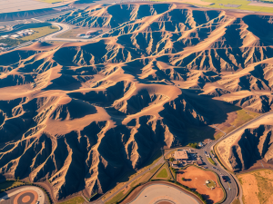
LiDAR Survey Developments Drones Transform Mapping
Aerial Photography Techniques Stunning Drone Shots