The integration of modern technology has transformed various sectors, leading to groundbreaking advancements in measurement and representation.
Unmanned aerial vehicles have dramatically enhanced the capability to capture high-resolution images from above, producing detailed maps with unmatched accuracy.
Advanced mapping software improves the efficiency of data collection, enabling surveyors to create precise topographical representations.
Lidar technology offers a deeper insight into the landscape, revealing features that might otherwise go unnoticed.
This innovative approach not only accelerates the surveying process but also significantly reduces costs, making it an attractive option for multiple sectors
Innovative Uses Of Drones In Surveying
The utilization of advanced technology has transformed traditional data collection methods. Equipped with sophisticated sensors, aerial vehicles facilitate precise measurements across expansive landscapes.
Utilizing high-resolution imagery from aerial photography, professionals enhance the accuracy of their findings and significantly improve workflow efficiency.
Within sectors such as construction, real-time information gathered during flights aids seamless project management.
This cutting-edge technology diminishes expenses while amplifying productivity, granting surveyors access to detailed insights for their undertakings. As various industries increasingly adopt this technological advance, the potential applications seem boundless.

Enhancing Accuracy With Drone Technology
Precision in data collection is becoming increasingly significant as industries adapt to new challenges. The integration of advanced imaging techniques enhances the reliability of information gathered from aerial perspectives.
Utilizing a geographic information system along with drone surveys enables professionals to gain a comprehensive view of terrain features.
Real-time data processing greatly improves decision-making processes, particularly within agriculture and infrastructure development sectors.
As efficiency improves, these aerial technologies deliver valuable insights applicable in various fields, including building information modeling and health monitoring. The evolution of these methodologies suggests a promising future for advancements in accuracy.
| Technology | Impact |
|---|---|
| Advanced Imaging Techniques | Enhances reliability of aerial data |
| Geographic Information Systems | Provides comprehensive terrain analysis |
| Drone Surveys | Facilitates real-time data processing |
| Aerial Technologies | Offers valuable insights for multiple fields |
Transforming Mapping Through Aerial Data
The evolution of how we gather geographic information has opened new pathways for precision and efficiency. With advanced technologies, surveyors can now utilize drones to capture extensive data with remarkable clarity.
This approach enhances the capability of mapping software to create intricate 3D models for diverse applications.
By employing sensor integration alongside ground control points, the process of land surveying experiences significant reductions in both time and costs.
Examining the benefits of this advancement reveals a trend toward increasingly accurate data collection techniques. As we transition into the realm of multispectral imaging, we uncover further insights into agricultural practices and their optimization.
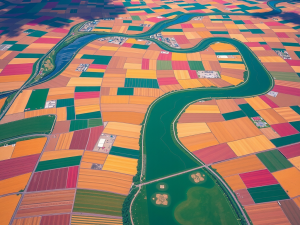
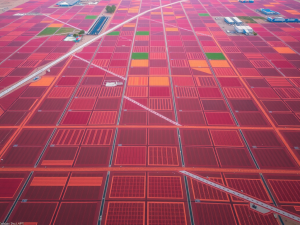
Multispectral Imaging For Agriculture Insights
Precision farming utilizes innovative technologies to enhance agricultural productivity. Aerial images offer a unique perspective on crop health, soil conditions, and overall performance.
By capturing wavelengths beyond the visible spectrum, these methods allow for insights that were once unattainable.
With a comprehensive understanding of their fields, producers can make informed decisions that optimize yield.
The capability to collect data supports efficient resource management, paving the way for sustainable agricultural practices. The future looks promising as advancements in drone mapping software continue to refine these processes.
Precision Farming
- Aerial imaging can detect crop health issues before they are visible to the naked eye.
- Precision farming techniques can lead to a yield increase of up to 20% in some crops.
- Data collection through drones reduces resource waste, saving farmers up to 30% on inputs.
- Advancements in drone technology are expected to enhance the accuracy of agricultural assessments.
Elevation And Terrain Analysis With UAVs
Emerging technologies are significantly transforming the ways we collect and analyze geographic data. Utilizing UAVs facilitates enhanced precision when surveying expansive terrains, providing an unparalleled perspective on features across the landscape.
The efficiency of capturing detailed topographic surveys allows project timelines to shrink, significantly benefiting professionals engaged in various sectors.
High-resolution survey data acquired through drone imagery ensures comprehensive insights, enabling applications across industries such as construction and environmental monitoring.
Further integration of photogrammetry software amplifies the capabilities of these innovative surveying methods, paving the way for more effective analysis. Transitioning from earlier techniques, the evolving landscape of digital elevation models reflects the remarkable potential inherent in drone technology.
The Future Of Digital Elevation Models
Innovation in geospatial technology is poised to transform our approach to environmental interactions.
Significant advancements in surveying with drones are already paving the way for more accurate mapping techniques.
For instance, drones equipped with high-resolution cameras are now capturing detailed terrain data.
This data can enhance environmental monitoring and support urban planning efforts.
These models can be updated in real-time, allowing for surveying projects that adapt quickly to changing conditions.
As we embrace these innovations, questions arise about the implications for decision-making and resource management, especially as we transition from elevation and terrain analysis with UAVs to streamlining construction projects with drone surveys
Streamlining Construction Projects With Drone Surveys
Technology’s role in transforming project management is increasingly significant, introducing innovative methods to enhance efficiency. Utilizing drone surveying increases the accuracy of site evaluations, facilitating comprehensive topographic surveys for land management.
With aerial views, teams can capture detailed site information far more quickly compared to manual surveying practices.
This rapid acquisition of reliable data enables consistent progress monitoring, keeping stakeholders updated throughout the project lifecycle.
Commercial drones can help lower costs associated with project delays while enhancing safety on construction sites, establishing an upgraded standard in execution. Transitioning from traditional methods to this modern surveying solution sets the foundation for significant advancements in how projects are realized.
Aerial Photography S Role In Modern Mapping
The integration of innovative imaging technology into the mapping process has transformed how data is collected. Utilizing advanced tools, professionals can collect aerial images with unmatched precision, enabling them to effectively survey large areas.
Drones can carry various cameras and sensors, providing detailed visual data that significantly enhances decision-making processes.
Through specialized software, this information can be analyzed and integrated into existing mapping frameworks, ensuring a comprehensive understanding of the terrain.
The rapid coverage offered by drones proves invaluable for pre-construction engineering studies, where efficiency and accuracy remain paramount. Transitioning from traditional surveying methods to this modern approach not only streamlines workflows but also elevates project outcomes.
Innovative Imaging Technology in Mapping
- Drones provide aerial images with unmatched precision for large area surveys.
- Advanced cameras and sensors on drones deliver detailed visual data for enhanced decision-making.
- Specialized software allows for the analysis and integration of collected data into existing mapping frameworks.
- The rapid coverage of drones is essential for efficient and accurate pre-construction engineering studies.