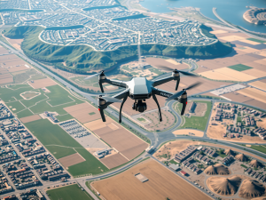
Recent advancements in imaging technology are revolutionizing data collection across various sectors. Drones equipped with high-resolution cameras offer capabilities that surpass those of traditional surveying tools, allowing for real-time capture of images even in remote locations.
These devices can easily maneuver around obstacles such as dense forests or steep cliffs, presenting data that ground surveys often struggle to collect.
For instance, the integration of infrared sensors into these units allows for the identification of temperature variations, which is vital for tasks like environmental monitoring.
The United States has emerged as a leader in the deployment of this technology, facilitating enhanced operational efficiency in construction and agricultural industries. Aerial imaging techniques notably decrease the time and costs associated with conventional surveying methods, leading to improved project accuracy and better resource management decisions.
UAVs utilize various data collection methods, including Lidar and photogrammetry, to provide comprehensive spatial analysis tailored to specific project needs.
Click here to learn more about: contact
Understanding Aerial Perspectives
The advent of aerial surveying has significantly transformed how data is gathered and interpreted, employing cutting-edge technology to produce intricate visual representations. Drones, also known as unmanned aerial vehicles (UAVs), have redefined traditional mapping approaches by acquiring high-resolution photographs from vantage points that were once inaccessible.
This innovative capacity enables precise detailing and effective monitoring of extensive regions, a process that was previously labor-intensive and costly when conducted from the Earth’s surface.
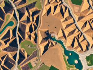
The practice of capturing aerial images finds utility in diverse fields, including environmental assessments, where it facilitates the evaluation of land use and alterations over time.
UAVs boast the ability to survey locations that pose hazards to human surveyors, thereby enhancing both safety and operational efficiency. The role of aerial imagery extends into contemporary cartography, wherein the merger of such data with geographic information systems (GIS) allows for improved spatial analysis, thus providing essential information for informed decision-making.

The Evolution Of Imaging Technology
Technological advancements have significantly reshaped the field of data collection and analysis, particularly in the realm of imaging. The emergence of aerial imaging solutions has addressed the limitations of traditional methods, offering precise mapping and data acquisition from elevated perspectives.
This transformation gained momentum in the mid-20th century with the advent of satellite photography, paving the way for drones to revolutionize the industry.
UAVs excel in capturing high-resolution aerial photographs, facilitating comprehensive analysis over expansive areas in a fraction of the time once required.
Innovative sensors, including Lidar and multispectral cameras, greatly enhance these capabilities, providing critical insights into vegetation health and topographical variations. Such advancements not only bolster accuracy but also expand the potential applications across diverse sectors, including construction, agriculture, and disaster management.
As technology progresses, the integration of artificial intelligence stands to further improve data processing and usability, promising a more refined approach to aerial data collection.
These developments exemplify the shift in focus towards aerial perspectives, emphasizing the importance of utilizing UAV mapping techniques for enhanced spatial analysis. The efficient methodologies adopted in aerial surveying allow for better decision-making and resource management in various industries, particularly construction and environmental monitoring. The rise of drone services has made it possible to access previously hard-to-reach areas, thereby unlocking new opportunities for detailed topographic mapping through aerial photography and advanced aerial imaging technology, which enhances elevation data collection and archives valuable aerial images.
Aerial Imaging Advancements
- UAVs can capture high-resolution aerial photographs, significantly reducing the time needed for data acquisition.
- Innovative sensors like Lidar and multispectral cameras enhance data collection, providing insights into vegetation health and topography.
- Aerial imaging technologies facilitate improved decision-making and resource management across industries such as construction and agriculture.
- The integration of artificial intelligence in aerial data processing promises a more refined approach to data usability and analysis.
Benefits Of Aerial Photography
The use of high-altitude imaging techniques has transformed our approach to data gathering and analysis. Employing drones, this innovative method captures high-resolution images that can offer valuable insights across multiple sectors, from construction to agriculture.
An intriguing aspect of this technology is its ability to enhance environmental monitoring by utilizing geospatial information to observe subtle land use changes over time.
Drones are particularly adept at reaching terrains where traditional surveying methods may falter, leading to more efficient data collection processes.
The incorporation of multispectral imaging allows for intricate analyses that are beneficial for assessing crop health. This method not only streamlines workflows by covering vast areas in a single flight but also contributes to significant reductions in time and labor costs.
In the real estate market, striking aerial imagery can elevate property listings, enhancing visibility and expediting sales. Such advancements highlight the multifaceted benefits associated with the implementation of aerial photography in various applications.
Exploring Remote Sensing Methods
Innovative techniques have transformed the collection and analysis of data from the Earth’s surface, revealing insights that are often hidden from direct observation. For instance, lidar technology excels by mapping terrain and vegetation through laser pulses emitted from airborne platforms.
This method provides high-resolution aerial imagery, capturing intricate details that traditional surveying may overlook.
Unique sensors can discern subtle land cover variations, which are essential for environmental assessments and land use planning.
Multispectral imaging, a notable technique, evaluates crop health by analyzing light reflected at various wavelengths, opening avenues for precision agriculture. Timely information derived from these methods is instrumental during disaster response, offering vital geospatial data that enhances situational awareness.
The adaptability of these technologies plays a pivotal role as diverse industries increasingly depend on advanced methods for accurate data collection and effective decision-making.
The transition to aerial surveys highlights the efficiency of drone technology, which can access challenging terrains while capturing high-resolution images and data. UAV mapping techniques simplify topographic mapping and spatial analysis, leading to significant time and cost reductions.
Diverse applications span construction, agriculture, mining, and real estate, where aerial photography complements surveying by providing visual context. Among the tools in this digital arsenal, lidar, photogrammetry, and multispectral imaging stand out for their effectiveness, making aerial and satellite data crucial across various sectors, including geography, environmental monitoring, and urban planning, where cutting-edge drone technology and high-resolution aerial imagery from platforms like Hexagon enhance our understanding of shoreline changes and market trends.
Innovations In Aerial Data Collection
Technological advancements are fundamentally transforming how data is captured from above, leading to significant improvements across various sectors. Recent developments, particularly in UAV technology, have made it possible to acquire high-resolution imagery with remarkable accuracy and efficiency.
Drones outfitted with specialized sensors such as Lidar and multispectral cameras can gather geospatial data rapidly, surpassing the capabilities of conventional surveying methods.
This enhances the precision of topographic mapping and supports superior spatial analysis.
Interestingly, color-infrared aerial photographs can uncover vegetation health indicators, revealing details that often elude the naked eye. The incorporation of artificial intelligence in processing analytics further streamlines the conversion of raw data into actionable insights.
These innovative collection solutions have become indispensable in industries, including construction and agriculture. The utilization of aerial vehicles not only revolutionizes the process of gathering information but also opens avenues for new applications that significantly improve project effectiveness.
Applications Of Aerial Imagery
Utilizing aerial perspectives opens up a vast array of advanced techniques, particularly in the realm of data collection and analysis. For instance, UAVs enable real-time monitoring across extensive square miles, contributing to timely and precise project adjustments in construction.
High-resolution images captured during these flights allow teams to evaluate site conditions meticulously, leading to the implementation of stricter safety measures.
Environmental monitoring benefits from remote sensing technologies, including infrared imaging, which detects subtle changes in habitat health.
These insights inform conservation strategies aimed at protecting vulnerable ecosystems. In agriculture, multispectral analysis enhances assessments of crop vitality, significantly improving yield predictions and reducing the labor intensity typically associated with field scouting.
Drones automate these processes, allowing for more efficient data collection.
Real estate sectors leverage aerial views for compelling visualizations that showcase properties in ways that traditional ground-level photography cannot achieve.
Mining companies also utilize aerial surveys to map mineral deposits, enhancing efficiency and promoting sustainable resource management practices.
The versatility of UAV applications continues to influence various sectors, enabling improved data collection and informed decision-making.
Transitioning from these innovations, the ongoing advancements in geospatial technology promise even greater capabilities and applications in the future.
| Application Area | Benefits |
|---|---|
| Construction | Real-time monitoring for precise project adjustments |
| Environmental Monitoring | Infrared imaging detects changes in habitat health |
| Agriculture | Multispectral analysis improves yield predictions |
| Real Estate | Aerial views provide compelling property visualizations |
The Future Of Geospatial Technology
Technological advancements are reshaping how geographical data is collected and utilized. The rise of drones and UAVs has led to remarkable enhancements in topographic mapping, with these devices capturing high-resolution photographs that significantly refine survey accuracy.
The transition from traditional film cameras to advanced aerial imaging methods has accelerated survey timelines, enabling professionals to convert datasets into actionable insights more efficiently.
Artificial intelligence is increasingly being integrated into these processes, optimizing data processing capabilities and improving models for environmental monitoring and resource management.
Blockchain technology is emerging as a means to ensure the integrity and secure sharing of geospatial data. These innovations are set to impact various sectors, offering deeper understanding of environments and conditions, particularly in construction and agriculture.
Building on the applications of aerial imagery, the use of drones provides unique advantages for capturing detailed data that informs significant decision-making in numerous fields.
For instance, UAVs can reach areas that are difficult for traditional surveying methods to access, ensuring comprehensive coverage. This capability is especially beneficial in environmental monitoring, where real-time data collection supports effective resource management and conservation efforts.
Aerial imagery not only complements topographic surveys but also enriches the visual context necessary for detailed spatial analysis.
As the technology around UAVs continues to evolve, so will the potential for enhanced data analysis across various industries.
.
Aerial Imagery In Environmental Monitoring
The utilization of advanced imaging techniques fundamentally transforms the assessment of ecological conditions, particularly in hard-to-reach areas. This technology enables the collection of intricate data that enhances measurement systems used in environmental research.
Drones equipped with advanced airborne sensors can capture high-resolution photographs taken from various angles, which facilitates precise evaluations of land and vegetation.
A remarkable application involves the use of multispectral imaging, allowing experts to identify subtle changes in vegetation health that remain invisible to the naked eye.
Contrary to popular belief, this technique is vital for monitoring plant health indicators, proving invaluable for effective resource management. Aerial surveys significantly decrease the duration of assessments, often delivering results in a fraction of the time compared to conventional methods.
This efficiency not only promotes accuracy and detail but also leads to cost-effectiveness, particularly in extensive projects where ongoing monitoring is imperative. As the demand for innovative mapping techniques expands, their applications across sectors such as urban planning and conservation will undoubtedly highlight their increasing significance in contemporary environmental strategies.
Advanced Imaging Techniques in Ecology
- Drones with airborne sensors capture high-resolution images for detailed land and vegetation assessments.
- Multispectral imaging detects changes in vegetation health that are not visible to the naked eye.
- Aerial surveys significantly reduce assessment time, providing quicker results than traditional methods.
- Innovative mapping techniques are increasingly used in urban planning and conservation efforts.
GIS Mapping Trends 2024s Unique Path
Surveying With Drones A Fresh Take