The use of modern technology has significantly reshaped the landscape of land surveying, enabling quicker and more precise methods for data collection. Unlike traditional techniques, which can require extensive time to cover large territories, aerial systems can accomplish similar objectives within mere hours.
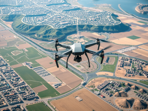
This remarkable speed is largely attributable to the advancements in Unmanned Aerial Vehicles (UAVs), which are capable of capturing high-resolution images from multiple perspectives.
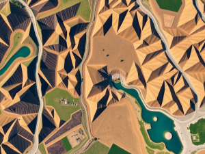
An intriguing application in this field is the implementation of multispectral imaging; this technique allows surveyors to assess land vitality and soil conditions by gathering data that extends beyond the visible spectrum.
By utilizing a variety of sensors, these aerial devices enhance the accuracy and depth of the information collected. The benefits of such technology are twofold: not only does it streamline decision-making processes, but it also substantially cuts down costs associated with conventional surveying practices.
3D mapping derived from aerial data offers an intricate viewpoint that plays an essential role in strategic planning across various sectors, including construction and agriculture.
Click here to learn more about: contact
Understanding Aerial Surveying Methods
Advanced surveying techniques utilizing unmanned aerial vehicles (UAVs) enable precise topographic mapping and data visualization. Drones equipped with high-resolution cameras and various sensors can capture intricate details of the landscape, facilitating accurate analysis.
For example, Lidar technology allows for depth penetration through dense forest canopies, providing an accurate model of underlying terrain that is often underestimated in environmental assessments.
This sophisticated method significantly enhances construction planning by delivering reliable geospatial data.
Aerial photography serves as a complementary tool, offering visual representation to reinforce data interpretation. The integration of Global Positioning System (GPS) technologies ensures the accuracy of spatial data, thus transforming the quality of topographic representations.
Industries such as agriculture, mining, and real estate are increasingly adopting these aerial survey techniques, gaining valuable insights for project planning and resource management while optimizing operational efficiency. As the technology continues to evolve, the applications of UAV mapping expand, delivering tailored services that cater to specific surveying needs.

The Role Of Drones In Land Mapping
Technological advancements have revolutionized the methodologies used in topographical assessment. Unmanned aerial vehicles (UAVs) facilitate rapid data gathering, allowing access to challenging terrains that would otherwise hinder traditional surveying practices.
These aircraft are capable of operating at various altitudes, enabling them to capture high-resolution imagery essential for detailed analysis.
Utilizing advanced techniques such as Lidar and photogrammetry, these systems generate digital elevation models that illustrate the surface characteristics with impressive fidelity.
The resulting point clouds provide critical information for geographic information system (GIS) applications, significantly enhancing spatial analysis. Project timelines are greatly reduced, promoting more effective urban planning and environmental evaluations.
The adaptability of UAVs allows for the integration of a range of sensors, including thermal and multispectral options, which enrich the data collected during each mission while ensuring adherence to regulatory standards, a necessity for commercial operations. With ongoing enhancements in UAV technology, the accuracy and effectiveness of land mapping continue to progress.
UAVs in Topographical Assessment
- UAVs enable rapid data collection in challenging terrains, improving surveying efficiency.
- High-resolution imagery captured by UAVs is essential for creating detailed digital elevation models.
- Advanced techniques like Lidar and photogrammetry enhance the fidelity of surface characteristic representations.
- The integration of various sensors, such as thermal and multispectral, enriches data collection while meeting regulatory standards.
Elevating Accuracy With Advanced Technology
Innovations in technology are reshaping the methodologies used for land assessment and data collection. The introduction of drone systems has made it possible to conduct aerial surveys with an unprecedented level of detail and speed.
Utilizing these aerial vehicles allows surveyors to access challenging terrains, which traditionally posed difficulties for conventional surveying methods.
Drones equipped with advanced sensors can capture high-resolution images, significantly enhancing image resolution and allowing for improved georeferencing in mapping projects.
This high-quality output is crucial for creating detailed topographic maps that serve a multitude of industries including agriculture, construction, and environmental monitoring. A particularly notable feature of drone mapping is the use of multispectral imaging, which enables the assessment of land features by analyzing vegetation health across varying wavelengths.
As technology continues to progress, it consistently provides innovative solutions that elevate the standards of precision and efficiency in surveying practices.
Exploring 3D Mapping Benefits
Innovative technologies are reshaping how spatial environments are perceived and analyzed. Utilizing unmanned aerial vehicles (UAVs) for mapping transforms raw data into interactive visual formats, enhancing traditional surveying methods through the creation of detailed point clouds.
This approach allows for rapid coverage of extensive areas, often leading to significant reductions in project timelines.
A less recognized aspect of this technology is the use of drones equipped with multispectral sensors, which can deliver valuable insights into vegetation health—an important factor in agricultural assessments.
These advanced tools not only collect data but also refine measurement precision, facilitating informed decision-making across various industries. The integration of mapping software with aerial imagery enables sophisticated layering of survey data, which is essential for comprehensive analysis and planning.
As the surveying industry continues to evolve, it becomes increasingly important for professionals to adopt effective strategies that optimize drone operations. Effective planning for aerial surveys can significantly enhance the quality and efficiency of data collection, ensuring that the benefits of this technology are fully realized.
| Technology | Benefits |
|---|---|
| Unmanned Aerial Vehicles (UAVs) | Transform raw data into interactive visual formats |
| Multispectral Sensors | Provide insights into vegetation health |
| Mapping Software Integration | Facilitates comprehensive analysis and planning |
| Effective Planning for Aerial Surveys | Enhances data collection quality and efficiency |
Effective Drone Flight Planning Tips
Planning a successful flight requires careful consideration of various elements that can influence UAV operations. Many individuals overlook the importance of pre-flight assessments, which can help identify potential obstacles and ensure adherence to local regulations.
Weather conditions significantly impact both safety and data quality during the operation, and terrain challenges must also be taken into account.
Selecting the appropriate drone type for the task is imperative, as not all UAVs are tailored for every surveying application.
For example, certain models are optimized for 3D mapping, while others may specialize in multispectral imaging, catering to different project requirements. Implementing efficient flight paths that utilize overlapping techniques can enhance coverage and detail, a fact often ignored in casual planning.
After completing the flight, employing advanced surveying software becomes crucial for converting raw drone survey data into actionable insights, facilitating better decision-making and maximizing cost savings achieved through strategic planning.
Essential Software For Drone Mapping
The utilization of specialized software is paramount for optimizing the capabilities of unmanned aerial vehicles (UAVs) during aerial data collection. Such solutions are fundamental for processing the vast quantities of information gathered through drone surveys.
Advanced features, including photogrammetry, enable users to construct accurate three-dimensional models and visual representations.
For instance, software like Pix4D empowers users to extract insightful data from drone imagery, while DroneDeploy facilitates streamlined project planning in various surveying applications.
Tools such as Agisoft Metashape offer distinctive analysis functions, enhancing the surveying process. The synergistic combination of these software solutions fosters enhanced data precision, which is vital for successful project execution.
As developments continue in drone technology, software for surveying and mapping evolves, further improving the efficiency and accessibility of data collection.
UAV Data Collection Software
- Specialized software is essential for processing large volumes of data collected by UAVs.
- Photogrammetry features allow for the creation of accurate 3D models from drone imagery.
- Software like Pix4D and DroneDeploy enhance data extraction and project planning in surveying.
- Continuous advancements in drone technology lead to improved surveying and mapping software capabilities.
Innovations In Surveying Techniques
Recent developments in data collection methods have significantly reshaped how professionals approach land analysis. Aerial surveying, utilizing drones, presents unique advantages compared to conventional approaches.
For example, a drone can quickly cover extensive terrains, capturing high-resolution images and data in a fraction of the time needed for traditional land surveying methods.
The integration of modern drone technologies, such as Lidar and photogrammetry, facilitates precise terrain analysis and 3D mapping, greatly enhancing data accuracy.
Utilizing drone surveying provides substantial cost savings by reducing the requirement for extensive manpower and equipment usually associated with traditional land surveying projects. Notably, advanced mapping software allows for efficient processing of aerial footage, transforming raw data into actionable insights.
This blend of speed, precision, and affordability positions UAVs as essential tools in contemporary surveying practices, driving innovations in the field.
The Future Of Aerial Data Collection
Technological advancements in unmanned aerial vehicles (UAVs) are bringing about a significant transformation in modern mapping practices. These devices can gather high-resolution data through various types, each designed for specific surveying purposes.
With the capacity for accurate mapping over extensive areas, a single drone can complete tasks that would traditionally take much longer.
This efficiency is particularly valuable for projects with stringent timelines.
The integration of drone survey data processed with Geographic Information Systems (GIS) enables sophisticated spatial analysis, which is essential for effective urban planning and resource allocation in expanding urban environments. As regulatory frameworks evolve to ensure safety during operations, the capabilities of drone surveying will broaden, presenting new opportunities across diverse sectors such as agriculture and construction.
Overall, the landscape of aerial data collection is poised for dynamic growth, driven by improvements in technology and a deepening understanding of its applications.
UAV Technological Advancements
- Drones can gather high-resolution data tailored for specific surveying purposes.
- A single drone can complete mapping tasks much faster than traditional methods.
- Drone survey data combined with GIS allows for advanced spatial analysis crucial for urban planning.
- As regulations improve, drone surveying will expand into sectors like agriculture and construction.
Emerging Drone Technologies Shaping Lifes Future
Mining Surveying Drone Solutions Transform Inspections With Drones