Aerial Imaging Services in Anchorage, AK
Anchorage golden-hour aerial showing the city bowl nestled between Cook Inlet and the Chugach Mountains, with the Ted Stevens International Airport cargo ramps visible to the southwest, Port of Alaska cranes along the waterfront, and JBER airfield to the northeast against a backdrop of snowcapped peaks.
The Anchorage Metropolitan Statistical Area (Anchorage Municipality plus Matanuska-Susitna Borough — combined population 398,328 per 2020 Census, accounting for over half of all Alaska residents) includes Anchorage, where roughly 291,000 residents live in Anchorage Municipality. Anchorage is the largest city in Alaska with a population of 291,000 and the economic hub of the Anchorage metro area (398,328). The city has a significant construction market driven by federal infrastructure investment, resource development, military expansion, and housing demand. The flagship project is the Port of Alaska Modernization Program (PAMP) — a $2+ billion dock replacement effort to rebuild aging cargo terminals before they fail. Phase 2A delivered a new port administration building in 2024 and the North Extension Stabilization 1 Project in 2025. Phase 2B involves building two new cargo terminals, with Terminal 1 construction beginning in 2025 as a design-build contract. The port secured a $50 million federal Maritime Administration grant in November 2024, adding to over $115 million in federal port infrastructure grants awarded to Alaska projects. JBER is undergoing facility modernization including new F-22 squadron operations facilities, barracks, and fuel storage infrastructure. The Anchorage School District has ongoing bond-funded facility improvements across multiple schools. Residential construction is concentrated in South Anchorage (Olympic Mountain area) and the Mat-Su Valley (Palmer, Wasilla), where population growth is driving new subdivisions. The Alaska Department of Transportation is executing the Seward Highway to Glenn Highway connection (Brigham Landing interchange), a $300+ million highway reconstruction project. Oil and gas industry support facilities in Anchorage include new pipeline maintenance yards and North Slope logistics staging areas. The University of Alaska Anchorage is investing in engineering and health sciences facility upgrades.
Serving Anchorage Municipality & the Anchorage Metropolitan Statistical Area (Anchorage Municipality plus Matanuska-Susitna Borough — combined population 398,328 per 2020 Census, accounting for over half of all Alaska residents) area
Request a Free Quote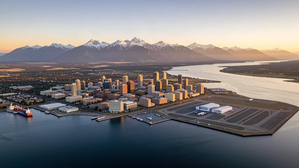
Request a Anchorage Drone Operator
Anchorage Aerial Imaging Options
Anchorage is the largest city in Alaska (population 291,000) and the economic hub of the Anchorage metro area (398,328, over half the state). The $2+ billion Port of Alaska Modernization Program is the dominant construction project, alongside JBER military facility expansion, the $300+ million Seward-Glenn Highway interchange, and residential growth in South Anchorage and the Mat-Su Valley. The city has the most complex airspace in Alaska — PANC Class C, PAMR Class D, and JBER restricted military airspace all overlap within the compact urban bowl, making local airspace expertise essential for compliant drone aerial imaging.
Anchorage Construction & Development: An Aerial Perspective
Anchorage is the largest city in Alaska with a population of 291,000 and the economic hub of the Anchorage metro area (398,328). The city has a significant construction market driven by federal infrastructure investment, resource development, military expansion, and housing demand. The flagship project is the Port of Alaska Modernization Program (PAMP) — a $2+ billion dock replacement effort to rebuild aging cargo terminals before they fail. Phase 2A delivered a new port administration building in 2024 and the North Extension Stabilization 1 Project in 2025. Phase 2B involves building two new cargo terminals, with Terminal 1 construction beginning in 2025 as a design-build contract. The port secured a $50 million federal Maritime Administration grant in November 2024, adding to over $115 million in federal port infrastructure grants awarded to Alaska projects. JBER is undergoing facility modernization including new F-22 squadron operations facilities, barracks, and fuel storage infrastructure. The Anchorage School District has ongoing bond-funded facility improvements across multiple schools. Residential construction is concentrated in South Anchorage (Olympic Mountain area) and the Mat-Su Valley (Palmer, Wasilla), where population growth is driving new subdivisions. The Alaska Department of Transportation is executing the Seward Highway to Glenn Highway connection (Brigham Landing interchange), a $300+ million highway reconstruction project. Oil and gas industry support facilities in Anchorage include new pipeline maintenance yards and North Slope logistics staging areas. The University of Alaska Anchorage is investing in engineering and health sciences facility upgrades.
Active Developers in the Area:
- Municipality of Anchorage / Port of Alaska (Don Young Port of Alaska Modernization Program — $2+ billion dock replacement and cargo terminal reconstruction, funded by federal Maritime Administration grants and state matching funds)
- Joint Base Elmendorf-Richardson (US Air Force / US Army military construction — F-22 squadron facilities, barracks modernization, fuel infrastructure, and airfield improvements under MILCON appropriations)
- Alaska Department of Transportation and Public Facilities (Seward Highway to Glenn Highway connection — $300+ million interchange and highway reconstruction project through the Anchorage bowl)
- Turnagain Construction (Anchorage-based heavy civil contractor with port, highway, and military facility projects across Southcentral Alaska)
- Davis Constructors and Engineers (Anchorage-headquartered general contractor with commercial, institutional, and industrial projects including university and healthcare facilities)
- Northstar Gas Pipeline Services (oil and gas pipeline construction and maintenance — staging yards and logistics facilities in Anchorage serving North Slope operations)

What Drone Services Cost in Alaska
These are typical Anchorage-area project ranges, drawn from market data across Anchorage Metropolitan Statistical Area (Anchorage Municipality plus Matanuska-Susitna Borough — combined population 398,328 per 2020 Census, accounting for over half of all Alaska residents). Your final price depends on site size, complexity, and deliverables.
| Service Type | Low End | High End |
|---|---|---|
| Topographic Data Collection | $1,225 | $4,650 |
| Drone Inspection | $425 | $2,100 |
| LiDAR Scanning | $2,300 | $7,850 |
| Environmental Monitoring | $625 | $2,900 |
| Aerial Imagery | $350 | $1,350 |
| Construction Monitoring | $425 | $1,850 |
| Real Estate Photography | $250 | $650 |
| Roof Inspection | $300 | $950 |
Free cost calculator, ROI calculator, and 14-page buyer's guide. No signup required.
Are you a drone operator serving Anchorage? List your business on AeriusView and get pre-qualified leads in your service area.
List Your Business →Anchorage Airspace, FAA Rules & Local Drone Laws
FAA Part 107 Requirements
All commercial drone operations in Alaska require an active FAA Part 107 Remote Pilot Certificate — every operator matched to Anchorage projects is verified.
State Drone Laws
Anchorage is governed by Alaska state drone law (AS 02.35 Alaska Aeronautics Act, AS 11.61.320 privacy statutes) and FAA Part 107 regulations. Statewide, Alaska drone law (AS 44.09.020; AS 11.61.320; SB 21 (2014); FAA Part 107; 43 CFR 9260 (BLM UAS policy)) sets the baseline for commercial operations — Part 107 rules apply on every Anchorage job. Full Alaska drone law →
Local Ordinances
Anchorage is governed by Alaska state drone law (AS 02.35 Alaska Aeronautics Act, AS 11.61.320 privacy statutes) and FAA Part 107 regulations. The Municipality of Anchorage requires a commercial use permit for drone takeoff and landing in city parks, issued through Anchorage Parks and Recreation (907-343-4355). Chugach State Park requires an Alaska DNR commercial use permit for all drone operations. The Port of Alaska and Alaska Railroad facilities have federal maritime and transportation security restrictions on aerial photography. Commercial drone filming for movies, TV, or advertising in Anchorage may require a film permit from the Anchorage Film Office. JBER military airspace coordination is mandatory for any operations near the base perimeter. LAANC authorization is required for flights within PANC Class C or PAMR Class D airspace boundaries. Alaska State Parks and BLM-managed lands require permits for commercial drone operations. The US Fish and Wildlife Service prohibits drone takeoff and landing in national wildlife refuges without a special use permit — relevant for operations near the Alaska Maritime National Wildlife Refuge. FAA Part 107 Remote Pilot Certification is required for all commercial operations. Subarctic operations require specialized battery management — LiPo batteries lose 50-70 percent capacity at 0 degrees Fahrenheit, and cold-weather pre-heating is essential from November through March.
Restricted Airspace
- Ted Stevens Anchorage International Airport (PANC) has Class C airspace with a 5 NM radius surface area and outer shelf extending to 10 NM. The Class C covers downtown Anchorage, the Seward Highway corridor, and much of west Anchorage including the Port of Alaska. Commercial drone operations within the PANC Class C lateral boundaries require LAANC authorization. PANC is a major international cargo hub — FedEx, UPS, and DHL operate heavy freight flights connecting Asia and North America, creating significant jet traffic at all hours. The airport is also a Part 93 special flight rules area with unique arrival and departure procedures under the Anchorage Terminal Area airspace.
- Joint Base Elmendorf-Richardson (JBER) occupies the entire northeast quadrant of the Anchorage bowl. The base operates F-22 Raptor fighters, C-17 Globemaster III cargo aircraft, and AH-64 Apache helicopters. JBER has restricted airspace (R-2201, R-2202, R-2203) that is active at various times, and the base perimeter has security restrictions on aerial photography. Drone operations near JBER are strictly prohibited without explicit coordination with JBER Public Affairs (907-552-8888). The F-22s conduct afterburner takeoffs and low-level training that create sudden, high-speed aircraft traffic at low altitudes — a severe hazard for drone operators.
- Merrill Field (PAMR) has Class D airspace with a 4 NM radius surface area, located approximately 2 NM east of downtown Anchorage. Merrill Field is the busiest general aviation airport in Alaska with over 400 based aircraft and constant flight training, scenic flight, and air taxi operations. The Class D area covers the east Anchorage residential neighborhoods and the University of Alaska Anchorage campus. Commercial drone operations within the PAMR Class D require tower authorization. Floatplane traffic from Lake Hood (adjacent to PANC) creates additional low-altitude aircraft traffic across the Anchorage bowl.
- The Port of Alaska (Don Young Port of Alaska) on Cook Inlet is undergoing a $2+ billion modernization program and has maritime security zone restrictions. The port receives cargo ships, fuel tankers, and cruise vessel support traffic. Drone operations near the port should maintain awareness of vessel traffic and crane operations. Cook Inlet itself has tidal changes of up to 30 feet and strong currents — any drone operations over water carry elevated risk. The Alaska Railroad Corporation operates fuel trains and cargo along the coastal rail corridor between the port and inland Alaska.
- Chugach State Park, which begins at the eastern edge of the Anchorage bowl and encompasses the Chugach Mountains, requires an Alaska DNR State Parks permit for commercial drone takeoff and landing. The park boundary is within 5 miles of downtown Anchorage, and the steep mountain terrain creates dangerous downdraft conditions. The Alaska Native Medical Center and Providence Alaska Medical Center have active medevac helicopter operations — drone operators should avoid flight near hospitals and helipads. The Alaska Railroad bridges over Ship Creek and Chester Creek have infrastructure security considerations.
Airports in the area: ANC — Ted Stevens Anchorage International Airport (Class C airspace, approximately 3 NM southwest of downtown — major cargo and passenger hub connecting Asia, North America, and Europe; LAANC available), EDF — Elmendorf Air Force Base / Joint Base Elmendorf-Richardson (Class D/restricted military airspace, approximately 5 NM north — F-22 Raptor and C-17 Globemaster III operations; restricted airspace, never fly without explicit military authorization), MRH — Merrill Field (Class D airspace, approximately 2 NM east of downtown — busiest GA airport in Alaska with 400+ based aircraft; LAANC available), PAED — Birchwood Airport (uncontrolled GA airspace, approximately 20 NM north in Chugiak — no tower, CTAF operations; check for nearby military training routes), HQN — Whittier Airport (uncontrolled airspace, approximately 60 NM southeast — small GA facility serving Prince William Sound; check weather limitations)
Why Anchorage Contractors Trust Aerius View
FAA-Certified
Every operator holds an active Part 107 Remote Pilot Certificate.
Local to Anchorage
Pilots who fly Anchorage regularly — they know the Anchorage Municipality staging spots, permit offices, and airspace quirks.
No Cost to Quote
Submit your project at no charge. Pay the operator directly if you proceed.
Fast Turnaround
Expect the first call within 2 business days from an operator covering Anchorage Municipality.
AeriusView is expanding in Anchorage, AK
Pilot coverage for Anchorage is filling in — surrounding Anchorage Metropolitan Statistical Area (Anchorage Municipality plus Matanuska-Susitna Borough — combined population 398,328 per 2020 Census, accounting for over half of all Alaska residents) cities are already served. Requests from Anchorage are routed to the nearest verified operator.
Request a QuoteWhat Aerial Data Products Do You Receive in Anchorage?
an Anchorage project wraps with professional-grade deliverables built for the software stacks Anchorage Municipality crews already run. Projects like those delivered for Municipality of Anchorage / Port of Alaska across Anchorage Municipality need data that drops straight into their workflow.
- DEM/DSM terrain models for cut/fill and grade analysis
- Contour lines (DXF/DWG, CAD-ready) for Civil 3D and Revit
- Progress reports with side-by-side comparisons for construction monitoring
- Orthomosaic maps (GeoTIFF) for site overview and documentation
- Point clouds (LAS/LAZ) for 3D modeling and volumetric analysis
- Coordinate systems matched to your project datum — the Alaska State Plane zone, UTM, or a local datum your surveyor specifies
Insurance & Liability Protection
Pilot Insurance Required
Every operator matched to an Anchorage project carries active liability insurance — minimum $1,000,000 general liability, verified from the certificate before the pilot joins the network. Anchorage is governed by Alaska state drone law (AS 02.35 Alaska Aeronautics Act, AS 11.61.320 privacy statutes) and FAA Part 107 regulations. The Municipality of Anchorage requires a commercial use permit for drone takeoff and landing in city parks, issued through Anchorage Parks and Recreation (907-343-4355). Chugach State Park requires an Alaska DNR commercial use permit for all drone operations. The Port of Alaska and Alaska Railroad facilities have federal maritime and transportation security restrictions on aerial photography. Commercial drone filming for movies, TV, or advertising in Anchorage may require a film permit from the Anchorage Film Office. JBER military airspace coordination is mandatory for any operations near the base perimeter. LAANC authorization is required for flights within PANC Class C or PAMR Class D airspace boundaries. Alaska State Parks and BLM-managed lands require permits for commercial drone operations. The US Fish and Wildlife Service prohibits drone takeoff and landing in national wildlife refuges without a special use permit — relevant for operations near the Alaska Maritime National Wildlife Refuge. FAA Part 107 Remote Pilot Certification is required for all commercial operations. Subarctic operations require specialized battery management — LiPo batteries lose 50-70 percent capacity at 0 degrees Fahrenheit, and cold-weather pre-heating is essential from November through March.
FAA Part 107 Verified
Each pilot's Remote Pilot Certificate is checked against the FAA Airmen Inquiry before they can serve Anchorage Municipality bookings. Expired certificates are flagged automatically.
Equipment Documentation
Pilots register their airframes and sensors (RGB, LiDAR, thermal, multispectral) so Anchorage requests route to crews with the right payload for the job.
Site Safety Coordination
Pilots coordinate with your site superintendent for safe operations on active Anchorage construction sites, including flight plans that avoid worker areas and equipment zones. Anchorage is governed by Alaska state drone law (AS 02.35 Alaska Aeronautics Act, AS 11.61.320 privacy statutes) and FAA Part 107 regulations. The Municipality of Anchorage requires a commercial use permit for drone takeoff and landing in city parks, issued through Anchorage Parks and Recreation (907-343-4355). Chugach State Park requires an Alaska DNR commercial use permit for all drone operations. The Port of Alaska and Alaska Railroad facilities have federal maritime and transportation security restrictions on aerial photography. Commercial drone filming for movies, TV, or advertising in Anchorage may require a film permit from the Anchorage Film Office. JBER military airspace coordination is mandatory for any operations near the base perimeter. LAANC authorization is required for flights within PANC Class C or PAMR Class D airspace boundaries. Alaska State Parks and BLM-managed lands require permits for commercial drone operations. The US Fish and Wildlife Service prohibits drone takeoff and landing in national wildlife refuges without a special use permit — relevant for operations near the Alaska Maritime National Wildlife Refuge. FAA Part 107 Remote Pilot Certification is required for all commercial operations. Subarctic operations require specialized battery management — LiPo batteries lose 50-70 percent capacity at 0 degrees Fahrenheit, and cold-weather pre-heating is essential from November through March.
Anchorage, AK Drone & Aerial Imaging Questions
Do I need LAANC authorization to fly a drone in Anchorage?
Most of central and west Anchorage falls within the Ted Stevens Anchorage International Airport (PANC) Class C airspace, which has a 5 NM radius surface area and outer shelves to 10 NM. The Class C covers downtown, the Port of Alaska, and the Seward Highway corridor. Commercial drone operations within the PANC Class C require LAANC authorization. Additionally, Merrill Field (PAMR) Class D airspace covers east Anchorage within a 4 NM radius, and Joint Base Elmendorf-Richardson (JBER) has restricted military airspace over the northeast quadrant. Check all three airspace areas before any flight.
What is the cost of aerial imaging for a construction site in Anchorage?
Topographic drone data collection in Anchorage typically ranges from $1,200 to $4,500 depending on acreage, terrain, and proximity to PANC Class C or JBER restricted airspace. Construction monitoring visits cost $400 to $1,800 per session. LiDAR scanning runs $2,200 to $7,500. The Port of Alaska Modernization Program ($2+ billion), Seward Highway reconstruction, and JBER military construction create strong demand for aerial mapping and progress documentation.
Can I fly a drone near Joint Base Elmendorf-Richardson?
JBER occupies the entire northeast quadrant of the Anchorage bowl and operates F-22 Raptors, C-17 Globemasters, and Apache helicopters under restricted airspace (R-2201 through R-2203). Drone operations near JBER are strictly prohibited without explicit coordination with JBER Public Affairs at 907-552-8888. The F-22s conduct afterburner takeoffs creating sudden, high-speed, low-altitude traffic — a severe hazard for drone operators. The base perimeter also has security restrictions on aerial photography.
Can I fly a drone in Chugach State Park near Anchorage?
Chugach State Park begins at the eastern edge of the Anchorage bowl and requires an Alaska DNR State Parks commercial use permit for all drone takeoff and landing operations. The park boundary is within 5 miles of downtown, and the steep Chugach Mountain terrain creates dangerous downdraft conditions. Contact Alaska DNR State Parks at 907-345-5014 for permit applications. FAA Part 107 prohibits flying directly over non-participants, and the popular trail systems mean hikers are frequently present.
What are the cold-weather considerations for drone operations in Anchorage?
Anchorage has a subarctic climate with winter temperatures regularly dropping below -10 degrees Fahrenheit. LiPo drone batteries lose 50-70 percent of capacity at 0 degrees Fahrenheit, and cells can fail mid-flight in extreme cold. Battery warmers and pre-heating are essential from November through March. The Midnight Sun season (May-July) provides nearly 24 hours of daylight, while Aurora season (September-April) offers spectacular night photography opportunities. Cook Inlet weather can change rapidly at any time of year. Always check NWS Anchorage forecasts before flying.
What aerial imaging opportunities exist at the Port of Alaska Modernization Program?
The Port of Alaska Modernization Program is a $2+ billion dock replacement effort with Phase 2B construction of two new cargo terminals beginning in 2025. The project requires extensive drone aerial imaging for site grading, dock construction inspection, crane installation documentation, and structural monitoring. However, the port has maritime security zone restrictions on aerial photography. Commercial operators must coordinate with the Municipality of Anchorage Port Department and check for active cargo vessel traffic. The port secured $50 million in federal Maritime Administration grants, ensuring sustained construction activity through 2030.
Aerial Imaging Terms for Anchorage Projects
The vocabulary behind Anchorage aerial data — useful before you request quotes. Most Anchorage projects in our cost table start around $250.
Point Cloud
A 3D dataset of points representing the captured surface.
Real-Time Kinematic
RTK GPS correction for centimeter-level positional accuracy.
LiDAR
Laser scanning that captures terrain through vegetation.
Digital Elevation Model
A 3D representation of terrain elevation across the site.
Ground Control Point
Known reference markers used to anchor and validate mapping accuracy.
Aerial Mapping
Data collection from above to map and measure a site.
Volumetrics
Cut/fill and stockpile volume calculations derived from terrain models.
Thermal Imaging
Infrared capture that reveals heat signatures for inspections.
Nearby Cities
Are You a Drone Operator in Anchorage?
Serve Anchorage and the wider Anchorage Metropolitan Statistical Area (Anchorage Municipality plus Matanuska-Susitna Borough — combined population 398,328 per 2020 Census, accounting for over half of all Alaska residents) : leads routed by service area, no fees to join, first lead free.
Ready to Start Your Project in Anchorage, AK?
One form, then a Anchorage Metropolitan Statistical Area (Anchorage Municipality plus Matanuska-Susitna Borough — combined population 398,328 per 2020 Census, accounting for over half of all Alaska residents)-based operator follows up with a quote. No cost, no commitment. Projects in Anchorage Municipality start around $250.
Request a Free QuoteAeriusView connects clients with FAA-certified drone operators. Services are not licensed land surveying. Deliverables are not authoritative for boundary determination, design, or legal purposes.