Drone Survey Services in Boerne, TX
From luxury Hill Country ranch-to-residential conversions and master-planned communities along Highway 46 to Boerne ISD school construction and I-10 commercial corridor growth, Boerne is the seat of Kendall County, one of the fastest-growing counties in the US.
Serving Kendall County & the San Antonio-New Braunfels area
Request a Free Quote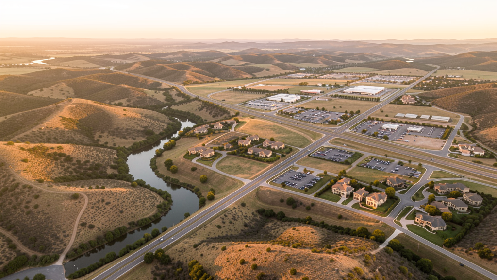
Get Matched With a Local Surveyor
Drone Survey Services Available in Boerne, TX
Boerne sits in the Texas Hill Country along I-10 in Kendall County, about 25 miles NW of San Antonio. Kendall County is one of the fastest-growing counties in the US by percentage growth rate, with 40%+ population growth since 2010. Boerne attracts luxury residential development, retirement communities, and boutique commercial development. The city is near three military installations (Lackland, Randolph, Fort Sam Houston), requiring airspace coordination for some flights.
Drone Surveys for Boerne's Construction Market
Boerne is the county seat of Kendall County, one of the fastest-growing counties in the US by percentage growth rate. The city sits in the Texas Hill Country along I-10, attracting luxury residential development, retirement communities, and boutique commercial development. Major projects include the Boerne ISD school construction program, the Cibolo Center for Conservation, and multiple master-planned communities along Highway 46. The Kendall County population has grown over 40% since 2010, with Boerne as the primary growth center. Ranch-to-residential conversion is driving demand for large-acreage topographic surveys.
Active Developers in the Area:
Typical Project Costs in Texas
Cost ranges are based on market data for San Antonio-New Braunfels. Actual pricing depends on site size, complexity, and deliverables.
| Service Type | Low End | High End |
|---|---|---|
| Topographic Survey | $1,800 | $4,500 |
| Drone Inspection | $250 | $850 |
| LiDAR Scanning | $2,800 | $8,000 |
| Environmental Monitoring | $800 | $3,000 |
| Aerial Imagery | $175 | $500 |
| Construction Monitoring | $1,100 | $3,200 |
| Real Estate Photography | $175 | $500 |
| Roof Inspection | $200 | $750 |
Local Airspace & Regulations in Boerne, TX
FAA Part 107 Requirements
All commercial drone operations in Texas require the pilot to hold an active FAA Part 107 Remote Pilot Certificate. Our network surveyors are verified Part 107 holders.
State Drone Laws
Texas Government Code Chapter 423 restricts drone use over critical infrastructure facilities, including oil and gas pipelines, refineries, power plants, and water treatment facilities. HB 1484 (2023) added protections for agricultural operations and expanded penalties for drone surveillance of private property. Commercial operators must hold a valid FAA Part 107 Remote Pilot Certificate. Texas does not require a separate state drone license, but operators flying near critical infrastructure must obtain authorization from the facility owner. The Texas Department of Public Safety maintains additional guidelines for drone operations near state facilities.
Local Ordinances
Boerne follows Kendall County regulations and FAA Part 107 rules. No city-specific drone permit is required for operations from private property. The city is near three military installations (Lackland, Randolph, Fort Sam Houston), and flights near military airspace require coordination. Boerne Stage Airfield (COT) is a small Class E airport 5 miles north. City parks along Cibolo Creek prohibit drone takeoff/landing without a permit. The Hill Country terrain and narrow canyons require experienced drone pilots for safe operations.
Restricted Airspace
- Class C airspace around San Antonio International (SAT) extends 20 nautical miles. The southern edge of Kendall County may require LAANC authorization at higher altitudes.
- Military airspace around Lackland AFB (SKF) and Randolph AFB (RND) — drone flights within 5 miles require coordination with base operations.
- Boerne Stage Airfield (COT) is Class E — no LAANC required but pilots must notify the airport when operating within 5 miles.
- Kendall County has no county-wide drone ordinance. Boerne city parks along Cibolo Creek prohibit takeoff/landing without a special use permit.
Airports in the area: undefined (undefined), undefined (undefined), undefined (undefined), undefined (undefined)
Why Hire Through Aerius View in Boerne, TX?
FAA-Certified
Every surveyor holds an active Part 107 Remote Pilot Certificate.
Local to Boerne
Surveyors who know the Texas airspace and local permitting.
No Cost to Quote
Submit your project at no charge. Pay the surveyor directly if you proceed.
Fast Turnaround
A local surveyor contacts you within 2 business days.
How Our Boerne Matching Process Works
We're actively building our network of FAA-certified drone operators in Boerne, TX. Here's exactly what happens when you submit a project request.
Submit Your Project
Tell us your site location, acreage, and what you need (topographic survey, LiDAR, inspection, etc.). Takes 60 seconds. No cost, no obligation.
We Match & Vet
We identify Part 107-certified operators in Texas with the right equipment for your project. Every pilot is verified for active certification, insurance, and relevant experience in Texas airspace.
You Get Quotes
Matched surveyors contact you within 2 business days with quotes. You compare pricing, timelines, and deliverables, then choose the right fit. You pay the surveyor directly, no markup.
What Deliverables Do You Get?
Every project includes professional-grade deliverables compatible with standard construction and engineering software:
- Orthomosaic maps (GeoTIFF) for site overview and documentation
- Point clouds (LAS/LAZ) for 3D modeling and volumetric analysis
- DEM/DSM terrain models for cut/fill and grade analysis
- Contour lines (DXF/DWG, CAD-ready) for Civil 3D and Revit
- Progress reports with side-by-side comparisons for construction monitoring
- Coordinate systems matched to your project datum (State Plane, UTM, or local)
Insurance & Liability Protection
Pilot Insurance Required
Every operator in our network must carry active liability insurance. Minimum coverage: $1,000,000 general liability. Proof of insurance is verified before any pilot joins the network.
FAA Part 107 Verified
We confirm each pilot's Remote Pilot Certificate is active and in good standing through the FAA Airmen Inquiry system. Expired certificates are flagged automatically.
Equipment Documentation
Pilots list their drone models, sensors (RGB, LiDAR, thermal, multispectral), and payload specs so we can match the right equipment to your project requirements.
Site Safety Coordination
Pilots coordinate with your site superintendent for safe operations on active construction sites, including flight plans that avoid worker areas and equipment zones.
Boerne, TX Drone Survey FAQs
Do I need a permit for a drone survey in Boerne?
No city-specific permit is required for commercial drone operations from private property in Boerne. All flights must comply with FAA Part 107 rules. The city is near three military installations, and flights near military airspace require coordination. Takeoff/landing in city parks along Cibolo Creek requires a special use permit.
How much does a drone survey cost in Boerne, TX?
Topographic surveys in Kendall County typically range from $1,800 to $4,500, with premium rates for large-acreage ranch properties. Roof inspections run $200-$750. LiDAR scanning for Hill Country terrain costs $2,800-$8,000. Real estate drone photography for luxury Hill Country properties starts at $175.
Are there military airspace restrictions near Boerne?
Boerne is within 30 miles of Lackland AFB, Randolph AFB, and Fort Sam Houston. While most of Kendall County is outside their immediate restricted zones, flights to the south may require coordination with base operations. Always check NOTAMs before flying near military installations.
What is driving construction growth in Boerne?
Kendall County is one of the fastest-growing counties in the US by percentage growth rate, with 40%+ population growth since 2010. Boerne is the primary growth center, attracting luxury residential development, retirement communities, and commercial construction along I-10 and Highway 46. Ranch-to-residential conversion drives large-acreage survey demand.
How does Hill Country terrain affect drone surveys in Boerne?
The Texas Hill Country has rolling hills, narrow canyons, and tree canopy that require experienced drone pilots. Wind patterns change with terrain features, and GPS reception may be affected in canyons. Large ranch properties may require multiple flight batteries and strategic launch points. Our surveyors account for terrain complexity in flight planning.
Nearby Cities
Are You a Drone Surveyor in Boerne?
Get pre-qualified leads in your service area. No membership fees, no monthly minimums. First lead free.
Ready to Start Your Project in Boerne, TX?
Get matched with a local, FAA-certified surveyor. No cost, no obligation.
Request a Free Quote