Drone Survey Services in Boise, ID
From the $500 million Boise Centre expansion to the $400 million St. Luke medical campus modernization, Boise is experiencing its largest construction cycle in decades with downtown towers, transit infrastructure, and 2,500+ new residential units driving relentless demand for drone survey and construction monitoring services.
Serving Ada County & the Boise City area
Request a Free Quote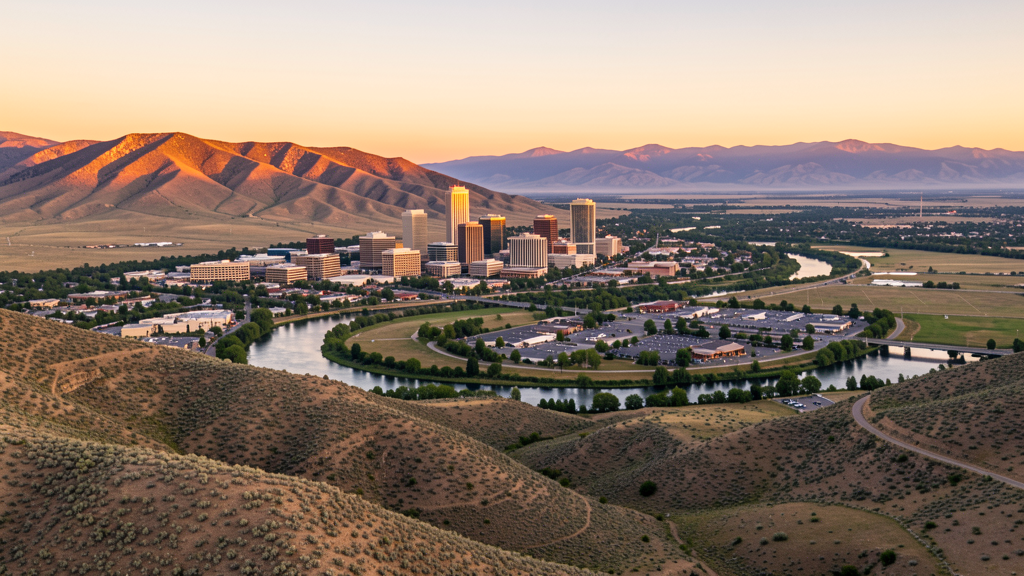
Get Matched With a Local Surveyor
Drone Survey Services Available in Boise, ID
Boise anchors the Treasure Valley as Idaho capital and largest city, serving as the commercial, government, and cultural hub for a metro exceeding 750,000 people. The city combines a booming downtown with rapid westward expansion toward Meridian and Eagle, creating dual demand centers for drone survey services. BOI Class C airspace covers the central city, while the Boise Foothills and National Forest to the north create terrain-aware flight planning challenges unique among Idaho markets.
Drone Surveys for Boise's Construction Market
Boise is experiencing a major downtown and west-end construction boom. The $500 million Boise Centre expansion, the 16-story Idaho Central Credit Union headquarters, and the Zion Bank tower represent significant vertical construction. St. Luke Boise Medical Center is undergoing a $400 million campus modernization. The Idaho Transportation Department is widening Highway 44 (State Street) and the Connector. Residential permitting exceeded 2,500 new housing units in 2023-2024, with major infill development in the West End and Lusk District. The city is also expanding its public transit infrastructure with Valley Regional Transit bus rapid transit planning.
Active Developers in the Area:

Typical Project Costs in Idaho
Cost ranges are based on market data for Boise City. Actual pricing depends on site size, complexity, and deliverables.
| Service Type | Low End | High End |
|---|---|---|
| Topographic Survey | $1,400 | $5,000 |
| Drone Inspection | $900 | $3,200 |
| LiDAR Scanning | $3,200 | $8,500 |
| Environmental Monitoring | $1,600 | $5,200 |
| Aerial Imagery | $550 | $2,200 |
| Construction Monitoring | $1,100 | $3,800 |
| Real Estate Photography | $350 | $1,400 |
| Roof Inspection | $450 | $1,600 |
Local Airspace & Regulations in Boise, ID
FAA Part 107 Requirements
All commercial drone operations in Idaho require the pilot to hold an active FAA Part 107 Remote Pilot Certificate. Our network surveyors are verified Part 107 holders.
State Drone Laws
Idaho Code § 21-801 et seq (Title 21, Chapter 8) governs unmanned aircraft systems statewide. The law prohibits drone surveillance of private property without consent (§ 21-803, $500 civil penalty per violation), bans weaponization of drones (§ 21-804, misdemeanor), and prohibits using drones to interfere with wildfire suppression (§ 21-805). The state preempts local regulation of drone flight paths and airspace (§ 21-810), though cities may regulate takeoff and landing on public property they own. Idaho does not require a separate state-level drone license. Commercial drone operators must hold a valid FAA Part 107 Remote Pilot Certificate. Idaho was one of the first states to pass comprehensive drone legislation in 2013 (HB 279), amended by SB 1133 (2021) to align definitions with the federal Part 107 framework.
Local Ordinances
Boise City Code requires a Special Use Permit for commercial drone operations taking off or landing on city-owned property, including all parks and recreation areas along the Greenbelt. The permit costs $75 with a 10-day processing period through Boise Parks and Recreation. Flights from private property (with owner permission) do not require a city permit but must comply with FAA Part 107 rules. Idaho Code section 21-810 preempts Boise from regulating drone airspace or flight paths. The city nuisance ordinance applies to low-altitude flights over private property on a complaint-driven basis.
Restricted Airspace
- Class C airspace around BOI extends 10 nautical miles, surface to 10,000 ft MSL. Central Boise falls within the 5 NM inner core requiring LAANC authorization. Commercial drone flights need LAANC approval via Aloft or DroneUp apps.
- Gowen Field (Idaho Air National Guard) adjacent to BOI. Frequent NOTAMs and TFRs during training exercises. Check NOTAMs within 5 NM before flying.
- Boise National Forest north of city limits. Seasonal fire TFRs common July through October. No permanent restriction but check current NOTAMs.
- Boise Foothills and Ridge to Rivers trail system. BLM-managed lands in the foothills require special use permits for commercial drone operations.
- Boise River Greenbelt is a city park corridor. Boise City Code prohibits drone takeoff and landing in parks without a Special Use Permit from Boise Parks and Recreation.
- Simplot Sports Complex and other large outdoor venues may have temporary flight restrictions during events. Check for stadium TFRs.
Airports in the area: undefined (undefined), undefined (undefined), undefined (undefined)
Why Hire Through Aerius View in Boise, ID?
FAA-Certified
Every surveyor holds an active Part 107 Remote Pilot Certificate.
Local to Boise
Surveyors who know the Idaho airspace and local permitting.
No Cost to Quote
Submit your project at no charge. Pay the surveyor directly if you proceed.
Fast Turnaround
A local surveyor contacts you within 2 business days.
How Our Boise Matching Process Works
We're actively building our network of FAA-certified drone operators in Boise, ID. Here's exactly what happens when you submit a project request.
Submit Your Project
Tell us your site location, acreage, and what you need (topographic survey, LiDAR, inspection, etc.). Takes 60 seconds. No cost, no obligation.
We Match & Vet
We identify Part 107-certified operators in Idaho with the right equipment for your project. Every pilot is verified for active certification, insurance, and relevant experience in Idaho airspace.
You Get Quotes
Matched surveyors contact you within 2 business days with quotes. You compare pricing, timelines, and deliverables, then choose the right fit. You pay the surveyor directly, no markup.
What Deliverables Do You Get?
Every project includes professional-grade deliverables compatible with standard construction and engineering software:
- Orthomosaic maps (GeoTIFF) for site overview and documentation
- Point clouds (LAS/LAZ) for 3D modeling and volumetric analysis
- DEM/DSM terrain models for cut/fill and grade analysis
- Contour lines (DXF/DWG, CAD-ready) for Civil 3D and Revit
- Progress reports with side-by-side comparisons for construction monitoring
- Coordinate systems matched to your project datum (State Plane, UTM, or local)
Insurance & Liability Protection
Pilot Insurance Required
Every operator in our network must carry active liability insurance. Minimum coverage: $1,000,000 general liability. Proof of insurance is verified before any pilot joins the network.
FAA Part 107 Verified
We confirm each pilot's Remote Pilot Certificate is active and in good standing through the FAA Airmen Inquiry system. Expired certificates are flagged automatically.
Equipment Documentation
Pilots list their drone models, sensors (RGB, LiDAR, thermal, multispectral), and payload specs so we can match the right equipment to your project requirements.
Site Safety Coordination
Pilots coordinate with your site superintendent for safe operations on active construction sites, including flight plans that avoid worker areas and equipment zones.
Boise, ID Drone Survey FAQs
Do I need LAANC authorization to fly a drone in Boise?
Yes. Central Boise falls within the BOI Class C airspace inner core (5 NM). All commercial drone flights require FAA LAANC authorization. Use the Aloft or DroneUp LAANC apps to request instant approval for altitudes up to 400 ft AGL.
Can I fly a drone over Boise parks and the Greenbelt?
Not without a permit. Boise City Code prohibits drone takeoff and landing from city parks and Greenbelt corridors without a Special Use Permit from Boise Parks and Recreation ($75 fee, 10-day processing).
What major construction projects are driving drone survey demand in Boise?
The $500 million Boise Centre expansion, St. Luke Boise $400 million campus modernization, and downtown tower construction (Idaho Central Credit Union HQ, Zion Bank tower) are the largest projects. The Idaho Transportation Department Highway 44 widening and Connector expansion also require ongoing aerial survey support.
Are there military airspace restrictions near Boise?
Yes. Gowen Field (Idaho Air National Guard) is adjacent to BOI. Frequent NOTAMs and TFRs are issued during training exercises. Check NOTAMs within 5 NM of BOI before every commercial drone flight.
How much does a drone LiDAR survey cost in Boise?
LiDAR survey pricing in Boise ranges from $3,200 to $8,500 depending on acreage, point density requirements, and deliverable complexity. Turnaround is generally 5-10 business days. Standard topographic surveys are less expensive at $1,400 to $5,000.
Nearby Cities
Are You a Drone Surveyor in Boise?
Get pre-qualified leads in your service area. No membership fees, no monthly minimums. First lead free.
Ready to Start Your Project in Boise, ID?
Get matched with a local, FAA-certified surveyor. No cost, no obligation.
Request a Free Quote