Drone Survey Services in Conroe, TX
Conroe is the fastest-growing city in Texas, where I-45 corridor master-planned communities, Lake Conroe waterfront development, and proximity to the ExxonMobil Spring campus are driving explosive demand for topographic surveys and construction monitoring across Montgomery County.
Serving Montgomery County & the Houston-The Woodlands-Sugar Land area
Request a Free Quote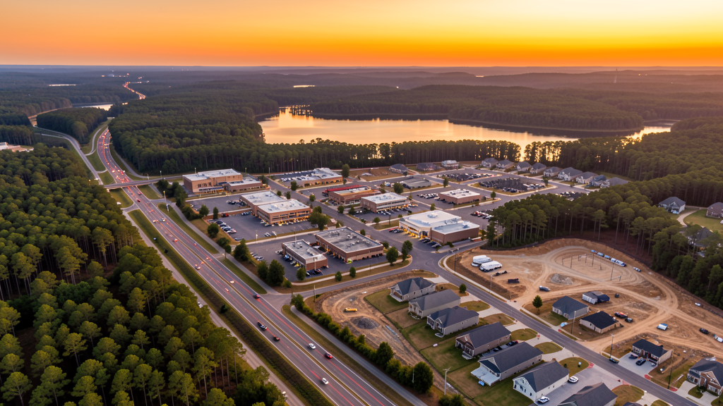
Get Matched With a Local Surveyor
Drone Survey Services Available in Conroe, TX
Conroe anchors the north end of the Houston-The Woodlands-Sugar Land metro as the county seat of Montgomery County, one of the fastest-growing counties in the United States. The population surged past 100,000 as Houston metro expansion pushed north along I-45. Master-planned communities including Artavia, Grandshire, and Harper's Preserve, combined with Lake Conroe resort development and the TX-249 toll road extension, generate sustained demand for topographic surveys, LiDAR mapping, and construction monitoring.
Drone Surveys for Conroe's Construction Market
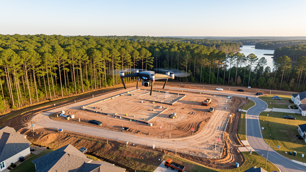
Conroe was the fastest-growing city in Texas from 2020-2024, with the population surging past 100,000 as Houston metro expansion pushed north along the I-45 corridor. Montgomery County is one of the fastest-growing counties in the United States, driven by master-planned communities including Artavia, Grandshire, Harper's Preserve, and Margaritaville Lake Resort. The ExxonMobil campus in nearby Spring (350 acres, 10,000+ employees) anchors the southern end of the county and drives ancillary commercial and residential development. The Conroe Industrial Park along FM 1314 continues to see light manufacturing and warehouse construction. Lake Conroe waterfront development, including high-end residential and resort properties, generates demand for topographic surveys and construction monitoring. The TX-249 toll road extension connecting Conroe to the northwest Houston metro opened new development corridors.
Active Developers in the Area:
Typical Project Costs in Texas
Cost ranges are based on market data for Houston-The Woodlands-Sugar Land. Actual pricing depends on site size, complexity, and deliverables.
| Service Type | Low End | High End |
|---|---|---|
| Topographic Survey | $1,500 | $4,500 |
| Drone Inspection | $225 | $800 |
| LiDAR Scanning | $2,500 | $8,500 |
| Environmental Monitoring | $800 | $3,500 |
| Aerial Imagery | $175 | $500 |
| Construction Monitoring | $900 | $3,000 |
| Real Estate Photography | $150 | $450 |
| Roof Inspection | $200 | $750 |
Local Airspace & Regulations in Conroe, TX
FAA Part 107 Requirements
All commercial drone operations in Texas require the pilot to hold an active FAA Part 107 Remote Pilot Certificate. Our network surveyors are verified Part 107 holders.
State Drone Laws
Texas Government Code Chapter 423 restricts drone use over critical infrastructure facilities, including oil and gas pipelines, refineries, power plants, and water treatment facilities. HB 1484 (2023) added protections for agricultural operations and expanded penalties for drone surveillance of private property. Commercial operators must hold a valid FAA Part 107 Remote Pilot Certificate. Texas does not require a separate state drone license, but operators flying near critical infrastructure must obtain authorization from the facility owner. The Texas Department of Public Safety maintains additional guidelines for drone operations near state facilities.
Local Ordinances
Conroe does not issue a separate city-level drone permit for commercial operators. FAA Part 107 certification is the primary requirement. Drone takeoff and landing on city-owned property, including Carl Barton Jr. Community Park and Candy Cane Park, requires a special use permit from Conroe Parks and Recreation. Commercial filming on city property requires a permit through the Conroe Film Commission. The southern portion of Conroe falls within the IAH Class B outer shelf, making LAANC authorization mandatory for most commercial flights south of FM 2854. Flights from private property (with owner permission) do not require a city permit but must comply with all FAA Part 107 rules and Texas Government Code Chapter 423 critical infrastructure restrictions.
Restricted Airspace
- Class B airspace around George Bush Intercontinental (IAH) — the northern shelf of IAH Class B extends into southern Montgomery County, approximately 15-20 miles from Conroe. Most of Conroe proper falls outside the surface area but within the outer shelves. LAANC authorization is required for commercial drone flights in the southern half of Conroe and along the I-45 corridor toward the airport.
- Class D airspace around David Wayne Hooks Memorial Airport (DWH) — located 20 miles southwest in Tomball. Drone flights within 4 nautical miles of DWH require LAANC authorization. This affects survey work in the southwest corner of Montgomery County.
- Lone Star Executive Airport (CXO) — uncontrolled Class E airspace, no LAANC required for typical commercial drone operations. However, CXO has active general aviation traffic including corporate jets and helicopter operations. Pilots should monitor CTAF 122.8 and maintain visual separation. High traffic volume during oil and gas industry commuting hours (7-9 AM, 4-6 PM).
- Lake Conroe — popular recreational area with heavy boat and personal watercraft traffic on weekends. While not formal restricted airspace, low-altitude drone flights over the lake during peak recreation times (weekends, holidays) risk interfering with water sports. FAA Part 107 prohibits flights over moving vehicles not under the operator's control. Recommend weekday morning flights for any lake-adjacent survey work.
- Sam Houston National Forest — located immediately north of Conroe. Drone flights over national forest land are regulated by the US Forest Service. Commercial drone operations require a special use permit from the Sam Houston Ranger District. Flights for survey or mapping purposes on private inholdings within the forest boundary still require coordination with the ranger district office.
- ExxonMobil Houston campus (Spring, 10 miles south) — critical infrastructure under TX Government Code Chapter 423. Drone flights over or near the ExxonMobil campus without authorization violate state law. The campus has active security and airspace monitoring.
- Hurricane and tropical weather: Conroe sits inland enough to avoid storm surge but is vulnerable to high winds, tornadoes, and flash flooding from Gulf weather systems. Drone operations during tropical storm warnings are restricted. Post-storm damage assessment flights require coordination with Montgomery County Office of Emergency Management. Summer thunderstorms are frequent — morning flights are strongly preferred May through September.
Airports in the area: undefined (undefined), undefined (undefined), undefined (undefined), undefined (undefined)
Why Hire Through Aerius View in Conroe, TX?
FAA-Certified
Every surveyor holds an active Part 107 Remote Pilot Certificate.
Local to Conroe
Surveyors who know the Texas airspace and local permitting.
No Cost to Quote
Submit your project at no charge. Pay the surveyor directly if you proceed.
Fast Turnaround
A local surveyor contacts you within 2 business days.
How Our Conroe Matching Process Works
We're actively building our network of FAA-certified drone operators in Conroe, TX. Here's exactly what happens when you submit a project request.
Submit Your Project
Tell us your site location, acreage, and what you need (topographic survey, LiDAR, inspection, etc.). Takes 60 seconds. No cost, no obligation.
We Match & Vet
We identify Part 107-certified operators in Texas with the right equipment for your project. Every pilot is verified for active certification, insurance, and relevant experience in Texas airspace.
You Get Quotes
Matched surveyors contact you within 2 business days with quotes. You compare pricing, timelines, and deliverables, then choose the right fit. You pay the surveyor directly, no markup.
What Deliverables Do You Get?
Every project includes professional-grade deliverables compatible with standard construction and engineering software:
- Orthomosaic maps (GeoTIFF) for site overview and documentation
- Point clouds (LAS/LAZ) for 3D modeling and volumetric analysis
- DEM/DSM terrain models for cut/fill and grade analysis
- Contour lines (DXF/DWG, CAD-ready) for Civil 3D and Revit
- Progress reports with side-by-side comparisons for construction monitoring
- Coordinate systems matched to your project datum (State Plane, UTM, or local)
Insurance & Liability Protection
Pilot Insurance Required
Every operator in our network must carry active liability insurance. Minimum coverage: $1,000,000 general liability. Proof of insurance is verified before any pilot joins the network.
FAA Part 107 Verified
We confirm each pilot's Remote Pilot Certificate is active and in good standing through the FAA Airmen Inquiry system. Expired certificates are flagged automatically.
Equipment Documentation
Pilots list their drone models, sensors (RGB, LiDAR, thermal, multispectral), and payload specs so we can match the right equipment to your project requirements.
Site Safety Coordination
Pilots coordinate with your site superintendent for safe operations on active construction sites, including flight plans that avoid worker areas and equipment zones.
Conroe, TX Drone Survey FAQs
Do I need a permit for a drone survey in Conroe?
Conroe does not issue a separate city-level drone permit for commercial operators. You need a special use permit only if you plan to take off or land on city-owned park property. FAA Part 107 certification is mandatory. The southern half of Conroe falls within the IAH Class B outer shelf, so LAANC authorization is required for most commercial flights south of FM 2854. Flights from private property with owner permission do not require a city permit.
How much does a drone survey cost in Conroe and Montgomery County?
Costs in the Conroe area are slightly below Houston metro averages due to lower overhead. Topographic surveys typically range from $1,500 to $4,500 depending on acreage. LiDAR scanning runs $2,500 to $8,500 for wooded or lakefront sites. Roof inspections cost $200 to $750 per building. Construction monitoring is typically $900 to $3,000 per month for recurring flights on master-planned community sites.
Can I fly a drone near Lone Star Executive Airport in Conroe?
Lone Star Executive Airport (CXO) is uncontrolled Class E airspace, so LAANC authorization is not required for typical commercial drone operations. However, CXO has heavy general aviation traffic including corporate jets and helicopter operations serving the oil and gas industry. You should monitor CTAF frequency 122.8, maintain visual separation from manned aircraft, and avoid flight hours during industry commuting times (7-9 AM and 4-6 PM) when traffic peaks.
Does Conroe's location near IAH airport affect drone operations?
Yes. The northern shelf of George Bush Intercontinental's Class B airspace extends into southern Montgomery County, approximately 15-20 miles from downtown Conroe. Most of Conroe proper falls outside the surface area but within the outer shelves. LAANC authorization is required for commercial flights in the southern half of Conroe and along the I-45 corridor. Always check the FAA UAS Facility Maps and B4UFLY before flying in the southern portions of the city.
Are there restrictions on flying drones over Sam Houston National Forest?
Yes. Sam Houston National Forest is located immediately north of Conroe and covers over 160,000 acres. The US Forest Service regulates drone flights over national forest land. Commercial drone operations require a special use permit from the Sam Houston Ranger District office. Even flights over private inholdings within the forest boundary require coordination. Violations can result in federal citations and confiscation of equipment.
What makes Conroe unique for drone survey work?
Conroe is the fastest-growing city in Texas, driven by master-planned communities along the I-45 corridor and Lake Conroe waterfront development. The mix of dense wooded MPC sites, lakefront residential, industrial park expansion, and proximity to the ExxonMobil campus creates diverse survey demand. The heavily forested terrain in Montgomery County makes LiDAR particularly valuable, as photogrammetry alone cannot penetrate the pine and hardwood canopy common throughout the area.
Nearby Cities
Are You a Drone Surveyor in Conroe?
Get pre-qualified leads in your service area. No membership fees, no monthly minimums. First lead free.
Ready to Start Your Project in Conroe, TX?
Get matched with a local, FAA-certified surveyor. No cost, no obligation.
Request a Free Quote