Drone Survey Services in Nampa, ID
Nampa I-84 industrial corridor, the College of Western Idaho campus expansion, and the downtown First Street South revitalization are driving Canyon County fastest commercial growth rate, creating sustained demand for construction monitoring and aerial survey services across Idaho second-largest city.
Serving Canyon County & the Boise City area
Request a Free Quote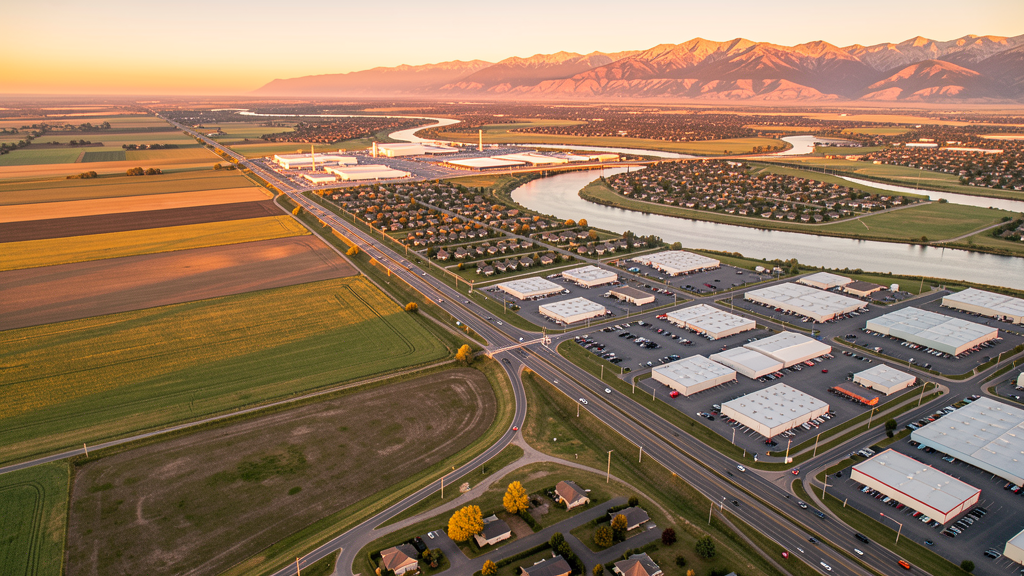
Get Matched With a Local Surveyor
Drone Survey Services Available in Nampa, ID
As Idaho second-largest city and the economic hub of Canyon County, Nampa anchors the western Treasure Valley with industrial expansion along I-84 and a growing downtown revitalization corridor. The city dual-airport environment (Nampa Municipal S67 and proximity to BOI Class C) requires commercial drone operators to manage multiple airspace coordination points. Canyon County growth rate now exceeds Ada County, making Nampa an increasingly important market for aerial survey and construction monitoring services.
Drone Surveys for Nampa's Construction Market
Nampa is experiencing rapid commercial and industrial growth, anchored by the College of Western Idaho campus expansion and the Nampa Gateway Center redevelopment. The Ford Idaho Center area continues to attract development with new hospitality and retail projects along Garrity Boulevard. Downtown Nampa revitalization along First Street South represents multi-million-dollar mixed-use investment. Industrial development along the I-84 Exit 36 corridor has been substantial with multiple distribution and warehouse facilities. Residential permitting in Canyon County exceeded 2,500 new units in 2023.
Active Developers in the Area:

Typical Project Costs in Idaho
Cost ranges are based on market data for Boise City. Actual pricing depends on site size, complexity, and deliverables.
| Service Type | Low End | High End |
|---|---|---|
| Topographic Survey | $1,100 | $4,200 |
| Drone Inspection | $750 | $2,800 |
| LiDAR Scanning | $2,800 | $7,500 |
| Environmental Monitoring | $1,400 | $4,800 |
| Aerial Imagery | $450 | $1,800 |
| Construction Monitoring | $900 | $3,200 |
| Real Estate Photography | $250 | $1,100 |
| Roof Inspection | $350 | $1,400 |
Local Airspace & Regulations in Nampa, ID
FAA Part 107 Requirements
All commercial drone operations in Idaho require the pilot to hold an active FAA Part 107 Remote Pilot Certificate. Our network surveyors are verified Part 107 holders.
State Drone Laws
Idaho Code § 21-801 et seq (Title 21, Chapter 8) governs unmanned aircraft systems statewide. The law prohibits drone surveillance of private property without consent (§ 21-803, $500 civil penalty per violation), bans weaponization of drones (§ 21-804, misdemeanor), and prohibits using drones to interfere with wildfire suppression (§ 21-805). The state preempts local regulation of drone flight paths and airspace (§ 21-810), though cities may regulate takeoff and landing on public property they own. Idaho does not require a separate state-level drone license. Commercial drone operators must hold a valid FAA Part 107 Remote Pilot Certificate. Idaho was one of the first states to pass comprehensive drone legislation in 2013 (HB 279), amended by SB 1133 (2021) to align definitions with the federal Part 107 framework.
Local Ordinances
Nampa City Code prohibits drone takeoff and landing in city parks without a permit from the Nampa Parks and Recreation Department. A Special Event Permit ($75, 14-day processing) is required for commercial drone operations at city events or festivals. Nampa Municipal Airport (S67) requires notification to the airport manager for any drone operations within 3 miles. Canyon County follows state and federal regulations for commercial filming on county property, requiring a right-of-way encroachment permit. Idaho Code section 21-810 preempts Nampa from regulating drone airspace or flight paths.
Restricted Airspace
- BOI Class C outer shelf covers eastern Nampa (10 NM ring, 2,100-4,000 ft MSL). LAANC authorization required for controlled-airspace drone operations in eastern Nampa.
- Nampa Municipal Airport (S67) is a towered GA airport with a 5-mile notification requirement under 14 CFR Part 107.49. Drone operations within 5 NM require tower notification on CTAF 122.825.
- Mountain Home AFB MOA extends over areas southeast of Nampa. Commercial drone pilots must check FAA UAS Facility Maps and coordinate with ATC when operating in advisory airspace.
- Deer Flat National Wildlife Refuge immediately west and southwest of Nampa along the Boise River and Lake Lowell. US Fish and Wildlife Service prohibits drone operations over the refuge without a Special Use Permit (50 CFR section 27.34).
- Seasonal wildfire TFRs in foothills north and east of Nampa, June through October. Check current NOTAMs before flying.
- Nampa City Code prohibits drone takeoff and landing in city parks (Lakeview Park, Lions Park, Centennial Park) without a permit from Nampa Parks and Recreation.
Airports in the area: undefined (undefined), undefined (undefined), undefined (undefined), undefined (undefined)
Why Hire Through Aerius View in Nampa, ID?
FAA-Certified
Every surveyor holds an active Part 107 Remote Pilot Certificate.
Local to Nampa
Surveyors who know the Idaho airspace and local permitting.
No Cost to Quote
Submit your project at no charge. Pay the surveyor directly if you proceed.
Fast Turnaround
A local surveyor contacts you within 2 business days.
How Our Nampa Matching Process Works
We're actively building our network of FAA-certified drone operators in Nampa, ID. Here's exactly what happens when you submit a project request.
Submit Your Project
Tell us your site location, acreage, and what you need (topographic survey, LiDAR, inspection, etc.). Takes 60 seconds. No cost, no obligation.
We Match & Vet
We identify Part 107-certified operators in Idaho with the right equipment for your project. Every pilot is verified for active certification, insurance, and relevant experience in Idaho airspace.
You Get Quotes
Matched surveyors contact you within 2 business days with quotes. You compare pricing, timelines, and deliverables, then choose the right fit. You pay the surveyor directly, no markup.
What Deliverables Do You Get?
Every project includes professional-grade deliverables compatible with standard construction and engineering software:
- Orthomosaic maps (GeoTIFF) for site overview and documentation
- Point clouds (LAS/LAZ) for 3D modeling and volumetric analysis
- DEM/DSM terrain models for cut/fill and grade analysis
- Contour lines (DXF/DWG, CAD-ready) for Civil 3D and Revit
- Progress reports with side-by-side comparisons for construction monitoring
- Coordinate systems matched to your project datum (State Plane, UTM, or local)
Insurance & Liability Protection
Pilot Insurance Required
Every operator in our network must carry active liability insurance. Minimum coverage: $1,000,000 general liability. Proof of insurance is verified before any pilot joins the network.
FAA Part 107 Verified
We confirm each pilot's Remote Pilot Certificate is active and in good standing through the FAA Airmen Inquiry system. Expired certificates are flagged automatically.
Equipment Documentation
Pilots list their drone models, sensors (RGB, LiDAR, thermal, multispectral), and payload specs so we can match the right equipment to your project requirements.
Site Safety Coordination
Pilots coordinate with your site superintendent for safe operations on active construction sites, including flight plans that avoid worker areas and equipment zones.
Nampa, ID Drone Survey FAQs
Can I fly a drone over Deer Flat National Wildlife Refuge near Nampa?
No. The US Fish and Wildlife Service prohibits drone operations over Deer Flat National Wildlife Refuge (including Lake Lowell sections) without a Special Use Permit under 50 CFR section 27.34. The refuge is immediately west of Nampa, so pilots must verify their flight area is outside refuge boundaries.
What airport notification is required for drone flights in Nampa?
Nampa Municipal Airport (S67) is a towered GA airport. Under 14 CFR Part 107.49, drone pilots must notify the S67 tower (CTAF 122.825) for any operations within 5 NM. Eastern Nampa also falls within the BOI Class C outer shelf, requiring LAANC authorization.
How does Nampa growth compare to the rest of the Boise metro?
Nampa is the second-largest city in Idaho at approximately 118,500 residents (2024 estimate), growing at roughly 4% annually. Canyon County as a whole is the fastest-growing county in the metro, with residential permitting exceeding 2,500 units in 2023. Industrial development along the I-84 corridor is a primary driver.
Are there city-specific drone ordinances in Nampa?
Yes. Nampa City Code prohibits drone takeoff and landing in city parks without a permit from Nampa Parks and Recreation. However, under Idaho Code section 21-810 (state preemption), Nampa cannot regulate drone airspace or flight paths, only takeoff and landing locations on city-owned property.
What does a drone roof inspection cost in Nampa?
Drone roof inspection pricing in the Nampa and Canyon County market ranges from $350 to $1,400 depending on roof size, complexity, and deliverables. Thermal imaging adds cost. Turnaround is typically 1-2 business days.
Nearby Cities
Are You a Drone Surveyor in Nampa?
Get pre-qualified leads in your service area. No membership fees, no monthly minimums. First lead free.
Ready to Start Your Project in Nampa, ID?
Get matched with a local, FAA-certified surveyor. No cost, no obligation.
Request a Free Quote