Drone Survey Services in Show Low, AZ
From Show Low Lake second-home development to US-60 tourism infrastructure and post-Wallow Fire forest restoration, Show Low is a 6,345-foot White Mountains community where high altitude, wildfire restrictions, and Apache-Sitgreaves forest boundaries shape every survey mission.
Serving Navajo County & the Show Low area
Request a Free Quote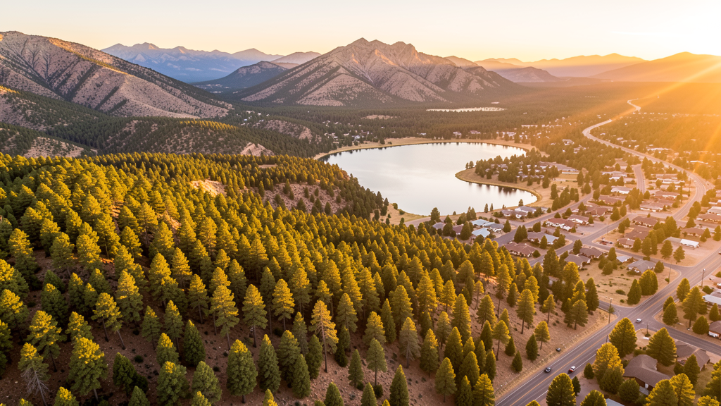
Get Matched With a Local Surveyor
Drone Survey Services Available in Show Low, AZ
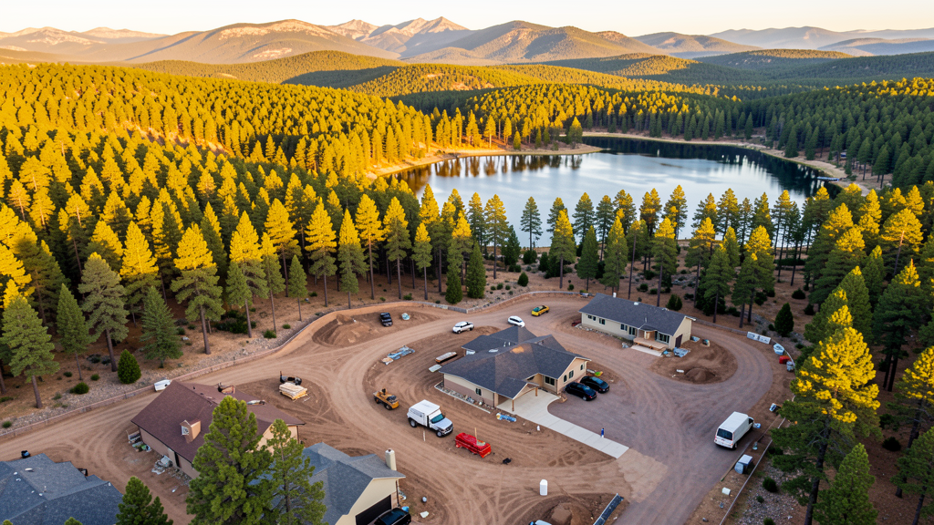
Show Low is a mountain community driven by second-home development, tourism infrastructure, and retirement growth. The US-60 corridor has commercial development. Apache-Sitgreaves National Forest restoration projects after the Wallow Fire generate environmental survey needs. At 6,345 ft, the construction season is shorter.
Drone Surveys for Show Low's Construction Market
Show Low is a mountain community in the White Mountains of Navajo County with a construction market driven by second-home development, tourism infrastructure, and retirement community growth. The town has seen residential development around Show Low Lake and in the Linden area. Commercial development along the US-60 corridor includes retail centers and the Hon-Dah Resort and Casino area. The town serves as a gateway to the White Mountains recreation area, generating seasonal tourism construction demand. Water infrastructure and wildfire mitigation projects are ongoing. The nearby Apache-Sitgreaves National Forest restoration projects after the Wallow Fire generate environmental survey needs. At 6,345 ft elevation, the construction season is shorter than in Phoenix or Tucson.
Active Developers in the Area:
Typical Project Costs in Arizona
Cost ranges are based on market data for Show Low. Actual pricing depends on site size, complexity, and deliverables.
| Service Type | Low End | High End |
|---|---|---|
| Topographic Survey | $2,000 | $5,000 |
| Drone Inspection | $275 | $850 |
| LiDAR Scanning | $3,000 | $9,000 |
| Environmental Monitoring | $850 | $3,200 |
| Aerial Imagery | $175 | $500 |
| Construction Monitoring | $1,300 | $3,200 |
| Real Estate Photography | $175 | $450 |
| Roof Inspection | $250 | $800 |
Local Airspace & Regulations in Show Low, AZ
FAA Part 107 Requirements
All commercial drone operations in Arizona require the pilot to hold an active FAA Part 107 Remote Pilot Certificate. Our network surveyors are verified Part 107 holders.
State Drone Laws
Arizona SB 1449 (2016) was the first state law regulating drone use, prohibiting drone operations that interfere with law enforcement, emergency responders, or wildfire suppression efforts. The law prohibits drone flights within 3 miles of a wildfire or prescribed burn and makes violation a class 1 misdemeanor. ARS Title 13 Chapter 29 Article 3 restricts drone surveillance of private property and weaponization of drones. Commercial operators must hold a valid FAA Part 107 Remote Pilot Certificate. Arizona does not require a separate state drone license, but operators must comply with FAA Part 107 rules and any local ordinances. The Arizona Department of Public Safety maintains guidelines for drone operations near critical infrastructure including power plants, dams, and military installations.
Local Ordinances
Show Low follows Navajo County regulations for drone operations. Commercial operators must hold FAA Part 107 certification. The town does not have a specific drone ordinance but requires a special event permit for drone demonstrations at public events. Apache-Sitgreaves National Forest areas prohibit drone flights in designated wilderness areas. White Mountain Apache Indian Reservation lands require tribal government permission for drone overflights. During wildfire season, operators must comply with Arizona SB 1449 restrictions on flights near wildfires. The town has historically addressed drone complaints through nuisance ordinances. The high altitude requires equipment rated for reduced air density operations.
Restricted Airspace
- Show Low Airport (SOW) is uncontrolled but has general aviation traffic. Drone operators should monitor CTAF 122.8 and maintain visual line of sight.
- Apache-Sitgreaves National Forests surround Show Low. Designated wilderness areas within the forest prohibit drone flights by the US Forest Service.
- White Mountain Apache Indian Reservation lands are south and east of Show Low. Drone flights over tribal land require permission from the tribal government.
- Active wildfire risk area during summer months. Arizona SB 1449 prohibits drone flights within 3 miles of a wildfire or prescribed burn. Violation is a class 1 misdemeanor. The 2011 Wallow Fire, the largest in Arizona history, burned through this region.
- High-altitude operations: Show Low sits at 6,345 ft elevation. Drone performance is significantly reduced due to thinner air. Flight times are 20-25% shorter than at sea level.
Airports in the area: undefined (undefined), undefined (undefined), undefined (undefined)
Why Hire Through Aerius View in Show Low, AZ?
FAA-Certified
Every surveyor holds an active Part 107 Remote Pilot Certificate.
Local to Show Low
Surveyors who know the Arizona airspace and local permitting.
No Cost to Quote
Submit your project at no charge. Pay the surveyor directly if you proceed.
Fast Turnaround
A local surveyor contacts you within 2 business days.
How Our Show Low Matching Process Works
We're actively building our network of FAA-certified drone operators in Show Low, AZ. Here's exactly what happens when you submit a project request.
Submit Your Project
Tell us your site location, acreage, and what you need (topographic survey, LiDAR, inspection, etc.). Takes 60 seconds. No cost, no obligation.
We Match & Vet
We identify Part 107-certified operators in Arizona with the right equipment for your project. Every pilot is verified for active certification, insurance, and relevant experience in Arizona airspace.
You Get Quotes
Matched surveyors contact you within 2 business days with quotes. You compare pricing, timelines, and deliverables, then choose the right fit. You pay the surveyor directly, no markup.
What Deliverables Do You Get?
Every project includes professional-grade deliverables compatible with standard construction and engineering software:
- Orthomosaic maps (GeoTIFF) for site overview and documentation
- Point clouds (LAS/LAZ) for 3D modeling and volumetric analysis
- DEM/DSM terrain models for cut/fill and grade analysis
- Contour lines (DXF/DWG, CAD-ready) for Civil 3D and Revit
- Progress reports with side-by-side comparisons for construction monitoring
- Coordinate systems matched to your project datum (State Plane, UTM, or local)
Insurance & Liability Protection
Pilot Insurance Required
Every operator in our network must carry active liability insurance. Minimum coverage: $1,000,000 general liability. Proof of insurance is verified before any pilot joins the network.
FAA Part 107 Verified
We confirm each pilot's Remote Pilot Certificate is active and in good standing through the FAA Airmen Inquiry system. Expired certificates are flagged automatically.
Equipment Documentation
Pilots list their drone models, sensors (RGB, LiDAR, thermal, multispectral), and payload specs so we can match the right equipment to your project requirements.
Site Safety Coordination
Pilots coordinate with your site superintendent for safe operations on active construction sites, including flight plans that avoid worker areas and equipment zones.
Show Low, AZ Drone Survey FAQs
Do I need a permit for a drone survey in Show Low?
Show Low follows Navajo County regulations. You need a permit only for flights on public property. Surveys from private property with owner permission do not require a town permit. All commercial operations require FAA Part 107 certification.
How does the altitude affect drone operations in Show Low?
Show Low sits at 6,345 feet elevation in the White Mountains. Drone performance is significantly reduced with flight times 20-25% shorter than at sea level. Our local surveyors select equipment rated for high-altitude operations and account for density altitude in mission planning.
Can I fly drones during wildfire season near Show Low?
Arizona SB 1449 prohibits drone flights within 3 miles of a wildfire or prescribed burn. The 2011 Wallow Fire, the largest in Arizona history, burned through this region. Always check for active fire restrictions and TFRs before scheduling survey work during summer months.
Are there tribal land restrictions near Show Low?
The White Mountain Apache Indian Reservation is south and east of Show Low. Drone flights over tribal land require permission from the White Mountain Apache tribal government. Always verify reservation boundaries before flying. Unauthorized flights over tribal land may be treated as trespassing.
What are the main survey needs in Show Low?
Second-home development around Show Low Lake, tourism infrastructure along US-60, water infrastructure improvements, and US Forest Service restoration projects after the Wallow Fire are the primary needs. The shorter construction season at 6,345 ft creates concentrated demand May through October.
Nearby Cities
Are You a Drone Surveyor in Show Low?
Get pre-qualified leads in your service area. No membership fees, no monthly minimums. First lead free.
Ready to Start Your Project in Show Low, AZ?
Get matched with a local, FAA-certified surveyor. No cost, no obligation.
Request a Free Quote