Aerial Imaging Services in Spring Ridge, PA
Golden-hour aerial of the Spring Ridge ridge in Berks County, PA, the Schuylkill River valley below with its floodplain forests, the Penn State Berks campus buildings on the ridge to the northwest, and residential ridge roads tracing the high ground toward Pottstown and Allentown in the distance.
The Reading, PA Metropolitan Statistical Area (Berks County, southeastern Pennsylvania) includes Spring Ridge, where roughly 1,003 residents live in Berks. Spring Ridge is a quiet census-designated place on the Schuylkill River valley rim, population around 1,000, but its airspace is never quiet for long. The Penn State Berks campus occupies the ridge to the northwest and its 258-acre master plan keeps adding academic, residence, and athletics buildings that all need progress documentation and as-built verification. Berks County transportation funds (the $430M West Shore Bypass program) keep crews active on the valley roads and bridge structures, and the Schuylkill floodplain below draws recurring stormwater and levee inspection work. The ridge also hosts growing solar-array applications and transmission corridor easements that generate LiDAR demand for siting analysis.
Serving Berks & the Reading, PA Metropolitan Statistical Area (Berks County, southeastern Pennsylvania) area
Request a Free Quote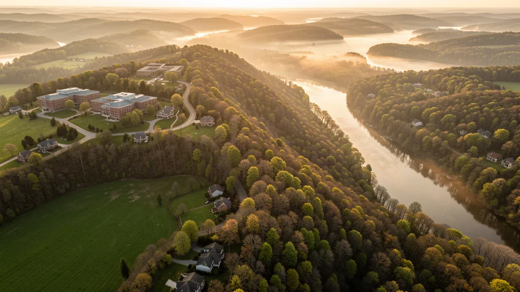
Get Matched With a Local Drone Operator
Spring Ridge Aerial Imaging Options
A ridge in a river valley: the terrain is the story. Most aerial work here is hillside LiDAR for floodplain and solar siting, campus construction monitoring for Penn State Berks, and low-oblique passes over the Schuylkill floodplain where every camera angle fights elevation change. The small population keeps noise complaints down, but the ridgeline line-of-sight boundary makes flight planning the real skill on every job.
Spring Ridge Airspace, FAA Rules & Local Drone Laws
FAA Part 107 Requirements
All commercial drone operations in Pennsylvania require the pilot to hold an active FAA Part 107 Remote Pilot Certificate. Our network operators are verified Part 107 holders.
State Drone Laws
Pennsylvania regulates drone operations under Act 164 of 2018, which establishes a framework for lawful unmanned aircraft use while prohibiting drone surveillance of private property without consent and restricting flights over critical infrastructure. The law prohibits using drones to conduct surveillance of individuals in private settings, defines penalties for reckless operation, and restricts drone use for hunting-related activities. Pennsylvania does not require a separate state-level commercial drone license, but all commercial operators must hold an FAA Part 107 Remote Pilot Certificate, register their aircraft with the FAA, and maintain visual line of sight. Act 164 specifically prohibits drone flights within 250 feet of a person, vehicle, or structure without consent when the operator is operating outside FAA-authorized commercial operations. The Pennsylvania Department of Conservation and Natural Resources (DCNR) requires a permit for commercial drone operations in state parks and state forests. Philadelphia and Pittsburgh have additional local restrictions — Philadelphia prohibits drone takeoff and landing in city parks without a permit. Law enforcement agencies may use drones for search and rescue, accident reconstruction, and emergency response under documented policies.
Local Ordinances
Spring Ridge is a census-designated place inside Spring Township, no standalone municipal drone ordinance applies, so FAA Part 107 and Act 164 set the rules from the federal level. Spring Township has no drone-specific code on the books, but property-based rules still bind: take off and land where you hold the deed or a signed owner permission. Ridge trailheads managed by the county require written permission before launch, and DCNR permits cover any flight crossing state forest. Farmers along the ridge will ask about noise and animal stress, brief neighboring landowners before long-day operations above pasture.
Restricted Airspace
- Reading Regional (RDG) Class D airspace reaches the Reading edge of the metro, about 10 miles southwest of the ridge. Any mapping or photography mission whose track crosses the protected ring needs LAANC approval, request it in B4UFLY before wheels-up and expect green or amber zones, not the red core. Helicopter traffic into RDG runs regularly, watch the local pattern when working the valley floor.
- The ridge itself sits a few hundred feet above the Schuylkill River floodplain on the west bank, so terrain relief is the real planning factor here. Part 105/107 visual line of sight rules push maximum practical altitude well below the ridge top when the controller stands on the flats, plan orbits from high ground or hold the line-of-sight boundary before you climb. The steep forested slopes along the Schuylkill also keep you clear of people and property on the valley floor.
- State park tracts along the lower Schuylkill (Penn State Berks frontage and county forestland on the ridge) carry PA DCNR rules: commercial flight in state parks or state forests requires a DCNR permit, and recreational flying in the most heavily used sections is discouraged. Check the current DCNR drone map before scheduling any work that touches parkland or ridge trail corridors.
- Pennsylvania Act 164 limits low work near people: no flight inside 250 feet of individuals, vehicles, or structures without consent. Spring Ridge is a small CDP with scattered homes along PA-10 and the ridge roads, expect residential setbacks and plan takeoff/landing on the client property itself. Berks County farmland between the ridge and the Reading suburbs adds livestock areas where ground clearance and noise both matter.
- Lehigh Valley International (ABE) sits 40 miles north, its approach corridor is well outside anything a ridge job would cross, and no TFR activity is typical in this sector outside federal flight-check events. Verify NOTAMs on the launch day regardless, county air shows and agricultural spray activity can change the picture in a week.
Airports in the area: RDG, Reading Regional Airport (General Carl A. Spaatz Field), 10 miles southwest of the ridge, general aviation with scheduled helicopter service, Class D airspace with LAANC available, PHL, Philadelphia International Airport, 90 miles east, the nearest major commercial hub, Class B airspace, ABE, Lehigh Valley International Airport, 40 miles north, regional hub with daily commercial service, Class D airspace, LDI, Lansdale Regional Airport, 30 miles northeast, general aviation field in the greater Philadelphia market area
What Drone Services Cost in Pennsylvania
Cost ranges are based on market data for Reading, PA Metropolitan Statistical Area (Berks County, southeastern Pennsylvania). Actual pricing depends on site size, complexity, and deliverables.
| Service Type | Low End | High End |
|---|---|---|
| Topographic Data Collection | $950 | $3,200 |
| Drone Inspection | $300 | $1,200 |
| LiDAR Scanning | $2,000 | $6,000 |
| Environmental Monitoring | $550 | $2,000 |
| Aerial Imagery | $250 | $950 |
| Construction Monitoring | $300 | $1,100 |
| Real Estate Photography | $180 | $450 |
| Roof Inspection | $250 | $600 |
Free cost calculator, ROI calculator, and 14-page buyer's guide. No signup required.
Are you a drone operator serving Spring Ridge? List your business on AeriusView and get pre-qualified leads in your service area.
List Your Business →Spring Ridge Construction & Development: An Aerial Perspective
Spring Ridge is a quiet census-designated place on the Schuylkill River valley rim, population around 1,000, but its airspace is never quiet for long. The Penn State Berks campus occupies the ridge to the northwest and its 258-acre master plan keeps adding academic, residence, and athletics buildings that all need progress documentation and as-built verification. Berks County transportation funds (the $430M West Shore Bypass program) keep crews active on the valley roads and bridge structures, and the Schuylkill floodplain below draws recurring stormwater and levee inspection work. The ridge also hosts growing solar-array applications and transmission corridor easements that generate LiDAR demand for siting analysis.
Active Developers in the Area:
- Penn State Berks, 258-acre academic campus on the ridge, ongoing building replacement, residence hall, and field renovation program
- Berks County / PennDOT District 5, road, bridge, and stormwater work feeding the West Shore Bypass and US 422 corridor in the valley
- Spring Township, municipal capital projects including ridge road resurfacing and stormwater management in the Schuylkill floodplain
- Regional solar siting applicants, array and transmission corridor projects proposed along the ridge and valley rim

Why Spring Ridge Contractors Trust Aerius View
FAA-Certified
Every operator holds an active Part 107 Remote Pilot Certificate.
Local to Spring Ridge
Operators who know the Pennsylvania airspace and local permitting.
No Cost to Quote
Submit your project at no charge. Pay the operator directly if you proceed.
Fast Turnaround
A local operator contacts you within 2 business days.
AeriusView is expanding in Spring Ridge, PA
We are actively onboarding verified aerial data professionals in your area. Submit a project request and we will connect you with a qualified expert soon.
Request a QuoteWhat Aerial Data Products Do You Receive in Spring Ridge?
Every project includes professional-grade deliverables compatible with standard construction and engineering software:
- Orthomosaic maps (GeoTIFF) for site overview and documentation
- Point clouds (LAS/LAZ) for 3D modeling and volumetric analysis
- DEM/DSM terrain models for cut/fill and grade analysis
- Contour lines (DXF/DWG, CAD-ready) for Civil 3D and Revit
- Progress reports with side-by-side comparisons for construction monitoring
- Coordinate systems matched to your project datum (State Plane, UTM, or local)
Insurance & Liability Protection
Pilot Insurance Required
Every operator in our network must carry active liability insurance. Minimum coverage: $1,000,000 general liability. Proof of insurance is verified before any pilot joins the network.
FAA Part 107 Verified
We confirm each pilot's Remote Pilot Certificate is active and in good standing through the FAA Airmen Inquiry system. Expired certificates are flagged automatically.
Equipment Documentation
Pilots list their drone models, sensors (RGB, LiDAR, thermal, multispectral), and payload specs so we can match the right equipment to your project requirements.
Site Safety Coordination
Pilots coordinate with your site superintendent for safe operations on active construction sites, including flight plans that avoid worker areas and equipment zones.
Spring Ridge, PA Drone & Aerial Imaging Questions
How steep is the terrain, and how does it change the flight plan?
The ridge rises roughly 700-900 feet above the Schuylkill floodplain, which means visual line of sight sets your ceiling: from the valley floor you can rarely exceed 300-400 feet AGL before losing sight of the aircraft behind the rise. Practically, crews stage on the ridge or fly low-oblique passes over the flats. Slopes above 25 degrees make LiDAR oblique correction the real cost driver on hillside parcels, budget for ground control points at multiple elevations.
What does a topographic survey of a hillside farm or campus parcel cost here?
Expect $950 for a flat lot under 5 acres, scaling to $3,200 for a ridge parcel over 20 acres or a campus plot with steep sides. LiDAR densification for floodplain or transmission siting runs $2,000 to $6,000 depending on coverage and ground control density. Routine inspection visits land at $300 to $1,200, and real estate packages for ridge homes run $180 to $450.
Is the Penn State Berks area off limits to commercial drones?
Not off limits, but campus policy is real: Penn State publishes a UAS policy that generally requires campus notification and sometimes site approval for commercial flight on university property. For off-campus work over the ridge near the campus, standard Part 107 and LAANC (inside RDG Class D tracks) apply without a campus letter. Confirm the specific parcel owner before any takeoff inside the 258-acre campus boundary, the athletics complex and residence halls carry the densest people patterns.
Does the Schuylkill River below the ridge count as restricted airspace?
The river channel itself is not a TFR, but the floodplain below it is where people, trails, and watercraft concentrate, that is a Part 107 over-people problem rather than a map problem. Keep passes above the trail and boat ramp corridors, and if your survey must overfly the waterway, hold visual line of sight on both the drone and the nearest person. Winter adds roosting waterfowl to the river corridor, check with the county before low passes in the roost season.
What should a contract include for ridgeline work in this area?
Three items show up on every ridge job: a written line-of-sight boundary acknowledging that terrain, not altitude, is the limit, adjacent landowner notification for anything above pasture or over ridge trails, and a data-delivery spec that states the vertical datum (NAVD88) and ground control density, because hillside LiDAR without multi-elevation control is worth half its price. Standard insurance and Part 107 certificate language are baseline, not extras.
How close is Reading Regional Airport to a typical Spring Ridge launch point?
RDG sits about 10 miles southwest across the valley. Most residential launches in Spring Ridge fall outside the Class D ring and need no authorization beyond a B4UFLY check. Launch points that move toward Reading, campus edges, the valley road grid, fall inside or on the ring edge and will return a LAANC color code in the app. Green means fly, amber means altitude-capped, red core means TFR-like restriction. Re-check the day of flight because temporary NOTAMs do appear for air shows and military events in the sector.
Key Aerial Imaging Terms
New to aerial imaging? These essential terms will help you understand your project deliverables.
Ground Sample Distance
The spatial resolution of drone imagery, measured in cm/pixel.
Orthomosaic
A geometrically corrected aerial photo map stitched from many images.
Point Cloud
A 3D dataset of points representing the captured surface.
Real-Time Kinematic
RTK GPS correction for centimeter-level positional accuracy.
LiDAR
Laser scanning that captures terrain through vegetation.
Digital Elevation Model
A 3D representation of terrain elevation across the site.
Ground Control Point
Known reference markers used to anchor and validate mapping accuracy.
Aerial Mapping
Data collection from above to map and measure a site.
Are You a Drone Operator in Spring Ridge?
Get pre-qualified leads in your service area. No membership fees, no monthly minimums. First lead free.
Ready to Start Your Project in Spring Ridge, PA?
Get matched with a local, FAA-certified drone operator. No cost, no obligation.
Request a Free QuoteAeriusView connects clients with FAA-certified drone operators. Services are not licensed land surveying. Deliverables are not authoritative for boundary determination, design, or legal purposes.