Drone Survey Services in Surprise, AZ
From Sun City Grand and Surprise Farms residential developments to the Loop 303 corridor industrial growth and westward desert expansion, Surprise is one of the fastest-growing cities in the Phoenix metro with population growing from 30,000 to 155,000 since 2000.
Serving Maricopa County & the Phoenix-Mesa-Chandler area
Request a Free Quote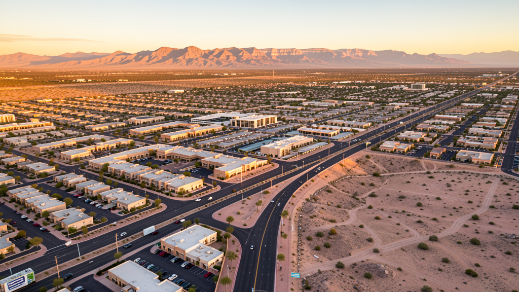
Get Matched With a Local Surveyor
Drone Survey Services Available in Surprise, AZ
Surprise sits in northwestern Maricopa County with 155,000 residents, one of the fastest-growing cities in the Phoenix metro. The city has grown from 30,000 to over 155,000 since 2000. The Loop 303 freeway corridor is driving westward expansion and industrial development. Luke Air Force Base is 5 miles to the south with restricted military airspace. Major residential developments include Sun City Grand and Surprise Farms. The White Tank Mountains border the city to the west.
Drone Surveys for Surprise's Construction Market
Surprise is one of the fastest-growing cities in the Phoenix metro, with population growing from 30,000 to over 155,000 since 2000. The city is expanding westward into the desert along the Loop 303 freeway. Major developments include Sun City Grand, Surprise Farms, and several master-planned communities along Bell Road and Greenway Road. The Surprise Center area is the civic and commercial core with ongoing development. The Loop 303 corridor is attracting industrial and logistics development. Luke Air Force Base to the south creates military airspace coordination requirements.
Active Developers in the Area:
Typical Project Costs in Arizona
Cost ranges are based on market data for Phoenix-Mesa-Chandler. Actual pricing depends on site size, complexity, and deliverables.
| Service Type | Low End | High End |
|---|---|---|
| Topographic Survey | $1,800 | $4,500 |
| Drone Inspection | $250 | $850 |
| LiDAR Scanning | $2,800 | $8,000 |
| Environmental Monitoring | $800 | $3,000 |
| Aerial Imagery | $175 | $500 |
| Construction Monitoring | $1,100 | $3,200 |
| Real Estate Photography | $150 | $450 |
| Roof Inspection | $200 | $750 |
Local Airspace & Regulations in Surprise, AZ
FAA Part 107 Requirements
All commercial drone operations in Arizona require the pilot to hold an active FAA Part 107 Remote Pilot Certificate. Our network surveyors are verified Part 107 holders.
State Drone Laws
Arizona SB 1449 (2016) was the first state law regulating drone use, prohibiting drone operations that interfere with law enforcement, emergency responders, or wildfire suppression efforts. The law prohibits drone flights within 3 miles of a wildfire or prescribed burn and makes violation a class 1 misdemeanor. ARS Title 13 Chapter 29 Article 3 restricts drone surveillance of private property and weaponization of drones. Commercial operators must hold a valid FAA Part 107 Remote Pilot Certificate. Arizona does not require a separate state drone license, but operators must comply with FAA Part 107 rules and any local ordinances. The Arizona Department of Public Safety maintains guidelines for drone operations near critical infrastructure including power plants, dams, and military installations.
Local Ordinances
Surprise follows Maricopa County regulations and FAA Part 107 rules. No city-specific drone permit is required for operations from private property. Phoenix Goodyear Airport Class D airspace is only 5 miles south, requiring LAANC authorization. Luke Air Force Base is 5 miles south with restricted military airspace requiring coordination. The city prohibits drone takeoff/landing in parks without a permit. White Tank Mountain Regional Park has additional restrictions. Surprise is one of the fastest-growing cities in the Phoenix metro.
Restricted Airspace
- Class D airspace around Phoenix Goodyear Airport (GYR) — requires LAANC authorization within 4 nautical miles. GYR is only 5 miles S.
- Class D airspace around Phoenix Deer Valley Airport (DVT) — requires LAANC authorization within 4 nautical miles. DVT is 12 miles E.
- Surprise city parks prohibit drone takeoff/landing without a special use permit. The White Tank Mountain Regional Park has additional restrictions.
- Luke Air Force Base is 5 miles south of Surprise with restricted military airspace. Drone flights near the base require coordination with base operations.
Airports in the area: undefined (undefined), undefined (undefined), undefined (undefined), undefined (undefined)
Why Hire Through Aerius View in Surprise, AZ?
FAA-Certified
Every surveyor holds an active Part 107 Remote Pilot Certificate.
Local to Surprise
Surveyors who know the Arizona airspace and local permitting.
No Cost to Quote
Submit your project at no charge. Pay the surveyor directly if you proceed.
Fast Turnaround
A local surveyor contacts you within 2 business days.
How Our Surprise Matching Process Works
We're actively building our network of FAA-certified drone operators in Surprise, AZ. Here's exactly what happens when you submit a project request.
Submit Your Project
Tell us your site location, acreage, and what you need (topographic survey, LiDAR, inspection, etc.). Takes 60 seconds. No cost, no obligation.
We Match & Vet
We identify Part 107-certified operators in Arizona with the right equipment for your project. Every pilot is verified for active certification, insurance, and relevant experience in Arizona airspace.
You Get Quotes
Matched surveyors contact you within 2 business days with quotes. You compare pricing, timelines, and deliverables, then choose the right fit. You pay the surveyor directly, no markup.
What Deliverables Do You Get?
Every project includes professional-grade deliverables compatible with standard construction and engineering software:
- Orthomosaic maps (GeoTIFF) for site overview and documentation
- Point clouds (LAS/LAZ) for 3D modeling and volumetric analysis
- DEM/DSM terrain models for cut/fill and grade analysis
- Contour lines (DXF/DWG, CAD-ready) for Civil 3D and Revit
- Progress reports with side-by-side comparisons for construction monitoring
- Coordinate systems matched to your project datum (State Plane, UTM, or local)
Insurance & Liability Protection
Pilot Insurance Required
Every operator in our network must carry active liability insurance. Minimum coverage: $1,000,000 general liability. Proof of insurance is verified before any pilot joins the network.
FAA Part 107 Verified
We confirm each pilot's Remote Pilot Certificate is active and in good standing through the FAA Airmen Inquiry system. Expired certificates are flagged automatically.
Equipment Documentation
Pilots list their drone models, sensors (RGB, LiDAR, thermal, multispectral), and payload specs so we can match the right equipment to your project requirements.
Site Safety Coordination
Pilots coordinate with your site superintendent for safe operations on active construction sites, including flight plans that avoid worker areas and equipment zones.
Surprise, AZ Drone Survey FAQs
Do I need a permit for a drone survey in Surprise?
No city-specific permit is required for commercial drone operations from private property in Surprise. Phoenix Goodyear Airport Class D airspace is 5 miles south, and Luke Air Force Base is also 5 miles south with restricted military airspace. Both require coordination. Takeoff/landing in city parks requires a permit.
How much does a drone survey cost in Surprise, AZ?
Topographic surveys in Maricopa County typically range from $1,800 to $4,500. Roof inspections run $200-$750. LiDAR scanning for residential or commercial sites costs $2,800-$8,000. Real estate drone photography starts at $150.
Can I fly a drone near Luke Air Force Base from Surprise?
Luke Air Force Base is only 5 miles south of Surprise with restricted military airspace. Drone flights near the base require coordination with base operations. Phoenix Goodyear Airport Class D airspace is also 5 miles south. Our surveyors handle all military and FAA coordination.
What construction projects need drone surveys in Surprise?
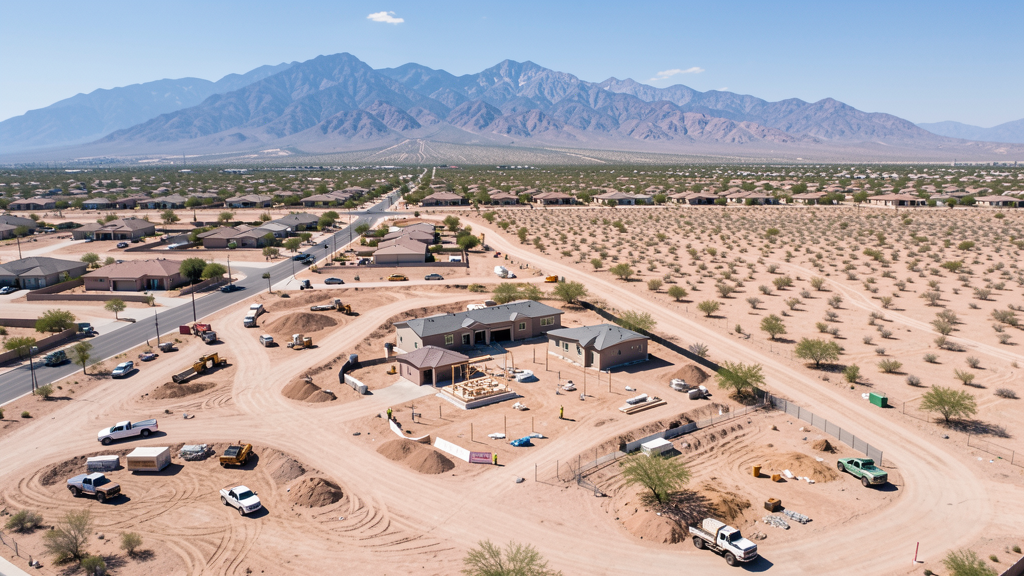
Sun City Grand, Surprise Farms, and master-planned communities along Bell Road and Greenway Road, Loop 303 corridor industrial and logistics development, Surprise Center civic and commercial construction, and westward desert residential expansion all require aerial surveys. Surprise has grown from 30,000 to over 155,000 residents since 2000.
How does desert terrain affect drone surveys in Surprise?
Surprise extends westward into flat to gently rolling desert terrain. The White Tank Mountains to the west create localized wind patterns. Summer temperatures exceeding 110 degrees reduce battery life 20-30%. The flat terrain is ideal for aerial surveys when heat and military airspace coordination are managed. Our surveyors account for all factors in flight planning.
Nearby Cities
Are You a Drone Surveyor in Surprise?
Get pre-qualified leads in your service area. No membership fees, no monthly minimums. First lead free.
Ready to Start Your Project in Surprise, AZ?
Get matched with a local, FAA-certified surveyor. No cost, no obligation.
Request a Free Quote