Aerial Imaging Services in Wilmington, DE
Wilmington golden-hour aerial showing the Christina River winding through downtown with the Riverfront East development site visible along the east bank, the I-95 bridge spanning the river, and the Brandywine Creek valley to the north against the flat Delaware coastal plain.
With about 70,000 people in New Castle County, Wilmington is a community in the Philadelphia-Camden-Wilmington, PA-NJ-DE-MD MSA (Wilmington division — New Castle County, Delaware, with economic ties to the greater Philadelphia metro area of 6.25 million people along the I-95 Northeast Corridor) of Delaware. Wilmington is the largest city in Delaware (population 70,000) and the economic anchor of New Castle County. The 86-acre Riverfront East waterfront redevelopment, downtown office-to-residential conversions, and I-95 infrastructure projects drive a strong construction market. Wilmington corporate law incorporation makes it a center for business headquarters, creating steady demand for commercial building inspection and facility management aerial imaging. The ILG Class D and PHL Class B airspace overlap, combined with Delaware National Guard C-130 operations, make airspace coordination essential for compliant drone operations.
Serving New Castle County & the Philadelphia-Camden-Wilmington, PA-NJ-DE-MD MSA (Wilmington division — New Castle County, Delaware, with economic ties to the greater Philadelphia metro area of 6.25 million people along the I-95 Northeast Corridor) area
Request a Free Quote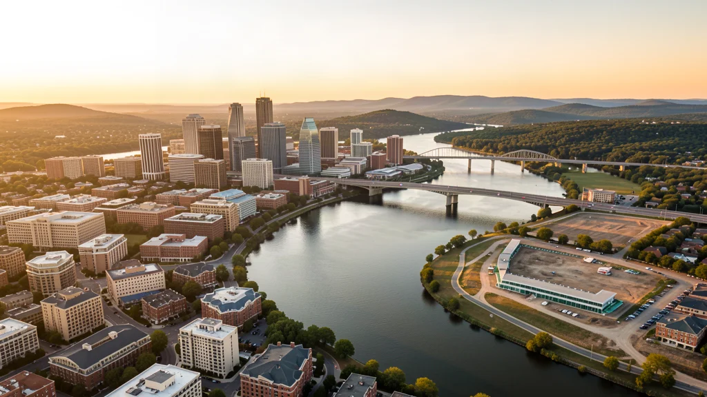
Find a New Castle County Drone Pilot
Aerial Imaging Services Available in Wilmington, DE
Wilmington is the largest city in Delaware (population 70,000) and the economic anchor of New Castle County. The 86-acre Riverfront East waterfront redevelopment, downtown office-to-residential conversions, and I-95 infrastructure projects drive a strong construction market. Wilmington corporate law incorporation makes it a center for business headquarters, creating steady demand for commercial building inspection and facility management aerial imaging. The ILG Class D and PHL Class B airspace overlap, combined with Delaware National Guard C-130 operations, make airspace coordination essential for compliant drone operations.
Airspace & Flying Rules in Wilmington, DE
FAA Part 107 Requirements
Commercial flights over Wilmington fall under FAA Part 107: the pilot must hold a current Remote Pilot Certificate. Network operators are checked before matching.
State Drone Laws
Drone rules in Wilmington layer two ways: Wilmington is governed by Delaware state drone law (Delaware Code Title 21 Section 4601 et seq, HB 340 Delaware Drone Privacy Protection Act, SB 162 UAS registration) and FAA Part 107 regulations. plus Delaware statewide UAS law (DE Code Title 21 § 4601 et seq; HB 340 (2016, Drone Privacy Protection Act); SB 162 (2019, UAS law enforcement guidelines); FAA Part 107; FAA LAANC; 49 USC § 40103) governing commercial flights. Full Delaware drone law →
Local Ordinances
Wilmington is governed by Delaware state drone law (Delaware Code Title 21 Section 4601 et seq, HB 340 Delaware Drone Privacy Protection Act, SB 162 UAS registration) and FAA Part 107 regulations. The City of Wilmington requires a permit for commercial drone takeoff and landing on city property, issued through the Wilmington Department of Parks and Recreation. Wilmington city parks including Brandywine Park, Rockford Park, and Tubman-Garrett Riverfront Park require explicit permission for commercial drone operations. The Christina Riverfront and Riverfront East development area is managed by the Riverfront Development Corporation and requires authorization for commercial drone filming. New Castle County parks require a commercial use permit. Delaware State Parks (including Fox Point State Park and Brandywine Creek State Park) require a permit from the Delaware Division of Parks and Recreation. Commercial drone filming for movies, TV, or advertising requires a film permit from the Delaware Film Office. FAA Part 107 Remote Pilot Certification is required for all commercial operations. LAANC authorization is required for flights within ILG Class D or PHL Class B airspace boundaries. The Port of Wilmington has maritime security restrictions under MTSA regulations. The Delaware Memorial Bridge (I-295) is under the jurisdiction of the Delaware River and Bay Authority, which restricts drone operations near the bridge structure.
Restricted Airspace
- Wilmington Airport (ILG) has Class D airspace with a 4 NM radius surface area, located approximately 5 NM south of downtown Wilmington. The airport hosts the Delaware Army National Guard and Delaware Air National Guard, which operate helicopter and C-130 aircraft respectively. Commercial drone operations within the ILG Class D require LAANC authorization. The airport also serves Avelo Airlines commercial passenger flights, creating mixed military, commercial, and GA traffic. The Delaware National Guard helicopter operations from ILG create low-altitude traffic patterns along the Christina River corridor.
- Philadelphia International Airport (PHL) Class B airspace extends over northern Delaware, including portions of New Castle County north of Wilmington. The PHL Class B surface area begins approximately 20 NM northeast of downtown Wilmington, but the outer shelves extend over the Wilmington area at higher altitudes. Commercial drone operations in northern New Castle County should check PHL Class B boundaries, as the outer area can affect flights above 200 feet AGL in the northern parts of the Wilmington metro. PHL is a major international hub with heavy airline and cargo traffic — US Airways/American Airlines hub operations create continuous jet traffic.
- New Castle Airport (N99/ILG complex) has Class D airspace with Delaware Air National Guard C-130 Hercules operations. The 166th Airlift Wing conducts heavy airlift training in the Delaware Valley region, and drone operators in the New Castle area should check N99 Class D boundaries and NOTAMs for military flight activity. The C-130s conduct low-level training routes over Delaware Bay and the Delaware River corridor. The proximity of both ILG and N99 controlled airspace areas means much of the Wilmington-to-New Castle corridor requires LAANC authorization.
- Dover Air Force Base (DOV) is located approximately 45 NM south of Wilmington and has Class C airspace with active C-5 Galaxy and C-17 Globemaster III heavy airlift operations. While DOV is outside the immediate Wilmington area, the military training routes and refueling tracks extend over portions of central Delaware. The 436th and 512th Airlift Wings conduct operations that create low-altitude heavy aircraft traffic over Delaware. Drone operators in southern New Castle County should check DOV Class C boundaries. The Dover AFB Air Mobility Command Museum and the adjacent mortuary affairs facility have security restrictions on aerial photography.
- The Port of Wilmington on the Christina River has maritime security zone restrictions. The port handles cargo ships, automobile imports, and bulk freight, creating commercial vessel traffic on the Christina and Delaware River. The Delaware River itself is a major shipping channel with deep-draft vessel traffic, tug and barge operations, and pilot boat traffic. Drone operators flying near the riverfront, the Delaware Memorial Bridge, and the Port of Wilmington should maintain awareness of low-altitude helicopter traffic from news, medevac, and Coast Guard aviation units. The I-495 and I-95 bridges over the Christina River have infrastructure security considerations.
Airports in the area: ILG — Wilmington Airport (Class D airspace, approximately 5 NM south of downtown — Delaware National Guard base with Army and Air Guard units, commercial service via Avelo Airlines, LAANC available), PHL — Philadelphia International Airport (Class B airspace, approximately 25 NM northeast — major international hub and the primary commercial airport for the Delaware Valley, LAANC available but restricted altitudes in the Class B surface area), N99 — New Castle Airport (Class D airspace, approximately 10 NM south — Delaware Air National Guard C-130 Hercules operations and GA traffic, LAANC available), MQS — Summit Airport (uncontrolled GA airspace, approximately 20 NM south near Middletown — no tower, CTAF operations, check for nearby Dover AFB airspace to the south), DOV — Dover Air Force Base (Class C airspace, approximately 45 NM south — C-5 Galaxy and C-17 Globemaster III heavy airlift operations, restricted military airspace, coordinate with base operations)
Delaware Aerial Imaging Cost Guide
Pricing below reflects the Philadelphia-Camden-Wilmington, PA-NJ-DE-MD MSA (Wilmington division — New Castle County, Delaware, with economic ties to the greater Philadelphia metro area of 6.25 million people along the I-95 Northeast Corridor) market. Site size, terrain, and the deliverables you need move the final number up or down.
| Service Type | Low End | High End |
|---|---|---|
| Topographic Data Collection | $900 | $3,550 |
| Drone Inspection | $300 | $1,550 |
| LiDAR Scanning | $1,825 | $5,550 |
| Environmental Monitoring | $450 | $2,250 |
| Aerial Imagery | $250 | $1,000 |
| Construction Monitoring | $300 | $1,400 |
| Real Estate Photography | $200 | $500 |
| Roof Inspection | $225 | $700 |
Free cost calculator, ROI calculator, and 14-page buyer's guide. No signup required.
Are you a drone operator serving Wilmington? List your business on AeriusView and get pre-qualified leads in your service area.
List Your Business →Aerial Imaging Solutions for Wilmington's Development Pipeline
Wilmington is the largest city in Delaware (population 70,000) and the economic anchor of New Castle County. The city has an active construction market driven by waterfront redevelopment, corporate office renovation, residential conversion, and infrastructure investment. The flagship project is Riverfront East — an 86.3-acre mixed-use development along the east side of the Christina River, adjacent to the existing Christina Riverfront. The project will create thousands of construction jobs and include residential, commercial, retail, and recreational space, with the Wilmington Riverfront Transportation Infrastructure Project providing multi-modal connectivity. The original Riverfront development (Frawley Stadium, Delaware Children Museum, Dupont Environmental Education Center) is being expanded eastward. Downtown Wilmington is seeing office-to-residential conversions as corporate employment patterns shift — DuPont, Chemours, and Incyte Corporation maintain headquarters or major operations in the city. The Christina Riverfront Residences project at the Constitution Yards site will add 300-400 new residents. Amtrak Northeast Corridor infrastructure investment includes the Wilmington Train Station area redevelopment. The I-95 corridor through Wilmington is undergoing bridge rehabilitation and highway modernization. New Castle County building permit values exceeded $400 million in 2024, with strong growth in multifamily residential and mixed-use construction. Delaware corporate law makes Wilmington a center for business incorporation, driving commercial office and professional services construction demand.
Active Developers in the Area:
- Riverfront Development Corporation (state-chartered developer managing the Christina Riverfront East — 86.3-acre mixed-use development, the largest active waterfront redevelopment project in Delaware)
- The Buccini/Pollin Group (Wilmington-based developer with major downtown Wilmington office, residential, and hotel projects including the Residences at Midtown Park and the Westin Wilmington)
- Pettinaro Company (Delaware developer with residential and commercial projects including the 76ers Fieldhouse sports complex and Riverfront commercial buildings)
- BPG Properties / The Duffield Companies (Brandywine Valley developer with office, residential, and mixed-use projects across New Castle County)
- Incyte Corporation (biotechnology company with expanding Wilmington headquarters campus — research labs, office buildings, and parking infrastructure)
- Chemours Company (Fortune 500 specialty chemicals company with Wilmington headquarters and ongoing facilities renovation following the DuPont spinoff)

Why Developers in Wilmington Use Aerius View
FAA-Certified
Every operator holds an active Part 107 Remote Pilot Certificate.
Local to Wilmington
Local crews covering Wilmington and 4 surrounding cities, already current on Delaware airspace and LAANC workflows.
No Cost to Quote
Submit your project at no charge. Pay the operator directly if you proceed.
Fast Turnaround
Quotes in Wilmington commonly move inside 2 business days once your request is in.
AeriusView is expanding in Wilmington, DE
We're onboarding Wilmington operators to serve demand from Riverfront Development Corporation and other area projects. Your request gets matched to verified coverage in New Castle County.
Request a QuoteYour Project Deliverables Explained
Every deliverable below ships with your Wilmington project, formatted for the construction and engineering platforms used throughout the Philadelphia-Camden-Wilmington, PA-NJ-DE-MD MSA (Wilmington division — New Castle County, Delaware, with economic ties to the greater Philadelphia metro area of 6.25 million people along the I-95 Northeast Corridor). Projects like those delivered for Riverfront Development Corporation across New Castle County need data that drops straight into their workflow.
- Point clouds (LAS/LAZ) for 3D modeling and volumetric analysis
- DEM/DSM terrain models for cut/fill and grade analysis
- Contour lines (DXF/DWG, CAD-ready) for Civil 3D and Revit
- Progress reports with side-by-side comparisons for construction monitoring
- Orthomosaic maps (GeoTIFF) for site overview and documentation
- Coordinate systems matched to your project datum — the Delaware State Plane zone, UTM, or a local datum your surveyor specifies
Insurance & Liability Protection
Pilot Insurance Required
Every operator matched to a Wilmington project carries active liability insurance — minimum $1,000,000 general liability, verified from the certificate before the pilot joins the network. Wilmington is governed by Delaware state drone law (Delaware Code Title 21 Section 4601 et seq, HB 340 Delaware Drone Privacy Protection Act, SB 162 UAS registration) and FAA Part 107 regulations. The City of Wilmington requires a permit for commercial drone takeoff and landing on city property, issued through the Wilmington Department of Parks and Recreation. Wilmington city parks including Brandywine Park, Rockford Park, and Tubman-Garrett Riverfront Park require explicit permission for commercial drone operations. The Christina Riverfront and Riverfront East development area is managed by the Riverfront Development Corporation and requires authorization for commercial drone filming. New Castle County parks require a commercial use permit. Delaware State Parks (including Fox Point State Park and Brandywine Creek State Park) require a permit from the Delaware Division of Parks and Recreation. Commercial drone filming for movies, TV, or advertising requires a film permit from the Delaware Film Office. FAA Part 107 Remote Pilot Certification is required for all commercial operations. LAANC authorization is required for flights within ILG Class D or PHL Class B airspace boundaries. The Port of Wilmington has maritime security restrictions under MTSA regulations. The Delaware Memorial Bridge (I-295) is under the jurisdiction of the Delaware River and Bay Authority, which restricts drone operations near the bridge structure.
FAA Part 107 Verified
Each pilot's Remote Pilot Certificate is checked against the FAA Airmen Inquiry before they can serve New Castle County bookings. Expired certificates are flagged automatically.
Equipment Documentation
Pilots register their airframes and sensors (RGB, LiDAR, thermal, multispectral) so Wilmington requests route to crews with the right payload for the job.
Site Safety Coordination
Pilots coordinate with your site superintendent for safe operations on active Wilmington construction sites, including flight plans that avoid worker areas and equipment zones. Wilmington is governed by Delaware state drone law (Delaware Code Title 21 Section 4601 et seq, HB 340 Delaware Drone Privacy Protection Act, SB 162 UAS registration) and FAA Part 107 regulations. The City of Wilmington requires a permit for commercial drone takeoff and landing on city property, issued through the Wilmington Department of Parks and Recreation. Wilmington city parks including Brandywine Park, Rockford Park, and Tubman-Garrett Riverfront Park require explicit permission for commercial drone operations. The Christina Riverfront and Riverfront East development area is managed by the Riverfront Development Corporation and requires authorization for commercial drone filming. New Castle County parks require a commercial use permit. Delaware State Parks (including Fox Point State Park and Brandywine Creek State Park) require a permit from the Delaware Division of Parks and Recreation. Commercial drone filming for movies, TV, or advertising requires a film permit from the Delaware Film Office. FAA Part 107 Remote Pilot Certification is required for all commercial operations. LAANC authorization is required for flights within ILG Class D or PHL Class B airspace boundaries. The Port of Wilmington has maritime security restrictions under MTSA regulations. The Delaware Memorial Bridge (I-295) is under the jurisdiction of the Delaware River and Bay Authority, which restricts drone operations near the bridge structure.
Frequently Asked Questions — Wilmington Aerial Imaging
Do I need LAANC authorization to fly a drone in Wilmington?
Wilmington Airport (ILG) has Class D airspace with a 4 NM radius approximately 5 NM south of downtown, covering the Christina River corridor and the Port of Wilmington. Commercial drone operations within the ILG Class D require LAANC authorization. New Castle Airport (N99) also has Class D airspace approximately 10 NM south, and Philadelphia International (PHL) Class B outer shelves extend over northern New Castle County. Check all three airspace areas and use the FAA B4UFLY app before any flight in the Wilmington area. ILG also hosts Delaware National Guard helicopter and C-130 operations, creating additional low-altitude traffic.
What is the cost of aerial imaging for a construction site in Wilmington?
Topographic drone data collection in Wilmington typically ranges from $900 to $3,500 depending on acreage, terrain, and proximity to ILG Class D airspace or the Christina Riverfront. Construction monitoring visits cost $300 to $1,400 per session. LiDAR scanning runs $1,800 to $5,500. The 86-acre Riverfront East development, downtown office-to-residential conversions, and I-95 infrastructure projects create diverse demand for aerial mapping and progress documentation.
Are there special airspace restrictions near the Port of Wilmington?
The Port of Wilmington on the Christina River has Maritime Transportation Security Act (MTSA) maritime security zone restrictions. The port handles cargo ships, automobile imports, and bulk freight. Commercial drone operators should coordinate with port security before flying near the facility. The Christina River and Delaware River are major shipping channels with deep-draft vessel traffic, tugs, and pilot boats. The Delaware Memorial Bridge (I-295) is under the Delaware River and Bay Authority, which restricts drone operations near the bridge structure.
Can I fly a drone in Brandywine Park or Rockford Park in Wilmington?
Wilmington city parks including Brandywine Park, Rockford Park, and Tubman-Garrett Riverfront Park require authorization from the Wilmington Department of Parks and Recreation for commercial drone takeoff and landing. The Christina Riverfront area is managed by the Riverfront Development Corporation and requires authorization for commercial drone filming. Delaware State Parks including Fox Point State Park and Brandywine Creek State Park require a permit from the Delaware Division of Parks and Recreation. FAA Part 107 prohibits flying directly over non-participants.
What aerial imaging opportunities exist at the Riverfront East development?
Riverfront East is an 86.3-acre mixed-use development along the east side of the Christina River — the largest active waterfront redevelopment project in Delaware. The project requires extensive drone aerial imaging for site grading, foundation excavation, structural inspection, and construction progress documentation. The Wilmington Riverfront Transportation Infrastructure Project component includes road, bridge, and multi-modal infrastructure construction. Commercial operators should coordinate with the Riverfront Development Corporation and check for ILG Class D airspace and Christina River vessel traffic. The project will create thousands of construction jobs through completion.
How does Wilmington corporate presence affect drone survey demand?
Wilmington is a center for corporate incorporation and headquarters operations — DuPont, Chemours, Incyte Corporation, and hundreds of registered corporations maintain offices in the city. The corporate office market creates demand for building facade inspections, roof inspections, and site documentation for facility management. The office-to-residential conversion trend downtown also drives demand for structural inspection and progress monitoring aerial imaging. The Amtrak Wilmington Station area is seeing transit-oriented development that requires aerial site documentation.
Aerial Imaging Terms for Wilmington Projects
Understand what Wilmington drone operators mean when they quote orthomosaics, point clouds, and more. Most Wilmington projects in our cost table start around $200.
Real-Time Kinematic
RTK GPS correction for centimeter-level positional accuracy.
LiDAR
Laser scanning that captures terrain through vegetation.
Digital Elevation Model
A 3D representation of terrain elevation across the site.
Ground Control Point
Known reference markers used to anchor and validate mapping accuracy.
Aerial Mapping
Data collection from above to map and measure a site.
Volumetrics
Cut/fill and stockpile volume calculations derived from terrain models.
Thermal Imaging
Infrared capture that reveals heat signatures for inspections.
Multispectral
Band-specific imagery used for vegetation and crop analysis.
Nearby Cities
Are You a Drone Operator in Wilmington?
Construction and real-estate demand in Wilmington grows every quarter. Get pre-qualified leads in your service area — first one free.
Ready to Start Your Project in Wilmington, DE?
Free matching with FAA-verified pilots across New Castle County and the Philadelphia-Camden-Wilmington, PA-NJ-DE-MD MSA (Wilmington division — New Castle County, Delaware, with economic ties to the greater Philadelphia metro area of 6.25 million people along the I-95 Northeast Corridor). Projects in New Castle County start around $200.
Request a Free QuoteAeriusView connects clients with FAA-certified drone operators. Services are not licensed land surveying. Deliverables are not authoritative for boundary determination, design, or legal purposes.