Drone Survey Services in Cypress, TX
From the 11,400-acre Bridgeland master-planned community to Towne Lake and the US 290 expansion corridor, Cypress is one of Houston's fastest-growing residential zones and a hotbed for topographic surveys and construction monitoring.
Serving Harris County & the Houston-The Woodlands-Sugar Land area
Request a Free Quote
Get Matched With a Local Surveyor
Drone Survey Services Available in Cypress, TX
The Houston-The Woodlands-Sugar Land metro is the largest or second-largest construction market in the US, and Cypress is one of its fastest-growing residential submarkets. Located along the US 290 corridor in northwest Harris County, Cypress is driven by massive master-planned communities including Bridgeland (11,400 acres at full build-out), Towne Lake, and Fairfield. The completion of the US 290 freeway widening and the Grand Parkway segment through Cypress have accelerated development. For drone surveyors, the combination of continuous residential construction, flat terrain, and proximity to Hooks Memorial Airport's Class D airspace creates a mix of high volume and moderate airspace complexity.
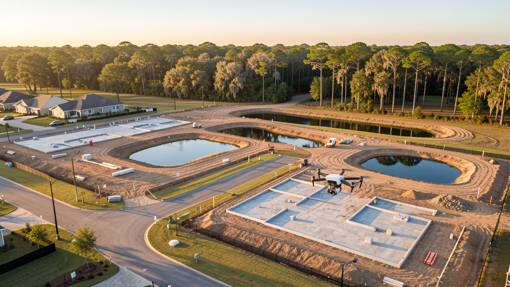
Drone Surveys for Cypress's Construction Market
Cypress is one of the fastest-growing residential areas in the Houston metro, driven by massive master-planned communities along the US 290 corridor. Bridgeland (Howard Hughes Corporation, 11,400 acres at full build-out) is one of the largest MPCs in the United States, with continuous residential, commercial, and amenity construction. Towne Lake (Johnson Development Corp., 300-acre private lake) and Cypress Creek (multiple builders) add sustained residential demand. The US 290 freeway widening project, completed in 2024, has accelerated development by improving commute times to downtown Houston and the Energy Corridor. The Grand Parkway (TX-99) segment through Cypress has opened new development corridors along its route. Commercial development along Fry Road, Skinner Road, and Fairfield Town Center is expanding to serve the growing residential base. The Cy-Fair ISD school construction program adds institutional building demand, with new schools and facility expansions needed annually.
Active Developers in the Area:
Typical Project Costs in Texas
Cost ranges are based on market data for Houston-The Woodlands-Sugar Land. Actual pricing depends on site size, complexity, and deliverables.
| Service Type | Low End | High End |
|---|---|---|
| Topographic Survey | $1,500 | $4,500 |
| Drone Inspection | $225 | $800 |
| LiDAR Scanning | $2,500 | $8,500 |
| Environmental Monitoring | $800 | $3,500 |
| Aerial Imagery | $175 | $500 |
| Construction Monitoring | $900 | $3,000 |
| Real Estate Photography | $150 | $450 |
| Roof Inspection | $200 | $750 |
Local Airspace & Regulations in Cypress, TX
FAA Part 107 Requirements
All commercial drone operations in Texas require the pilot to hold an active FAA Part 107 Remote Pilot Certificate. Our network surveyors are verified Part 107 holders.
State Drone Laws
Texas Government Code Chapter 423 restricts drone use over critical infrastructure facilities, including oil and gas pipelines, refineries, power plants, and water treatment facilities. HB 1484 (2023) added protections for agricultural operations and expanded penalties for drone surveillance of private property. Commercial operators must hold a valid FAA Part 107 Remote Pilot Certificate. Texas does not require a separate state drone license, but operators flying near critical infrastructure must obtain authorization from the facility owner. The Texas Department of Public Safety maintains additional guidelines for drone operations near state facilities.
Local Ordinances
Cypress is an unincorporated community governed by Harris County rather than a city government, so there is no separate city-level drone permit. Harris County does not issue drone-specific permits for commercial operators. FAA Part 107 certification and LAANC authorization for Class B (IAH) and Class D (DWH) airspace are the primary requirements. Commercial use of Harris County parks requires a special use permit from the Harris County Parks Department. Flights from private property (with owner permission) do not require a county permit but must comply with all FAA Part 107 rules and Texas Government Code Chapter 423 critical infrastructure restrictions. Drone flights over the Addicks Reservoir and Barker Reservoir flood control structures are prohibited without authorization from the US Army Corps of Engineers.
Restricted Airspace
- Class B airspace around George Bush Intercontinental (IAH) — the southwestern shelf of IAH Class B extends into the northeast corner of Cypress, approximately 12-15 miles from the airport. LAANC authorization is required for commercial drone flights in the area north of FM 529 and east of Highway 6. Most of Cypress proper falls outside the Class B surface area but within the outer shelves.
- Class D airspace around David Wayne Hooks Memorial Airport (DWH) — located just 8 miles north in Tomball. The southern edge of the DWH Class D zone extends into northern Cypress. Drone flights within 4 nautical miles of DWH require LAANC authorization. This is particularly relevant for survey work in the Bridgeland and Cypress Creek MPC areas along Fry Road and Mueschke Road.
- Cypress Creek and flood control infrastructure — Harris County Flood Control District maintains extensive drainage infrastructure throughout Cypress. The Addicks Reservoir watershed and multiple detention basins are critical infrastructure. Post-flood survey work requires coordination with Harris County Office of Emergency Management.
- Bridgeland MPC active construction zones — one of the largest master-planned communities in the US (11,400 acres at full build-out) with continuous active construction. Crane operations, heavy equipment, and blasting activity require drone pilots to coordinate with site superintendents. FAA Part 107 requires yielding right-of-way to all manned aircraft, including construction helicopters.
- Towne Lake MPC — large residential development with a 300-acre private lake. Drone flights over the lake during peak recreational times (weekends, holidays) risk interfering with water sports. FAA Part 107 prohibits flights over moving vehicles and vessels not under the operator's control. Recommend weekday morning flights for lake-adjacent survey work.
- Hurricane and tropical weather: Cypress sits in a high-risk flood zone, having experienced catastrophic flooding during Hurricane Harvey in 2017 and multiple subsequent storm events. Drone operations during tropical storm warnings are restricted. Post-storm damage assessment flights require coordination with Harris County Office of Emergency Management. Summer thunderstorms and Gulf Coast humidity affect flight windows — morning flights are strongly preferred May through September.
Airports in the area: undefined (undefined), undefined (undefined), undefined (undefined), undefined (undefined)
Why Hire Through Aerius View in Cypress, TX?
FAA-Certified
Every surveyor holds an active Part 107 Remote Pilot Certificate.
Local to Cypress
Surveyors who know the Texas airspace and local permitting.
No Cost to Quote
Submit your project at no charge. Pay the surveyor directly if you proceed.
Fast Turnaround
A local surveyor contacts you within 2 business days.
How Our Cypress Matching Process Works
We're actively building our network of FAA-certified drone operators in Cypress, TX. Here's exactly what happens when you submit a project request.
Submit Your Project
Tell us your site location, acreage, and what you need (topographic survey, LiDAR, inspection, etc.). Takes 60 seconds. No cost, no obligation.
We Match & Vet
We identify Part 107-certified operators in Texas with the right equipment for your project. Every pilot is verified for active certification, insurance, and relevant experience in Texas airspace.
You Get Quotes
Matched surveyors contact you within 2 business days with quotes. You compare pricing, timelines, and deliverables, then choose the right fit. You pay the surveyor directly, no markup.
What Deliverables Do You Get?
Every project includes professional-grade deliverables compatible with standard construction and engineering software:
- Orthomosaic maps (GeoTIFF) for site overview and documentation
- Point clouds (LAS/LAZ) for 3D modeling and volumetric analysis
- DEM/DSM terrain models for cut/fill and grade analysis
- Contour lines (DXF/DWG, CAD-ready) for Civil 3D and Revit
- Progress reports with side-by-side comparisons for construction monitoring
- Coordinate systems matched to your project datum (State Plane, UTM, or local)
Insurance & Liability Protection
Pilot Insurance Required
Every operator in our network must carry active liability insurance. Minimum coverage: $1,000,000 general liability. Proof of insurance is verified before any pilot joins the network.
FAA Part 107 Verified
We confirm each pilot's Remote Pilot Certificate is active and in good standing through the FAA Airmen Inquiry system. Expired certificates are flagged automatically.
Equipment Documentation
Pilots list their drone models, sensors (RGB, LiDAR, thermal, multispectral), and payload specs so we can match the right equipment to your project requirements.
Site Safety Coordination
Pilots coordinate with your site superintendent for safe operations on active construction sites, including flight plans that avoid worker areas and equipment zones.
Cypress, TX Drone Survey FAQs
Do I need a permit for a drone survey in Cypress?
Cypress is unincorporated and governed by Harris County, which does not issue a separate drone permit for commercial operators. FAA Part 107 certification is mandatory. LAANC authorization is required for flights in northern Cypress within the DWH Class D zone or in northeast Cypress within the IAH Class B shelves. Most of central Cypress falls outside controlled airspace, making LAANC unnecessary for many residential survey jobs. Flights from private property with owner permission do not require a county permit.
How much does a drone survey cost in Cypress?
Cypress pricing is competitive with the broader Houston metro. Topographic surveys typically range from $1,500 to $4,500 for residential lots and small commercial sites. LiDAR scanning runs $2,500 to $8,500 for larger MPC parcels. Roof inspections cost $200 to $750 per building. Construction monitoring is typically $900 to $3,000 per month for recurring flights at master-planned community sites like Bridgeland and Towne Lake.
Can I fly a drone near Hooks Memorial Airport?
David Wayne Hooks Memorial Airport (DWH) is located just 8 miles north of Cypress in Tomball and has Class D airspace. Drone flights within 4 nautical miles of DWH require LAANC authorization. This affects survey work in northern Cypress, particularly the Bridgeland and Cypress Creek areas along Fry Road and Mueschke Road. Always check FAA UAS Facility Maps for the exact boundary and altitude shelves.
How does Hurricane Harvey history affect drone survey work in Cypress?
Cypress experienced catastrophic flooding during Hurricane Harvey in 2017, and the area remains in a high-risk flood zone. Post-storm damage assessment flights require coordination with Harris County Office of Emergency Management. The Addicks Reservoir watershed and multiple Harris County Flood Control District detention basins are critical infrastructure. Survey work in flood-prone areas should account for elevation data accuracy, as flood plain mapping depends on precise topographic data. Our surveyors use RTK GPS and ground control points to achieve centimeter-level accuracy for flood plain certification surveys.
What are the challenges of surveying in Bridgeland and other large MPC sites?
Bridgeland is one of the largest master-planned communities in the US at 11,400 acres, with continuous active construction across multiple phases. Survey challenges include coordinating with multiple site superintendents and builders, avoiding crane swing radius, maintaining safe distance from blasting operations, and scheduling flights around heavy equipment activity. The scale of the development means topographic surveys often cover hundreds of acres per phase, requiring efficient flight planning and battery management for multi-flight missions.
What makes Cypress unique for drone survey work?
Cypress combines massive residential construction volume with relatively simple airspace for most of the area. The US 290 corridor and Grand Parkway expansion have unlocked thousands of acres for development. The flat Gulf Coast terrain makes photogrammetry efficient, but the flood-prone nature of the area means accurate topographic data is critical for drainage design and FEMA flood plain mapping. The scale of master-planned communities like Bridgeland (11,400 acres) creates ongoing multi-year survey contracts that are rare in more mature markets.
Nearby Cities
Are You a Drone Surveyor in Cypress?
Get pre-qualified leads in your service area. No membership fees, no monthly minimums. First lead free.
Ready to Start Your Project in Cypress, TX?
Get matched with a local, FAA-certified surveyor. No cost, no obligation.
Request a Free Quote