Drone Survey Services in Kennewick, WA
With 800+ new housing units permitted in 2023-2024, the Southridge Village mixed-use development, wine industry expansion, and Amazon data center spillover driving growth, Kennewick is the fastest-growing of the Tri-Cities along the Columbia River corridor.
Serving Benton County & the Tri-Cities area
Request a Free Quote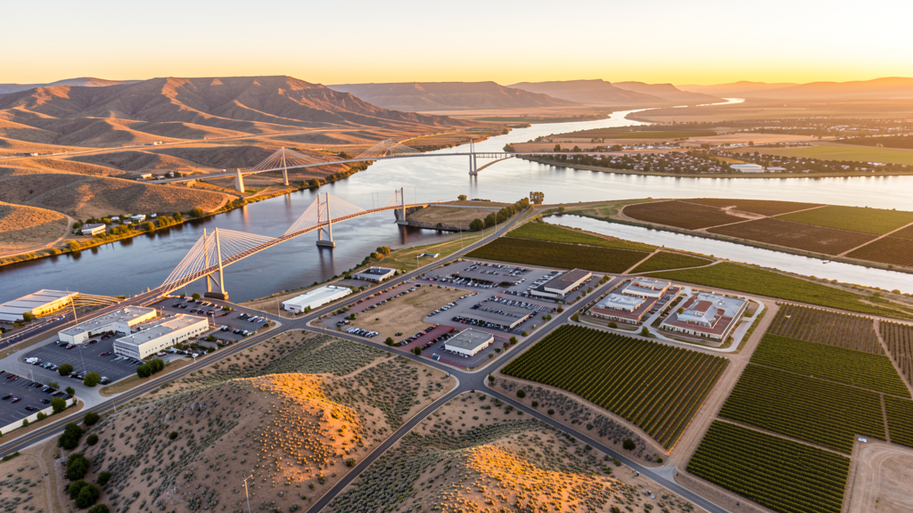
Get Matched With a Local Surveyor
Drone Survey Services Available in Kennewick, WA
Kennewick anchors the Tri-Cities region at the confluence of the Snake, Yakima, and Columbia Rivers in southeastern Washington. The city is the commercial hub for the region, driven by the expanding wine industry, the Amazon data center campus in nearby Boardman, and energy-sector employment. The Southridge area is the primary growth corridor with mixed-use development and residential subdivisions. PSC Class D airspace covers east Kennewick, while the Columbia River creates over-water survey considerations. The Hanford Nuclear Reservation to the northwest has security zones that operators should check before flying in that direction.
Drone Surveys for Kennewick's Construction Market
Kennewick is the largest of the Tri-Cities and is experiencing rapid growth driven by the wine industry expansion, the Southridge commercial development, and the Amazon data center campus in nearby Boardman. Major construction includes the Southridge Village mixed-use development, the Tri-Cities Cancer Center expansion, and residential subdivisions in the Southridge and Canyon Lakes areas. Residential permitting exceeded 800 new housing units in 2023-2024, driven by wine industry growth, tech-sector spillover from Amazon data centers, and affordable living compared to Seattle metro. The cable bridge replacement planning and Highway 397 improvements are the largest infrastructure projects.
Active Developers in the Area:

Typical Project Costs in Washington
Cost ranges are based on market data for Tri-Cities. Actual pricing depends on site size, complexity, and deliverables.
| Service Type | Low End | High End |
|---|---|---|
| Topographic Survey | $1,100 | $4,200 |
| Drone Inspection | $750 | $2,700 |
| LiDAR Scanning | $2,600 | $7,200 |
| Environmental Monitoring | $1,300 | $4,500 |
| Aerial Imagery | $420 | $1,600 |
| Construction Monitoring | $900 | $3,300 |
| Real Estate Photography | $300 | $1,100 |
| Roof Inspection | $350 | $1,200 |
Local Airspace & Regulations in Kennewick, WA
FAA Part 107 Requirements
All commercial drone operations in Washington require the pilot to hold an active FAA Part 107 Remote Pilot Certificate. Our network surveyors are verified Part 107 holders.
State Drone Laws
Washington regulates drones through multiple statutes. ESSB 6001 (2015) requires law enforcement to obtain a warrant before using drones for surveillance, with exceptions for emergency response, search and rescue, and forest fire management. RCW 9A.44.115 extends voyeurism laws to drone-based image capture of private premises. RCW 46.60.130 prohibits drone interference with manned aircraft and emergency response operations. Washington does not require a separate state-level drone license for commercial operators, but all commercial drone pilots must hold a valid FAA Part 107 Remote Pilot Certificate. The state preempts local regulation of drone flight paths and navigable airspace (RCW 47.68), though cities may regulate takeoff and landing on public property they own. Washington State Parks prohibit drone takeoff and landing without a permit (WAC 352-32). Commercial operators near military installations (JBLM, Fairchild AFB, Naval Air Station Whidbey Island) must coordinate with base operations.
Local Ordinances
Kennewick does not have a formal drone permitting ordinance, but requests 48-hour notification for commercial drone operations on city-owned property. Washington ESSB 6001 governs law enforcement drone use. Washington State Parks (WAC 352-32) prohibit drone takeoff and landing without a permit. Flights from private property require owner permission and FAA Part 107 compliance. The Hanford Nuclear Reservation 15 miles northwest has security zones that should be checked on FAA charts. PSC Class D airspace covers east Kennewick requiring LAANC authorization.
Restricted Airspace
- PSC Class D airspace extends 4 nautical miles from Tri-Cities Airport, surface to 2,500 ft AGL. East Kennewick falls within the PSC Class D requiring LAANC authorization for commercial drone flights.
- Hanford Nuclear Reservation is 15 miles northwest. While not active airspace restriction, the Hanford site has security zones and potential TFRs. Check FAA charts for any expanded restrictions before flying north toward the Hanford area.
- Columbia River creates over-water flight considerations. Drone flights over the river must maintain visual line of sight. The river corridor between Kennewick and Pasco is a major transportation and recreation area.
- Kennewick City Code requires notification for commercial drone operations on city property including Columbia Park, Southridge Sports Complex, and Keewaydin Park. No formal permit fee but 48-hour notice required.
- Agricultural lands south of Kennewick. Commercial drone flights over active farmland should coordinate with aerial applicators during crop spraying season (April through September).
Airports in the area: undefined (undefined), undefined (undefined), undefined (undefined)
Why Hire Through Aerius View in Kennewick, WA?
FAA-Certified
Every surveyor holds an active Part 107 Remote Pilot Certificate.
Local to Kennewick
Surveyors who know the Washington airspace and local permitting.
No Cost to Quote
Submit your project at no charge. Pay the surveyor directly if you proceed.
Fast Turnaround
A local surveyor contacts you within 2 business days.
How Our Kennewick Matching Process Works
We're actively building our network of FAA-certified drone operators in Kennewick, WA. Here's exactly what happens when you submit a project request.
Submit Your Project
Tell us your site location, acreage, and what you need (topographic survey, LiDAR, inspection, etc.). Takes 60 seconds. No cost, no obligation.
We Match & Vet
We identify Part 107-certified operators in Washington with the right equipment for your project. Every pilot is verified for active certification, insurance, and relevant experience in Washington airspace.
You Get Quotes
Matched surveyors contact you within 2 business days with quotes. You compare pricing, timelines, and deliverables, then choose the right fit. You pay the surveyor directly, no markup.
What Deliverables Do You Get?
Every project includes professional-grade deliverables compatible with standard construction and engineering software:
- Orthomosaic maps (GeoTIFF) for site overview and documentation
- Point clouds (LAS/LAZ) for 3D modeling and volumetric analysis
- DEM/DSM terrain models for cut/fill and grade analysis
- Contour lines (DXF/DWG, CAD-ready) for Civil 3D and Revit
- Progress reports with side-by-side comparisons for construction monitoring
- Coordinate systems matched to your project datum (State Plane, UTM, or local)
Insurance & Liability Protection
Pilot Insurance Required
Every operator in our network must carry active liability insurance. Minimum coverage: $1,000,000 general liability. Proof of insurance is verified before any pilot joins the network.
FAA Part 107 Verified
We confirm each pilot's Remote Pilot Certificate is active and in good standing through the FAA Airmen Inquiry system. Expired certificates are flagged automatically.
Equipment Documentation
Pilots list their drone models, sensors (RGB, LiDAR, thermal, multispectral), and payload specs so we can match the right equipment to your project requirements.
Site Safety Coordination
Pilots coordinate with your site superintendent for safe operations on active construction sites, including flight plans that avoid worker areas and equipment zones.
Kennewick, WA Drone Survey FAQs
Do I need LAANC authorization to fly a drone in Kennewick?
East Kennewick falls within the PSC Class D airspace requiring LAANC authorization. West Kennewick is primarily in uncontrolled Class G airspace. Check the FAA UAS Facility Map for your specific flight location.
What is driving the construction boom in Kennewick?
The Southridge Village mixed-use development, wine industry expansion, Amazon data center spillover, and 800+ new housing units permitted in 2023-2024 are driving demand. The cable bridge replacement planning and Highway 397 improvements are the largest infrastructure projects.
Are there airspace restrictions near the Hanford Nuclear Reservation?
The Hanford Nuclear Reservation is 15 miles northwest. While not an active airspace restriction for most of Kennewick, the Hanford site has security zones and potential TFRs. Check FAA charts for any expanded restrictions before flying north toward the Hanford area.
Can I fly a drone over the Columbia River?
FAA regulations require maintaining visual line of sight. Do not fly beyond visual range over water. The Columbia River corridor between Kennewick and Pasco is heavily used for recreation and transportation. Coordinate with river traffic before flying near the bridges.
How much does a drone survey cost in Kennewick?
Topographic surveys in Kennewick range from $1,100 to $4,200. LiDAR scanning costs $2,600 to $7,200. Construction monitoring runs $900 to $3,300. Pricing reflects the Tri-Cities market, which is moderate compared to Seattle metro but strong due to energy and wine industry growth.
Nearby Cities
Are You a Drone Surveyor in Kennewick?
Get pre-qualified leads in your service area. No membership fees, no monthly minimums. First lead free.
Ready to Start Your Project in Kennewick, WA?
Get matched with a local, FAA-certified surveyor. No cost, no obligation.
Request a Free Quote