Drone Survey Services in Kingman, AZ
From I-40 logistics warehouses and Kingman Airport Industrial Park to Cerbat Foothills residential growth and renewable energy projects, Kingman is a growing Route 66 city where BLM lands and Hualapai tribal boundaries shape every survey mission.
Serving Mohave County & the Kingman area
Request a Free Quote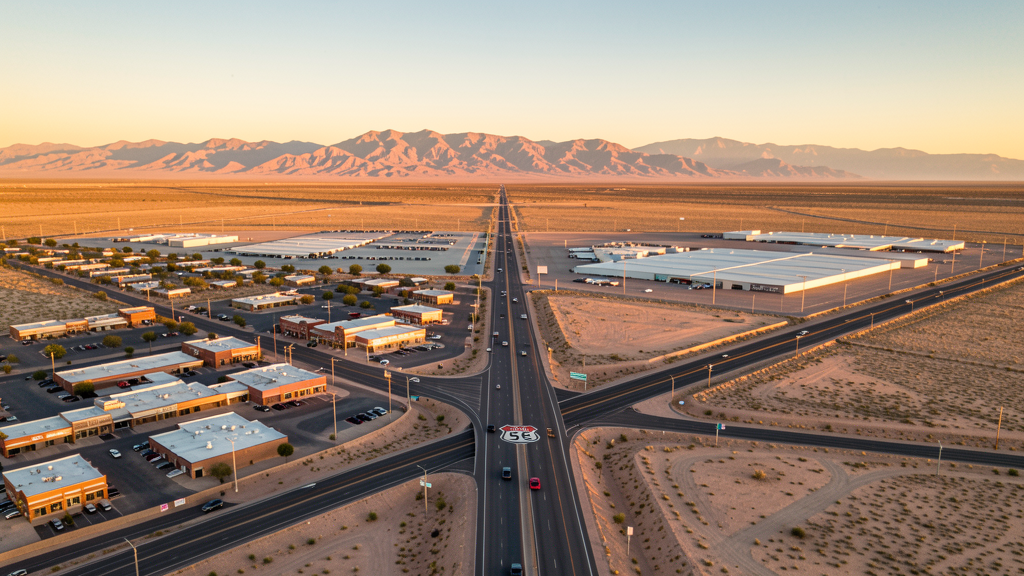
Get Matched With a Local Surveyor
Drone Survey Services Available in Kingman, AZ
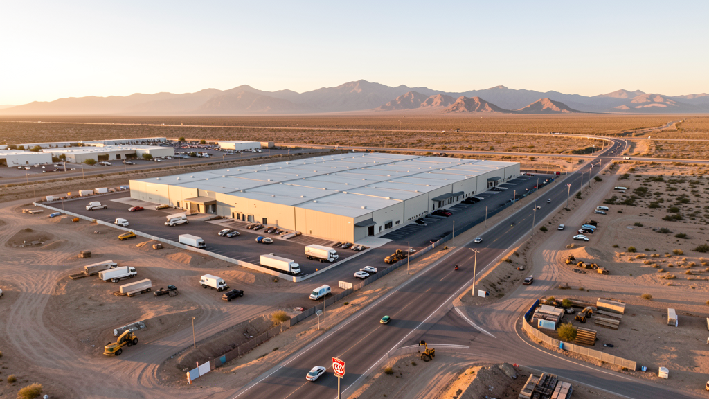
Kingman is driven by transportation logistics, residential growth, and renewable energy. The I-40 corridor and Airport Industrial Park attract distribution tenants. Renewable energy projects in Mohave County require aerial survey. BLM lands and Hualapai tribal lands create operational boundaries.
Drone Surveys for Kingman's Construction Market
Kingman is a growing desert city along historic Route 66 with a construction market driven by transportation logistics, residential growth, and renewable energy. The city has become a regional distribution hub, with warehouse and logistics development along the I-40 corridor. The Kingman Airport Industrial Park is attracting manufacturing and distribution tenants. Residential growth in the Cerbat Foothills area and along Stockton Hill Road generates demand for topographic surveys. Renewable energy projects, including wind and solar developments in the surrounding Mohave County, require aerial survey and monitoring. The city has invested in water infrastructure and downtown Route 66 revitalization.
Active Developers in the Area:
Typical Project Costs in Arizona
Cost ranges are based on market data for Kingman. Actual pricing depends on site size, complexity, and deliverables.
| Service Type | Low End | High End |
|---|---|---|
| Topographic Survey | $1,800 | $4,500 |
| Drone Inspection | $250 | $850 |
| LiDAR Scanning | $2,800 | $8,500 |
| Environmental Monitoring | $800 | $3,200 |
| Aerial Imagery | $175 | $500 |
| Construction Monitoring | $1,200 | $3,200 |
| Real Estate Photography | $175 | $450 |
| Roof Inspection | $225 | $800 |
Local Airspace & Regulations in Kingman, AZ
FAA Part 107 Requirements
All commercial drone operations in Arizona require the pilot to hold an active FAA Part 107 Remote Pilot Certificate. Our network surveyors are verified Part 107 holders.
State Drone Laws
Arizona SB 1449 (2016) was the first state law regulating drone use, prohibiting drone operations that interfere with law enforcement, emergency responders, or wildfire suppression efforts. The law prohibits drone flights within 3 miles of a wildfire or prescribed burn and makes violation a class 1 misdemeanor. ARS Title 13 Chapter 29 Article 3 restricts drone surveillance of private property and weaponization of drones. Commercial operators must hold a valid FAA Part 107 Remote Pilot Certificate. Arizona does not require a separate state drone license, but operators must comply with FAA Part 107 rules and any local ordinances. The Arizona Department of Public Safety maintains guidelines for drone operations near critical infrastructure including power plants, dams, and military installations.
Local Ordinances
Kingman follows Mohave County regulations for drone operations. Commercial operators must hold FAA Part 107 certification. The city does not have a specific drone ordinance but requires a special event permit for drone demonstrations at public events like the Route 66 Festival. Flights over Hualapai Indian Reservation lands require tribal government permission. The city has historically addressed drone complaints through nuisance ordinances. BLM land surrounding Kingman generally allows drone operations but operators should verify any special use area restrictions.
Restricted Airspace
- Kingman Airport (IGM) is uncontrolled but has general aviation traffic. Drone operators should monitor CTAF 122.8 and maintain visual line of sight. The airport has historical significance as a WWII pilot training field.
- Hualapai Indian Reservation lands south and east of Kingman. Drone flights over tribal land require permission from the tribal government.
- Mohave County has extensive BLM (Bureau of Land Management) lands. While BLM land generally allows drone operations, operators should verify any special use area restrictions.
- Route 66 corridor through Kingman has heavy tourist traffic. Drone flights over the historic downtown Route 66 area should be coordinated with the city during events.
- Remote desert areas around Kingman have limited cell coverage. Pre-programmed waypoint missions are recommended for survey flights outside town limits.
Airports in the area: undefined (undefined), undefined (undefined), undefined (undefined)
Why Hire Through Aerius View in Kingman, AZ?
FAA-Certified
Every surveyor holds an active Part 107 Remote Pilot Certificate.
Local to Kingman
Surveyors who know the Arizona airspace and local permitting.
No Cost to Quote
Submit your project at no charge. Pay the surveyor directly if you proceed.
Fast Turnaround
A local surveyor contacts you within 2 business days.
How Our Kingman Matching Process Works
We're actively building our network of FAA-certified drone operators in Kingman, AZ. Here's exactly what happens when you submit a project request.
Submit Your Project
Tell us your site location, acreage, and what you need (topographic survey, LiDAR, inspection, etc.). Takes 60 seconds. No cost, no obligation.
We Match & Vet
We identify Part 107-certified operators in Arizona with the right equipment for your project. Every pilot is verified for active certification, insurance, and relevant experience in Arizona airspace.
You Get Quotes
Matched surveyors contact you within 2 business days with quotes. You compare pricing, timelines, and deliverables, then choose the right fit. You pay the surveyor directly, no markup.
What Deliverables Do You Get?
Every project includes professional-grade deliverables compatible with standard construction and engineering software:
- Orthomosaic maps (GeoTIFF) for site overview and documentation
- Point clouds (LAS/LAZ) for 3D modeling and volumetric analysis
- DEM/DSM terrain models for cut/fill and grade analysis
- Contour lines (DXF/DWG, CAD-ready) for Civil 3D and Revit
- Progress reports with side-by-side comparisons for construction monitoring
- Coordinate systems matched to your project datum (State Plane, UTM, or local)
Insurance & Liability Protection
Pilot Insurance Required
Every operator in our network must carry active liability insurance. Minimum coverage: $1,000,000 general liability. Proof of insurance is verified before any pilot joins the network.
FAA Part 107 Verified
We confirm each pilot's Remote Pilot Certificate is active and in good standing through the FAA Airmen Inquiry system. Expired certificates are flagged automatically.
Equipment Documentation
Pilots list their drone models, sensors (RGB, LiDAR, thermal, multispectral), and payload specs so we can match the right equipment to your project requirements.
Site Safety Coordination
Pilots coordinate with your site superintendent for safe operations on active construction sites, including flight plans that avoid worker areas and equipment zones.
Kingman, AZ Drone Survey FAQs
Do I need a permit for a drone survey in Kingman?
Kingman follows Mohave County regulations. You need a permit only for flights on public property. Surveys from private property with owner permission do not require a city permit. All commercial operations require FAA Part 107 certification.
Can I fly drones over BLM land near Kingman?
BLM land generally allows drone operations, but operators should verify any special use area restrictions. Mohave County has extensive BLM lands. Commercial drone operators should check with the BLM Kingman Field Office for any area-specific restrictions before flying.
What are the main construction survey needs in Kingman?
Warehouse and logistics development along I-40, the Kingman Airport Industrial Park, residential growth in Cerbat Foothills, and renewable energy projects in Mohave County are the main drivers. Water infrastructure and Route 66 revitalization also generate survey demand.
Are there tribal land restrictions near Kingman?
The Hualapai Indian Reservation is south and east of Kingman. Drone flights over tribal land require permission from the Hualapai tribal government. Always verify reservation boundaries before flying. Unauthorized flights over tribal land may be treated as trespassing.
How much does a drone survey cost in Kingman?
Topographic surveys range from $1,800 to $4,500. Roof inspections run $225-$800. LiDAR scanning for larger desert sites can cost $2,800-$8,500. Real estate drone photography starts at $175. Logistics and industrial park survey work may have volume pricing.
Nearby Cities
Are You a Drone Surveyor in Kingman?
Get pre-qualified leads in your service area. No membership fees, no monthly minimums. First lead free.
Ready to Start Your Project in Kingman, AZ?
Get matched with a local, FAA-certified surveyor. No cost, no obligation.
Request a Free Quote