Drone Survey Services in Lake Havasu City, AZ
From second-home development and resort renovations to water infrastructure and solar projects, Lake Havasu City is a resort community where 115-degree summer heat and Colorado River recreation zones shape every survey mission.
Serving Mohave County & the Lake Havasu City area
Request a Free Quote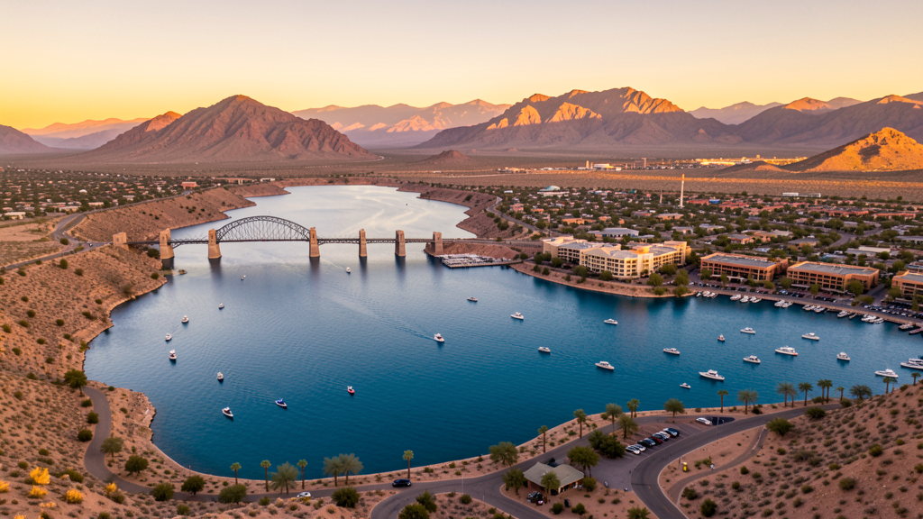
Get Matched With a Local Surveyor
Drone Survey Services Available in Lake Havasu City, AZ
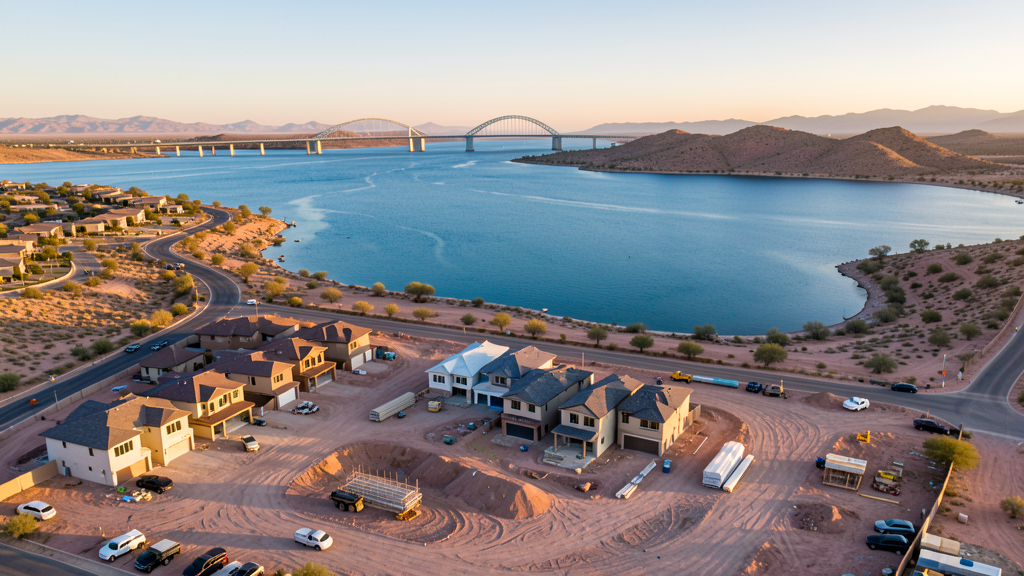
Lake Havasu City is a resort and retirement community driven by second-home development, resort renovations, and retail expansion. The city has invested in water infrastructure improvements. Extreme summer heat exceeding 115 degrees creates operational challenges. The London Bridge area and Lake Havasu National Wildlife Refuge have drone restrictions.
Drone Surveys for Lake Havasu City's Construction Market
Lake Havasu City is a resort and retirement community with construction driven by second-home development, resort renovations, and retail expansion. The city has seen sustained residential growth in the north area near the airport and in the Island subdivision. Commercial development along McCulloch Boulevard and the retail corridor continues to expand. The city has invested in water infrastructure and wastewater treatment improvements. Tourism infrastructure including hotel renovations and restaurant construction generates periodic demand for survey services. The nearby Parker strip area also has ongoing residential development. Solar energy projects in the surrounding desert are an emerging market for aerial survey.
Active Developers in the Area:
Typical Project Costs in Arizona
Cost ranges are based on market data for Lake Havasu City. Actual pricing depends on site size, complexity, and deliverables.
| Service Type | Low End | High End |
|---|---|---|
| Topographic Survey | $1,800 | $4,500 |
| Drone Inspection | $250 | $850 |
| LiDAR Scanning | $2,800 | $8,500 |
| Environmental Monitoring | $800 | $3,200 |
| Aerial Imagery | $175 | $500 |
| Construction Monitoring | $1,200 | $3,200 |
| Real Estate Photography | $175 | $450 |
| Roof Inspection | $225 | $800 |
Local Airspace & Regulations in Lake Havasu City, AZ
FAA Part 107 Requirements
All commercial drone operations in Arizona require the pilot to hold an active FAA Part 107 Remote Pilot Certificate. Our network surveyors are verified Part 107 holders.
State Drone Laws
Arizona SB 1449 (2016) was the first state law regulating drone use, prohibiting drone operations that interfere with law enforcement, emergency responders, or wildfire suppression efforts. The law prohibits drone flights within 3 miles of a wildfire or prescribed burn and makes violation a class 1 misdemeanor. ARS Title 13 Chapter 29 Article 3 restricts drone surveillance of private property and weaponization of drones. Commercial operators must hold a valid FAA Part 107 Remote Pilot Certificate. Arizona does not require a separate state drone license, but operators must comply with FAA Part 107 rules and any local ordinances. The Arizona Department of Public Safety maintains guidelines for drone operations near critical infrastructure including power plants, dams, and military installations.
Local Ordinances
Lake Havasu City requires a commercial drone permit for operations taking off or landing on city-owned property, including parks and the London Bridge area. The city has received numerous complaints about drones flying over beaches and boating areas, leading to heightened enforcement. Commercial operators must hold FAA Part 107 certification. Flights over Lake Havasu State Park and Lake Havasu National Wildlife Refuge are restricted. The city prohibits drone flights over large public gatherings at the London Bridge Beach and Rotary Park during events without specific authorization. Summer heat creates operational challenges that require careful planning.
Restricted Airspace
- Class D airspace around Lake Havasu City Airport (HII) — extends 4 nautical miles. LAANC authorization required for commercial drone flights within this zone.
- Lake Havasu itself is a popular recreation area with heavy boat and personal watercraft traffic. Drone flights over the lake should maintain safe distances from boaters and swimmers. The London Bridge area is a high-traffic tourist zone.
- Chemehuevi Indian Reservation lands on the California side of the Colorado River. Drone flights over tribal land require permission from the tribal government.
- Lake Havasu National Wildlife Refuge areas along the Colorado River — US Fish and Wildlife Service restricts drone operations near wildlife habitat, especially during bird nesting season.
- High summer temperatures: Lake Havasu City regularly exceeds 115 degrees in summer. Drone battery thermal shutdowns are a significant risk. Early morning flights before 8 AM are essential June through September.
Airports in the area: undefined (undefined), undefined (undefined), undefined (undefined)
Why Hire Through Aerius View in Lake Havasu City, AZ?
FAA-Certified
Every surveyor holds an active Part 107 Remote Pilot Certificate.
Local to Lake Havasu City
Surveyors who know the Arizona airspace and local permitting.
No Cost to Quote
Submit your project at no charge. Pay the surveyor directly if you proceed.
Fast Turnaround
A local surveyor contacts you within 2 business days.
How Our Lake Havasu City Matching Process Works
We're actively building our network of FAA-certified drone operators in Lake Havasu City, AZ. Here's exactly what happens when you submit a project request.
Submit Your Project
Tell us your site location, acreage, and what you need (topographic survey, LiDAR, inspection, etc.). Takes 60 seconds. No cost, no obligation.
We Match & Vet
We identify Part 107-certified operators in Arizona with the right equipment for your project. Every pilot is verified for active certification, insurance, and relevant experience in Arizona airspace.
You Get Quotes
Matched surveyors contact you within 2 business days with quotes. You compare pricing, timelines, and deliverables, then choose the right fit. You pay the surveyor directly, no markup.
What Deliverables Do You Get?
Every project includes professional-grade deliverables compatible with standard construction and engineering software:
- Orthomosaic maps (GeoTIFF) for site overview and documentation
- Point clouds (LAS/LAZ) for 3D modeling and volumetric analysis
- DEM/DSM terrain models for cut/fill and grade analysis
- Contour lines (DXF/DWG, CAD-ready) for Civil 3D and Revit
- Progress reports with side-by-side comparisons for construction monitoring
- Coordinate systems matched to your project datum (State Plane, UTM, or local)
Insurance & Liability Protection
Pilot Insurance Required
Every operator in our network must carry active liability insurance. Minimum coverage: $1,000,000 general liability. Proof of insurance is verified before any pilot joins the network.
FAA Part 107 Verified
We confirm each pilot's Remote Pilot Certificate is active and in good standing through the FAA Airmen Inquiry system. Expired certificates are flagged automatically.
Equipment Documentation
Pilots list their drone models, sensors (RGB, LiDAR, thermal, multispectral), and payload specs so we can match the right equipment to your project requirements.
Site Safety Coordination
Pilots coordinate with your site superintendent for safe operations on active construction sites, including flight plans that avoid worker areas and equipment zones.
Lake Havasu City, AZ Drone Survey FAQs
Do I need a permit for a drone survey in Lake Havasu City?
You need a commercial drone permit for flights taking off or landing on city property, including parks and the London Bridge area. Surveys from private property with owner permission do not require a city permit. All commercial operations require FAA Part 107 certification.
Can I fly drones over Lake Havasu?
Drone flights over the lake should maintain safe distances from boaters and swimmers. The London Bridge area is a high-traffic tourist zone with heightened enforcement. Lake Havasu State Park restricts drone takeoff and landing. Lake Havasu National Wildlife Refuge areas have additional restrictions, especially during bird nesting season.
How does the extreme heat affect drone operations in Lake Havasu City?
Lake Havasu City regularly exceeds 115 degrees in summer, making it one of the hottest cities in the US. Drone battery thermal shutdowns are a significant risk. Early morning flights before 8 AM are essential June through September. Our local surveyors schedule flights to avoid peak heat and monitor battery temperatures closely.
Are there tribal land restrictions near Lake Havasu City?
The Chemehuevi Indian Reservation on the California side of the Colorado River requires permission from the tribal government for drone overflights. Always verify reservation boundaries before flying near the river. Unauthorized flights over tribal land may be treated as trespassing.
How much does a drone survey cost in Lake Havasu City?
Topographic surveys range from $1,800 to $4,500. Roof inspections run $225-$800. Real estate drone photography starts at $175. LiDAR scanning for larger desert sites can cost $2,800-$8,500. Resort and second-home aerial photography is a significant market.
Nearby Cities
Are You a Drone Surveyor in Lake Havasu City?
Get pre-qualified leads in your service area. No membership fees, no monthly minimums. First lead free.
Ready to Start Your Project in Lake Havasu City, AZ?
Get matched with a local, FAA-certified surveyor. No cost, no obligation.
Request a Free Quote