Drone Survey Services in Sedona, AZ
From luxury home construction in the red rocks to resort renovations and Highway 179 improvements, Sedona is a high-value construction market at 4,350 feet where wilderness boundaries, helicopter tour traffic, and strict regulations shape every survey mission.
Serving Coconino County & the Sedona area
Request a Free Quote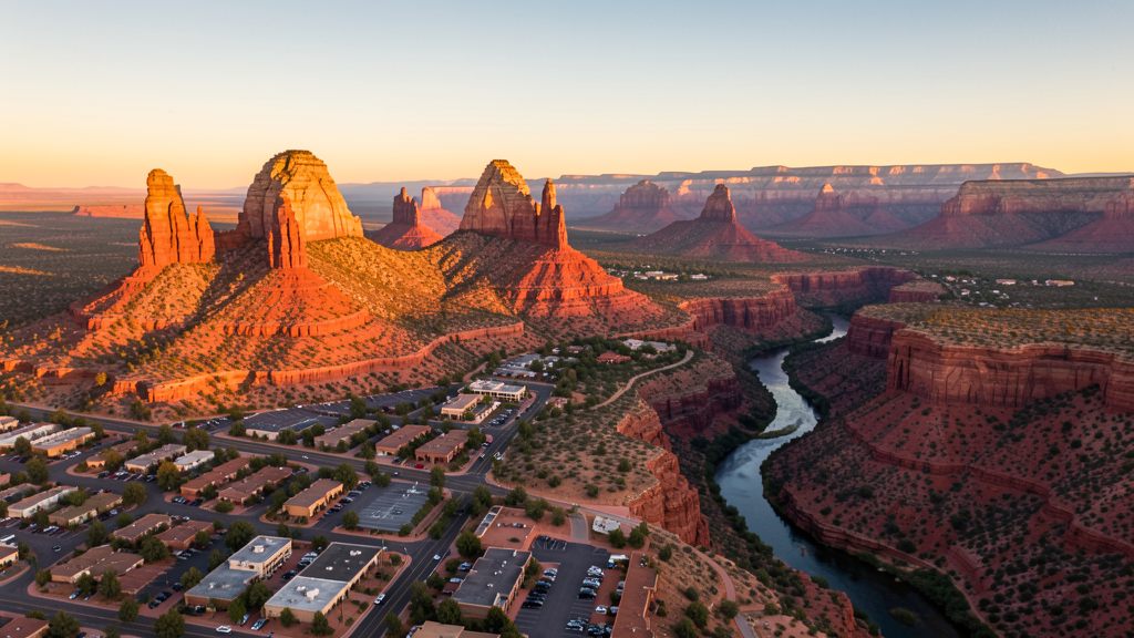
Get Matched With a Local Surveyor
Drone Survey Services Available in Sedona, AZ
Sedona is a small but high-value market focused on luxury residential, resort, and tourism infrastructure. Strict building codes and design review require detailed surveys. The limited flat land and steep red rock terrain make drone surveys particularly valuable. Wilderness areas and helicopter traffic create unique airspace challenges.
Drone Surveys for Sedona's Construction Market
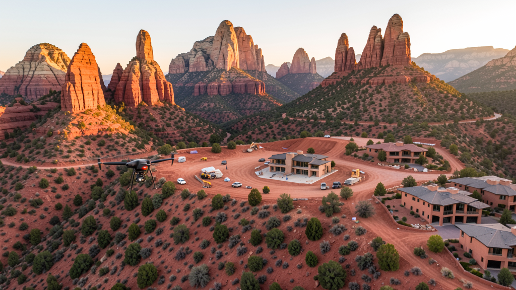
Sedona is a small but high-value construction market focused on luxury residential, resort, and tourism infrastructure. The city has seen ongoing development of high-end homes in the Canyon and Chapel area, resort renovations, and Uptown commercial improvements. The city strict building codes and design review process require detailed topographic surveys for any new construction. Road improvements along Highway 179 and the Uptown traffic management project generate infrastructure survey needs. The limited flat land and steep terrain make drone surveys particularly valuable compared to traditional ground survey methods.
Active Developers in the Area:
Typical Project Costs in Arizona
Cost ranges are based on market data for Sedona. Actual pricing depends on site size, complexity, and deliverables.
| Service Type | Low End | High End |
|---|---|---|
| Topographic Survey | $2,500 | $6,000 |
| Drone Inspection | $300 | $1,000 |
| LiDAR Scanning | $3,500 | $10,000 |
| Environmental Monitoring | $1,000 | $4,000 |
| Aerial Imagery | $250 | $700 |
| Construction Monitoring | $1,500 | $4,000 |
| Real Estate Photography | $250 | $650 |
| Roof Inspection | $300 | $950 |
Local Airspace & Regulations in Sedona, AZ
FAA Part 107 Requirements
All commercial drone operations in Arizona require the pilot to hold an active FAA Part 107 Remote Pilot Certificate. Our network surveyors are verified Part 107 holders.
State Drone Laws
Arizona SB 1449 (2016) was the first state law regulating drone use, prohibiting drone operations that interfere with law enforcement, emergency responders, or wildfire suppression efforts. The law prohibits drone flights within 3 miles of a wildfire or prescribed burn and makes violation a class 1 misdemeanor. ARS Title 13 Chapter 29 Article 3 restricts drone surveillance of private property and weaponization of drones. Commercial operators must hold a valid FAA Part 107 Remote Pilot Certificate. Arizona does not require a separate state drone license, but operators must comply with FAA Part 107 rules and any local ordinances. The Arizona Department of Public Safety maintains guidelines for drone operations near critical infrastructure including power plants, dams, and military installations.
Local Ordinances
Sedona has strict regulations on commercial drone operations due to its tourism and natural beauty focus. The city requires a permit for commercial drone photography and videography taking off or landing on city property. Sedona parks and trailheads, including Slide Rock State Park and Red Rock State Park, prohibit drone takeoff and landing. The city has historically received numerous complaints about drones disturbing the natural experience, leading to heightened enforcement. Commercial operators must coordinate with the Sedona Parks and Recreation Department. Flights over the Uptown shopping district and tourist areas during peak hours are discouraged. The Sedona Airport, situated on a mesa, has its own operational guidelines for drone activities.
Restricted Airspace
- Sedona Airport (SED) sits on a 4,830 ft mesa top. While uncontrolled, the airport has unique terrain challenges. Drone operators must monitor CTAF 122.9 and be aware of helicopter tour traffic and emergency medical flights.
- Red Rock Secret Mountain Wilderness and Sycamore Canyon Wilderness areas surround Sedona. Drone flights are prohibited in all designated wilderness areas by the US Forest Service.
- Coconino National Forest and Prescott National Forest both border Sedona. Designated wilderness areas within both forests prohibit drone operations.
- Heavy helicopter tour traffic from Sedona Airport creates additional airspace complexity. Drone operators should maintain visual line of sight and monitor for low-flying helicopters, especially near Cathedral Rock, Bell Rock, and Airport Mesa.
- High-altitude operations: Sedona sits at 4,350 ft elevation. Drone performance is moderately reduced. Mountain thermals and turbulence are common, especially in the afternoon.
Airports in the area: undefined (undefined), undefined (undefined), undefined (undefined)
Why Hire Through Aerius View in Sedona, AZ?
FAA-Certified
Every surveyor holds an active Part 107 Remote Pilot Certificate.
Local to Sedona
Surveyors who know the Arizona airspace and local permitting.
No Cost to Quote
Submit your project at no charge. Pay the surveyor directly if you proceed.
Fast Turnaround
A local surveyor contacts you within 2 business days.
How Our Sedona Matching Process Works
We're actively building our network of FAA-certified drone operators in Sedona, AZ. Here's exactly what happens when you submit a project request.
Submit Your Project
Tell us your site location, acreage, and what you need (topographic survey, LiDAR, inspection, etc.). Takes 60 seconds. No cost, no obligation.
We Match & Vet
We identify Part 107-certified operators in Arizona with the right equipment for your project. Every pilot is verified for active certification, insurance, and relevant experience in Arizona airspace.
You Get Quotes
Matched surveyors contact you within 2 business days with quotes. You compare pricing, timelines, and deliverables, then choose the right fit. You pay the surveyor directly, no markup.
What Deliverables Do You Get?
Every project includes professional-grade deliverables compatible with standard construction and engineering software:
- Orthomosaic maps (GeoTIFF) for site overview and documentation
- Point clouds (LAS/LAZ) for 3D modeling and volumetric analysis
- DEM/DSM terrain models for cut/fill and grade analysis
- Contour lines (DXF/DWG, CAD-ready) for Civil 3D and Revit
- Progress reports with side-by-side comparisons for construction monitoring
- Coordinate systems matched to your project datum (State Plane, UTM, or local)
Insurance & Liability Protection
Pilot Insurance Required
Every operator in our network must carry active liability insurance. Minimum coverage: $1,000,000 general liability. Proof of insurance is verified before any pilot joins the network.
FAA Part 107 Verified
We confirm each pilot's Remote Pilot Certificate is active and in good standing through the FAA Airmen Inquiry system. Expired certificates are flagged automatically.
Equipment Documentation
Pilots list their drone models, sensors (RGB, LiDAR, thermal, multispectral), and payload specs so we can match the right equipment to your project requirements.
Site Safety Coordination
Pilots coordinate with your site superintendent for safe operations on active construction sites, including flight plans that avoid worker areas and equipment zones.
Sedona, AZ Drone Survey FAQs
Can I fly a drone in Sedona for commercial photography?
Sedona has strict regulations for commercial drone operations. You need a permit from the Parks and Recreation Department for flights taking off or landing on city property. State parks including Slide Rock and Red Rock prohibit drone takeoff and landing. All commercial operations require FAA Part 107 certification. The city enforces these rules actively due to tourism impact concerns.
Are there wilderness area restrictions around Sedona?
Yes. Red Rock Secret Mountain Wilderness and Sycamore Canyon Wilderness surround Sedona. Drone flights are prohibited in all designated wilderness areas by the US Forest Service. Coconino and Prescott National Forests border the city. Operators must verify wilderness boundaries before any flight.
What makes Sedona challenging for drone survey work?
Sedona sits at 4,350 ft elevation with red rock terrain creating unique wind patterns and thermals. The Sedona Airport on a mesa top has heavy helicopter tour traffic. Limited flat land and steep terrain make drone surveys particularly valuable but require experienced pilots familiar with mountain flying conditions.
Can I fly drones near Slide Rock State Park?
No. Slide Rock State Park prohibits drone takeoff and landing within park boundaries under Arizona State Parks regulations. Red Rock State Park also prohibits drone operations. Plan survey routes that avoid all state park boundaries.
How much does a drone survey cost in Sedona?
Costs are higher than Phoenix or Tucson due to terrain complexity and strict regulations. Topographic surveys range from $2,500 to $6,000. LiDAR scanning for steep terrain can cost $3,500-$10,000. Real estate drone photography starts at $250. Luxury home aerial photography is a significant market in Sedona.
Do I need to worry about helicopter traffic in Sedona?
Yes. Sedona Airport on the mesa top has heavy helicopter tour traffic, especially during peak tourist season. Medical emergency flights also use the airport. Always monitor CTAF 122.9, maintain visual line of sight, and be alert for low-flying helicopters near Cathedral Rock, Bell Rock, and Airport Mesa.
Nearby Cities
Are You a Drone Surveyor in Sedona?
Get pre-qualified leads in your service area. No membership fees, no monthly minimums. First lead free.
Ready to Start Your Project in Sedona, AZ?
Get matched with a local, FAA-certified surveyor. No cost, no obligation.
Request a Free Quote