Drone Survey Services in Twin Falls, ID
Twin Falls construction market is anchored by the $60M St. Luke Magic Valley expansion, the I-84 interchange reconstruction, and agricultural processing facility upgrades from Chobani and Clif Bar, driving steady demand for industrial site and topographic drone surveys in south-central Idaho.
Serving Twin Falls County & the Twin Falls area
Request a Free Quote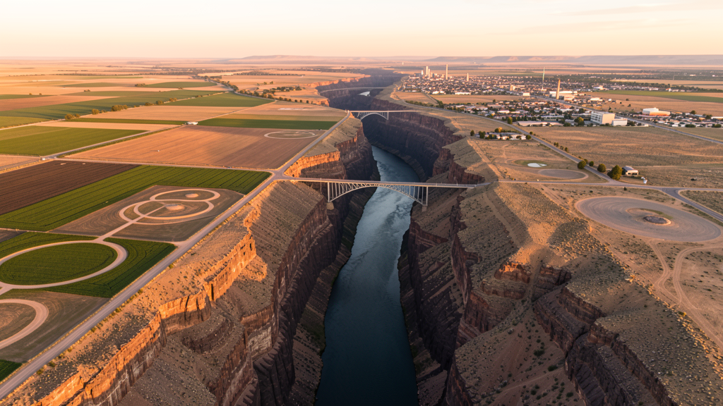
Get Matched With a Local Surveyor
Drone Survey Services Available in Twin Falls, ID
Twin Falls is the largest city in south-central Idaho and serves as the regional commercial and healthcare hub for the Magic Valley. The city economy is anchored by agricultural processing, with major facilities including Chobani and Clif Bar. The Snake River Canyon defines the southern edge of the city, creating unique survey challenges and opportunities. Agricultural drone survey demand is strong for precision agriculture, irrigation mapping, and crop health monitoring across surrounding farmland.
Drone Surveys for Twin Falls's Construction Market
Twin Falls is the regional hub for south-central Idaho, with construction driven by agricultural processing, healthcare, and retail sectors. The $60M St. Luke Magic Valley expansion and the College of Southern Idaho campus improvements are major projects. The city approved approximately $35M in building permits in 2023, including the Canyon Rim commercial development and the Pole Line Road corridor expansion. The I-84 Twin Falls interchange reconstruction ($18M ITD project) and the Blue Lakes Boulevard widening are ongoing. Agricultural processing facility expansions including Chobani yogurt plant and Clif Bar facility continue to drive industrial site survey demand.
Active Developers in the Area:

Typical Project Costs in Idaho
Cost ranges are based on market data for Twin Falls. Actual pricing depends on site size, complexity, and deliverables.
| Service Type | Low End | High End |
|---|---|---|
| Topographic Survey | $1,300 | $3,900 |
| Drone Inspection | $850 | $2,900 |
| LiDAR Scanning | $2,300 | $6,800 |
| Environmental Monitoring | $1,100 | $4,400 |
| Aerial Imagery | $380 | $1,400 |
| Construction Monitoring | $900 | $3,400 |
| Real Estate Photography | $280 | $1,100 |
| Roof Inspection | $220 | $850 |
Local Airspace & Regulations in Twin Falls, ID
FAA Part 107 Requirements
All commercial drone operations in Idaho require the pilot to hold an active FAA Part 107 Remote Pilot Certificate. Our network surveyors are verified Part 107 holders.
State Drone Laws
Idaho Code § 21-801 et seq (Title 21, Chapter 8) governs unmanned aircraft systems statewide. The law prohibits drone surveillance of private property without consent (§ 21-803, $500 civil penalty per violation), bans weaponization of drones (§ 21-804, misdemeanor), and prohibits using drones to interfere with wildfire suppression (§ 21-805). The state preempts local regulation of drone flight paths and airspace (§ 21-810), though cities may regulate takeoff and landing on public property they own. Idaho does not require a separate state-level drone license. Commercial drone operators must hold a valid FAA Part 107 Remote Pilot Certificate. Idaho was one of the first states to pass comprehensive drone legislation in 2013 (HB 279), amended by SB 1133 (2021) to align definitions with the federal Part 107 framework.
Local Ordinances
Twin Falls does not have a specific drone ordinance. Operations must comply with Idaho Code section 21-801 et seq. Twin Falls Parks and Recreation requires permits for drone flights at Dierkes Lake Park, Shoshone Falls Park, and Auger Falls Park. Flights over the Perrine Bridge and Snake River Canyon rim require coordination due to tourist and BASE jumping activity. Operations near St. Luke Magic Valley Medical Center and Twin Falls School District facilities should be coordinated with security.
Restricted Airspace
- Class D airspace around Twin Falls Municipal Airport / Joslin Field (TWF), 5 NM radius from surface to 8,000 ft MSL. LAANC authorization required for drone operations within this area.
- Snake River Canyon south of Twin Falls. Drone flights over the canyon rim and Perrine Bridge area should be coordinated with Twin Falls Parks and Recreation. High tourist traffic and BASE jumping activity create safety considerations.
- Hagerman Fossil Beds National Monument, 30 miles west. National Park Service prohibits all drone operations.
- Craters of the Moon National Monument, 70 miles northeast. NPS drone prohibition.
- Balanced Rock State Park, 20 miles west. Idaho State Parks restrictions on drone operations without permit.
- Agricultural flight corridors with heavy crop dusting activity during growing season (April through September). Drone operators must be vigilant for low-altitude agricultural aircraft.
Airports in the area: undefined (undefined), undefined (undefined), undefined (undefined), undefined (undefined)
Why Hire Through Aerius View in Twin Falls, ID?
FAA-Certified
Every surveyor holds an active Part 107 Remote Pilot Certificate.
Local to Twin Falls
Surveyors who know the Idaho airspace and local permitting.
No Cost to Quote
Submit your project at no charge. Pay the surveyor directly if you proceed.
Fast Turnaround
A local surveyor contacts you within 2 business days.
How Our Twin Falls Matching Process Works
We're actively building our network of FAA-certified drone operators in Twin Falls, ID. Here's exactly what happens when you submit a project request.
Submit Your Project
Tell us your site location, acreage, and what you need (topographic survey, LiDAR, inspection, etc.). Takes 60 seconds. No cost, no obligation.
We Match & Vet
We identify Part 107-certified operators in Idaho with the right equipment for your project. Every pilot is verified for active certification, insurance, and relevant experience in Idaho airspace.
You Get Quotes
Matched surveyors contact you within 2 business days with quotes. You compare pricing, timelines, and deliverables, then choose the right fit. You pay the surveyor directly, no markup.
What Deliverables Do You Get?
Every project includes professional-grade deliverables compatible with standard construction and engineering software:
- Orthomosaic maps (GeoTIFF) for site overview and documentation
- Point clouds (LAS/LAZ) for 3D modeling and volumetric analysis
- DEM/DSM terrain models for cut/fill and grade analysis
- Contour lines (DXF/DWG, CAD-ready) for Civil 3D and Revit
- Progress reports with side-by-side comparisons for construction monitoring
- Coordinate systems matched to your project datum (State Plane, UTM, or local)
Insurance & Liability Protection
Pilot Insurance Required
Every operator in our network must carry active liability insurance. Minimum coverage: $1,000,000 general liability. Proof of insurance is verified before any pilot joins the network.
FAA Part 107 Verified
We confirm each pilot's Remote Pilot Certificate is active and in good standing through the FAA Airmen Inquiry system. Expired certificates are flagged automatically.
Equipment Documentation
Pilots list their drone models, sensors (RGB, LiDAR, thermal, multispectral), and payload specs so we can match the right equipment to your project requirements.
Site Safety Coordination
Pilots coordinate with your site superintendent for safe operations on active construction sites, including flight plans that avoid worker areas and equipment zones.
Twin Falls, ID Drone Survey FAQs
What airspace restrictions apply to drones in Twin Falls?
Twin Falls Municipal Airport / Joslin Field (TWF) has Class D airspace extending approximately 5 NM. LAANC authorization is required for drone flights within this area. Additionally, agricultural aviation activity is heavy during the growing season (April through September), requiring extra vigilance for low-altitude crop dusting aircraft.
Can I fly a drone over the Snake River Canyon and Perrine Bridge?
The Snake River Canyon rim and Perrine Bridge area are managed by Twin Falls Parks and Recreation. Permits are required for drone flights. Be aware of BASE jumping activity and high tourist traffic, especially during summer months.
What construction projects are driving drone survey demand in Twin Falls?
The $60M St. Luke Magic Valley expansion, I-84 interchange reconstruction ($18M ITD), Blue Lakes Boulevard widening, and Chobani and Clif Bar facility expansions are the primary drivers of survey demand.
Are there restrictions on flying drones near Shoshone Falls?
Shoshone Falls Park is managed by Twin Falls Parks and Recreation, which requires a permit for drone operations. The area has heavy tourist traffic and sensitive wildlife habitat. Flights should be coordinated with park staff.
How much does an environmental drone survey cost in Twin Falls?
Environmental surveys in Twin Falls typically range from $1,100 to $4,400 depending on scope and acreage, with a 5-8 day turnaround. Agricultural environmental assessments may be at the lower end of this range.
Nearby Cities
Are You a Drone Surveyor in Twin Falls?
Get pre-qualified leads in your service area. No membership fees, no monthly minimums. First lead free.
Ready to Start Your Project in Twin Falls, ID?
Get matched with a local, FAA-certified surveyor. No cost, no obligation.
Request a Free Quote