Drone Survey Services in Brownsville, TX
From SpaceX Starbase launch operations and the Port of Brownsville LNG terminal expansion to UT Rio Grande Valley and the I-69E corridor, Brownsville is the southernmost Texas city where aerospace, port, and border logistics construction drive unique survey demand under BRO Class C airspace and SpaceX TFRs.
Serving Cameron County & the Brownsville-Harlingen area
Request a Free Quote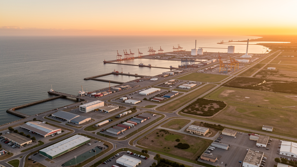
Get Matched With a Local Surveyor
Drone Survey Services Available in Brownsville, TX
Brownsville is the southernmost Texas city with 185,000 residents, anchored by SpaceX Starbase (20 miles east), the Port of Brownsville, and UT Rio Grande Valley. The LNG terminal expansion, I-69E corridor, and downtown revitalization drive construction survey demand. BRO Class C airspace and SpaceX launch TFRs create unique airspace considerations.
Drone Surveys for Brownsville's Construction Market
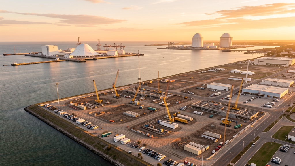
Brownsville is the southernmost Texas city and a growing aerospace and port hub. SpaceX Starbase at Boca Chica Beach (20 miles east) drives aerospace construction and infrastructure development. The Port of Brownsville expansion includes LNG export terminals, oil and gas storage, and ship repair facilities. The University of Texas Rio Grande Valley campus and the Brownsville Medical Center add institutional construction. The I-69E/US 77 corridor and the SH 550 connector drive heavy civil construction. The downtown Brownsville revitalization and the Resaca Watershed restoration projects add mixed-use and environmental survey demand. The proposed Boca Chica Village spaceport support development creates unique aerospace-adjacent survey work.
Active Developers in the Area:
Typical Project Costs in Texas
Cost ranges are based on market data for Brownsville-Harlingen. Actual pricing depends on site size, complexity, and deliverables.
| Service Type | Low End | High End |
|---|---|---|
| Topographic Survey | $1,350 | $4,000 |
| Drone Inspection | $200 | $700 |
| LiDAR Scanning | $2,200 | $7,200 |
| Environmental Monitoring | $700 | $2,800 |
| Aerial Imagery | $150 | $450 |
| Construction Monitoring | $750 | $2,500 |
| Real Estate Photography | $125 | $400 |
| Roof Inspection | $175 | $600 |
Local Airspace & Regulations in Brownsville, TX
FAA Part 107 Requirements
All commercial drone operations in Texas require the pilot to hold an active FAA Part 107 Remote Pilot Certificate. Our network surveyors are verified Part 107 holders.
State Drone Laws
Texas Government Code Chapter 423 restricts drone use over critical infrastructure facilities, including oil and gas pipelines, refineries, power plants, and water treatment facilities. HB 1484 (2023) added protections for agricultural operations and expanded penalties for drone surveillance of private property. Commercial operators must hold a valid FAA Part 107 Remote Pilot Certificate. Texas does not require a separate state drone license, but operators flying near critical infrastructure must obtain authorization from the facility owner. The Texas Department of Public Safety maintains additional guidelines for drone operations near state facilities.
Local Ordinances
Brownsville does not issue a separate city-level drone permit for commercial operators. FAA Part 107 certification and LAANC authorization for BRO Class C airspace are the primary requirements. SpaceX launch operations at Boca Chica create TFRs that can affect eastern Brownsville. Flights near the border require CBP awareness. Port of Brownsville flights require coordination.
Restricted Airspace
- Class C airspace around Brownsville/SPI International (BRO) — located 4 miles east. LAANC authorization required for commercial drone flights in eastern Brownsville.
- SpaceX Starbase — located 20 miles east at Boca Chica Beach. SpaceX launch operations create temporary flight restrictions (TFRs) that can extend over eastern Brownsville during launches and test firings. Always check NOTAMs for SpaceX launch schedules.
- US-Mexico border zone: Brownsville is a border city at the southern tip of Texas. Drone flights near the border require awareness of CBP operations.
- Port of Brownsville — major industrial port with oil and gas storage, ship repair, and industrial facilities. Drone flights over port facilities require coordination with the Port Authority.
- Severe weather: Gulf Coast hurricane zone. Hurricane Alex (2010) and Hurricane Dolly (2008) caused damage. Post-hurricane roof inspection and port facility damage assessment are major survey use cases.
Airports in the area: undefined (undefined), undefined (undefined)
Why Hire Through Aerius View in Brownsville, TX?
FAA-Certified
Every surveyor holds an active Part 107 Remote Pilot Certificate.
Local to Brownsville
Surveyors who know the Texas airspace and local permitting.
No Cost to Quote
Submit your project at no charge. Pay the surveyor directly if you proceed.
Fast Turnaround
A local surveyor contacts you within 2 business days.
How Our Brownsville Matching Process Works
We're actively building our network of FAA-certified drone operators in Brownsville, TX. Here's exactly what happens when you submit a project request.
Submit Your Project
Tell us your site location, acreage, and what you need (topographic survey, LiDAR, inspection, etc.). Takes 60 seconds. No cost, no obligation.
We Match & Vet
We identify Part 107-certified operators in Texas with the right equipment for your project. Every pilot is verified for active certification, insurance, and relevant experience in Texas airspace.
You Get Quotes
Matched surveyors contact you within 2 business days with quotes. You compare pricing, timelines, and deliverables, then choose the right fit. You pay the surveyor directly, no markup.
What Deliverables Do You Get?
Every project includes professional-grade deliverables compatible with standard construction and engineering software:
- Orthomosaic maps (GeoTIFF) for site overview and documentation
- Point clouds (LAS/LAZ) for 3D modeling and volumetric analysis
- DEM/DSM terrain models for cut/fill and grade analysis
- Contour lines (DXF/DWG, CAD-ready) for Civil 3D and Revit
- Progress reports with side-by-side comparisons for construction monitoring
- Coordinate systems matched to your project datum (State Plane, UTM, or local)
Insurance & Liability Protection
Pilot Insurance Required
Every operator in our network must carry active liability insurance. Minimum coverage: $1,000,000 general liability. Proof of insurance is verified before any pilot joins the network.
FAA Part 107 Verified
We confirm each pilot's Remote Pilot Certificate is active and in good standing through the FAA Airmen Inquiry system. Expired certificates are flagged automatically.
Equipment Documentation
Pilots list their drone models, sensors (RGB, LiDAR, thermal, multispectral), and payload specs so we can match the right equipment to your project requirements.
Site Safety Coordination
Pilots coordinate with your site superintendent for safe operations on active construction sites, including flight plans that avoid worker areas and equipment zones.
Brownsville, TX Drone Survey FAQs
Do I need a permit for a drone survey in Brownsville?
Brownsville does not issue a separate city-level drone permit for commercial operators. FAA Part 107 certification and LAANC authorization for BRO Class C airspace are the primary requirements. SpaceX launch operations at Boca Chica create TFRs that can affect eastern Brownsville. Flights near the border require CBP awareness. Port of Brownsville flights require coordination.
How much does a drone survey cost in Brownsville?
Brownsville pricing reflects the regional market. Topographic surveys typically range from $1,350 to $4,000. LiDAR scanning runs $2,200 to $7,000. Roof inspections cost $150 to $600 per building.
How does SpaceX Starbase affect drone operations in Brownsville?
SpaceX Starbase at Boca Chica Beach is 20 miles east and conducts Starship test launches that create temporary flight restrictions (TFRs) extending over eastern Brownsville. Always check NOTAMs and the SpaceX launch schedule before planning survey flights. TFRs can be activated with short notice during test campaigns.
Are there seasonal considerations for drone surveys in Brownsville?
Gulf Coast hurricane zone (June-November). Hurricane Alex (2010) and Dolly (2008) caused significant damage. Post-hurricane roof inspection and port facility damage assessment are major use cases. Summer heat requires early morning flights. SpaceX launch TFRs can occur year-round.
Can I fly a drone over the Port of Brownsville?
The Port of Brownsville is a major industrial port with LNG export terminals, oil and gas storage, and ship repair facilities. Drone flights over port facilities require coordination with the Port Authority and compliance with maritime security regulations. The port expansion creates ongoing survey demand for infrastructure documentation.
What makes Brownsville unique for drone survey work?
From SpaceX Starbase launch operations and the Port of Brownsville LNG terminal expansion to UT Rio Grande Valley and the I-69E corridor, Brownsville is the southernmost Texas city where aerospace, port, and border logistics construction drive unique survey demand under BRO Class C airspace and SpaceX TFRs.
Nearby Cities
Are You a Drone Surveyor in Brownsville?
Get pre-qualified leads in your service area. No membership fees, no monthly minimums. First lead free.
Ready to Start Your Project in Brownsville, TX?
Get matched with a local, FAA-certified surveyor. No cost, no obligation.
Request a Free Quote