Drone Survey Services in Laredo, TX
From the World Trade Bridge expansion and $300B in annual border trade to the I-35 corridor and logistics warehousing boom, Laredo is the largest inland port on the US-Mexico border where trade infrastructure and residential growth drive intense survey demand under LRD Class C airspace and border security restrictions.
Serving Webb County & the Laredo area
Request a Free Quote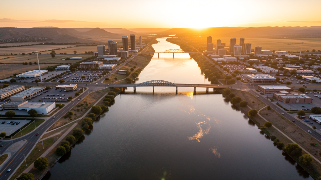
Get Matched With a Local Surveyor
Drone Survey Services Available in Laredo, TX
Laredo is the largest inland port on the US-Mexico border with 260,000 residents, processing $300+ billion in annual trade. The World Trade Bridge expansion, logistics warehousing boom, I-35 corridor improvements, and Texas A&M International University drive construction survey demand. LRD Class C airspace covers northeastern Laredo, with border security considerations throughout.
Drone Surveys for Laredo's Construction Market
Laredo is the largest inland port on the US-Mexico border, processing $300+ billion in annual trade. The World Trade Bridge and Colombia Solidarity Bridge expansions, the I-35 corridor, and the Loop 20 improvements drive heavy civil construction. The logistics and warehousing boom along the border creates massive industrial facility construction. The Laredo Medical Center and Texas A&M International University campus add institutional construction. Residential growth in north Laredo (Regency Park, San Luis Potosi) continues to convert ranchland to subdivisions. The planned high-speed rail connection to San Antonio adds infrastructure survey demand.
Active Developers in the Area:

Typical Project Costs in Texas
Cost ranges are based on market data for Laredo. Actual pricing depends on site size, complexity, and deliverables.
| Service Type | Low End | High End |
|---|---|---|
| Topographic Survey | $1,400 | $4,200 |
| Drone Inspection | $200 | $700 |
| LiDAR Scanning | $2,300 | $7,500 |
| Environmental Monitoring | $750 | $3,000 |
| Aerial Imagery | $150 | $450 |
| Construction Monitoring | $800 | $2,600 |
| Real Estate Photography | $125 | $400 |
| Roof Inspection | $175 | $600 |
Local Airspace & Regulations in Laredo, TX
FAA Part 107 Requirements
All commercial drone operations in Texas require the pilot to hold an active FAA Part 107 Remote Pilot Certificate. Our network surveyors are verified Part 107 holders.
State Drone Laws
Texas Government Code Chapter 423 restricts drone use over critical infrastructure facilities, including oil and gas pipelines, refineries, power plants, and water treatment facilities. HB 1484 (2023) added protections for agricultural operations and expanded penalties for drone surveillance of private property. Commercial operators must hold a valid FAA Part 107 Remote Pilot Certificate. Texas does not require a separate state drone license, but operators flying near critical infrastructure must obtain authorization from the facility owner. The Texas Department of Public Safety maintains additional guidelines for drone operations near state facilities.
Local Ordinances
Laredo does not issue a separate city-level drone permit for commercial operators. FAA Part 107 certification and LAANC authorization for LRD Class C airspace are the primary requirements. Drone flights near the US-Mexico border require awareness of CBP operations. Commercial filming on city property requires a permit.
Restricted Airspace
- Class C airspace around Laredo International (LRD) — located 4 miles northeast. LRD is a major cargo airport with heavy freight and military operations. LAANC authorization required for most of northeastern Laredo.
- US-Mexico border zone: Laredo is the largest inland port on the US-Mexico border. Drone flights near the border require awareness of CBP operations and potential security restrictions. Do not fly near border crossings without coordination with CBP.
- Severe weather: South Texas heat (100+ degrees F in summer) limits flight windows. Hurricane season can produce heavy rain and flooding. Flash flooding on the Rio Grande is a concern.
Airports in the area: undefined (undefined), undefined (undefined)
Why Hire Through Aerius View in Laredo, TX?
FAA-Certified
Every surveyor holds an active Part 107 Remote Pilot Certificate.
Local to Laredo
Surveyors who know the Texas airspace and local permitting.
No Cost to Quote
Submit your project at no charge. Pay the surveyor directly if you proceed.
Fast Turnaround
A local surveyor contacts you within 2 business days.
How Our Laredo Matching Process Works
We're actively building our network of FAA-certified drone operators in Laredo, TX. Here's exactly what happens when you submit a project request.
Submit Your Project
Tell us your site location, acreage, and what you need (topographic survey, LiDAR, inspection, etc.). Takes 60 seconds. No cost, no obligation.
We Match & Vet
We identify Part 107-certified operators in Texas with the right equipment for your project. Every pilot is verified for active certification, insurance, and relevant experience in Texas airspace.
You Get Quotes
Matched surveyors contact you within 2 business days with quotes. You compare pricing, timelines, and deliverables, then choose the right fit. You pay the surveyor directly, no markup.
What Deliverables Do You Get?
Every project includes professional-grade deliverables compatible with standard construction and engineering software:
- Orthomosaic maps (GeoTIFF) for site overview and documentation
- Point clouds (LAS/LAZ) for 3D modeling and volumetric analysis
- DEM/DSM terrain models for cut/fill and grade analysis
- Contour lines (DXF/DWG, CAD-ready) for Civil 3D and Revit
- Progress reports with side-by-side comparisons for construction monitoring
- Coordinate systems matched to your project datum (State Plane, UTM, or local)
Insurance & Liability Protection
Pilot Insurance Required
Every operator in our network must carry active liability insurance. Minimum coverage: $1,000,000 general liability. Proof of insurance is verified before any pilot joins the network.
FAA Part 107 Verified
We confirm each pilot's Remote Pilot Certificate is active and in good standing through the FAA Airmen Inquiry system. Expired certificates are flagged automatically.
Equipment Documentation
Pilots list their drone models, sensors (RGB, LiDAR, thermal, multispectral), and payload specs so we can match the right equipment to your project requirements.
Site Safety Coordination
Pilots coordinate with your site superintendent for safe operations on active construction sites, including flight plans that avoid worker areas and equipment zones.
Laredo, TX Drone Survey FAQs
Do I need a permit for a drone survey in Laredo?
Laredo does not issue a separate city-level drone permit for commercial operators. FAA Part 107 certification and LAANC authorization for LRD Class C airspace are the primary requirements. Drone flights near the US-Mexico border require awareness of CBP operations. Commercial filming on city property requires a permit.
How much does a drone survey cost in Laredo?
Laredo pricing reflects the regional market. Topographic surveys typically range from $1,350 to $4,000. LiDAR scanning runs $2,200 to $7,000. Roof inspections cost $150 to $600 per building.
How does the US-Mexico border affect drone operations in Laredo?
Laredo is the largest inland port on the US-Mexico border. Drone flights near border crossings require awareness of CBP operations and potential security restrictions. Do not fly near the World Trade Bridge or Colombia Solidarity Bridge without coordination with CBP. The border zone has enhanced security monitoring.
Are there seasonal considerations for drone surveys in Laredo?
South Texas heat (100+ degrees F in summer) limits flight windows to early morning and evening. Hurricane season (June-November) can produce heavy rain and Rio Grande flooding. Flash flooding is a concern. Winter offers the best flight conditions with mild temperatures and lower humidity.
Can I fly a drone over the World Trade Bridge construction?
The World Trade Bridge expansion is active construction near the border. Drone flights require coordination with TxDOT contractors, CBP, and the Laredo Bridge Authority. The area has enhanced security zones and heavy truck traffic. Survey flights should be scheduled during low-traffic periods.
What makes Laredo unique for drone survey work?
From the World Trade Bridge expansion and $300B in annual border trade to the I-35 corridor and logistics warehousing boom, Laredo is the largest inland port on the US-Mexico border where trade infrastructure and residential growth drive intense survey demand under LRD Class C airspace and border security restrictions.
Nearby Cities
Are You a Drone Surveyor in Laredo?
Get pre-qualified leads in your service area. No membership fees, no monthly minimums. First lead free.
Ready to Start Your Project in Laredo, TX?
Get matched with a local, FAA-certified surveyor. No cost, no obligation.
Request a Free Quote