Drone Survey Services in Frisco, TX
From The Star and Legacy West corporate campuses to the US 380 expansion frontier, Frisco was the fastest-growing city in America and Collin County's Dallas North Tollway corridor is still building at full throttle.
Serving Collin County & the Dallas-Fort Worth-Arlington area
Request a Free Quote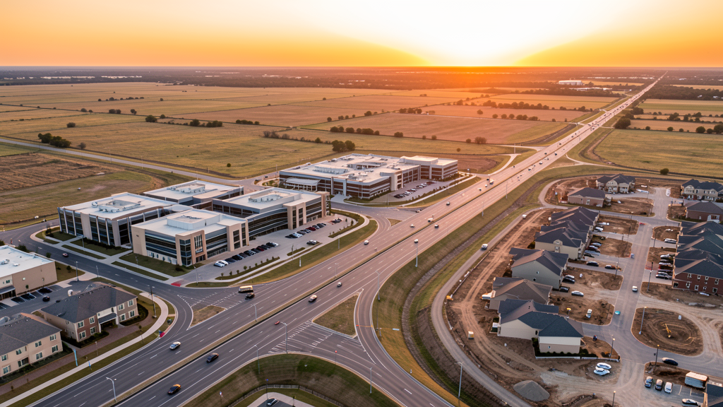
Get Matched With a Local Surveyor
Drone Survey Services Available in Frisco, TX
The Dallas-Fort Worth-Arlington metro is the fastest-growing major metro in the US, and Frisco anchors the Collin County growth corridor along the Dallas North Tollway. The city more than doubled its population from 2010 to 2024, driven by corporate campus relocations (The Star, PGA of America, Legacy West), master-planned communities, and the US 380 northern expansion. For drone surveyors, this means sustained demand for topographic surveys, construction monitoring, and LiDAR mapping across one of America's most active construction markets.
Drone Surveys for Frisco's Construction Market
Frisco was the fastest-growing city in the United States from 2010 to 2020, more than doubling from 116,000 to 212,000 residents. The Dallas North Tollway corridor is the primary growth spine, anchored by The Star (Dallas Cowboys World HQ, 91 acres), Legacy West (Liberty Mutual, JPMorgan Chase, Boeing), and the new PGA of America headquarters at Omni PGA Resort. Collin County is the fastest-growing county in the DFW metroplex, with master-planned communities in Frisco, Prosper, Celina, and McKinney generating sustained demand for topographic surveys. The US 380 corridor north of Frisco is the next major development frontier, with thousands of acres of agricultural land being converted to mixed-use and residential. Frisco's Sports City USA branding has driven continuous sports facility construction, including youth tournament venues, training complexes, and hospitality development.
Active Developers in the Area:
Typical Project Costs in Texas
Cost ranges are based on market data for Dallas-Fort Worth-Arlington. Actual pricing depends on site size, complexity, and deliverables.
| Service Type | Low End | High End |
|---|---|---|
| Topographic Survey | $1,800 | $5,000 |
| Drone Inspection | $250 | $850 |
| LiDAR Scanning | $2,800 | $9,000 |
| Environmental Monitoring | $900 | $3,500 |
| Aerial Imagery | $175 | $550 |
| Construction Monitoring | $1,000 | $3,000 |
| Real Estate Photography | $175 | $500 |
| Roof Inspection | $225 | $800 |
Local Airspace & Regulations in Frisco, TX
FAA Part 107 Requirements
All commercial drone operations in Texas require the pilot to hold an active FAA Part 107 Remote Pilot Certificate. Our network surveyors are verified Part 107 holders.
State Drone Laws
Texas Government Code Chapter 423 restricts drone use over critical infrastructure facilities, including oil and gas pipelines, refineries, power plants, and water treatment facilities. HB 1484 (2023) added protections for agricultural operations and expanded penalties for drone surveillance of private property. Commercial operators must hold a valid FAA Part 107 Remote Pilot Certificate. Texas does not require a separate state drone license, but operators flying near critical infrastructure must obtain authorization from the facility owner. The Texas Department of Public Safety maintains additional guidelines for drone operations near state facilities.
Local Ordinances
Frisco does not issue a separate city-level drone permit for commercial operators. FAA Part 107 certification and LAANC authorization for Class B and Class D airspace are the primary requirements. Commercial filming on city property requires a permit through the Frisco Parks and Recreation Department. Frisco has designated several parks as no-drone zones for takeoff and landing, including Toyota Soccer Center, Frisco Square, and areas around The Star during events. Flights from private property (with owner permission) do not require a city permit but must comply with all FAA Part 107 rules and Texas Government Code Chapter 423 critical infrastructure restrictions. The city prohibits drone flights over large public gatherings at Toyota Stadium (FC Dallas), Dr Pepper Ballpark (RoughRiders), and Comerica Center without specific FAA authorization.
Restricted Airspace
- Class B airspace around DFW International — the eastern shelf of DFW Class B extends into western Frisco, approximately 8-12 miles from the airport. LAANC authorization is required for commercial drone flights in the southwestern portion of Frisco and along the Dallas North Tollway corridor approaching DFW.
- Class B airspace around Dallas Love Field (DAL) — located 25 miles south, the outer shelves extend north but generally do not reach Frisco. However, survey work in southern Frisco near SH 121 should verify altitude shelves on FAA UAS Facility Maps.
- Class D airspace around Addison Airport (ADS) — located 10 miles south in Addison. Drone flights within 4 nautical miles require LAANC authorization. This affects survey work in southern Frisco near Legacy Drive and Stonebrook Parkway.
- Class D airspace around McKinney National Airport (TKI) — located 10 miles northeast. Drone flights within 4 nautical miles require LAANC authorization. This affects survey work in northeast Frisco near Eldorado Parkway and US 380.
- The Star (Dallas Cowboys World HQ) — critical infrastructure under TX Government Code Chapter 423. The 91-acre complex includes practice facilities, corporate offices, and a retail district. Drone flights over The Star without authorization violate state law. The facility has active security monitoring.
- PGA of America Headquarters (Omni PGA Resort) — major resort and golf complex with event-driven TFRs during PGA tournaments and corporate events. Drone flights over the resort during events may trigger temporary flight restrictions.
- Drone Racing League and tech corridor: Frisco is home to multiple tech companies and drone-related businesses along the Dallas North Tollway. While not formal restricted airspace, the high density of low-altitude drone activity in the Legacy West and The Star areas means pilots should maintain heightened situational awareness and coordinate with adjacent property owners.
Airports in the area: undefined (undefined), undefined (undefined), undefined (undefined), undefined (undefined), undefined (undefined)
Why Hire Through Aerius View in Frisco, TX?
FAA-Certified
Every surveyor holds an active Part 107 Remote Pilot Certificate.
Local to Frisco
Surveyors who know the Texas airspace and local permitting.
No Cost to Quote
Submit your project at no charge. Pay the surveyor directly if you proceed.
Fast Turnaround
A local surveyor contacts you within 2 business days.
How Our Frisco Matching Process Works
We're actively building our network of FAA-certified drone operators in Frisco, TX. Here's exactly what happens when you submit a project request.
Submit Your Project
Tell us your site location, acreage, and what you need (topographic survey, LiDAR, inspection, etc.). Takes 60 seconds. No cost, no obligation.
We Match & Vet
We identify Part 107-certified operators in Texas with the right equipment for your project. Every pilot is verified for active certification, insurance, and relevant experience in Texas airspace.
You Get Quotes
Matched surveyors contact you within 2 business days with quotes. You compare pricing, timelines, and deliverables, then choose the right fit. You pay the surveyor directly, no markup.
What Deliverables Do You Get?
Every project includes professional-grade deliverables compatible with standard construction and engineering software:
- Orthomosaic maps (GeoTIFF) for site overview and documentation
- Point clouds (LAS/LAZ) for 3D modeling and volumetric analysis
- DEM/DSM terrain models for cut/fill and grade analysis
- Contour lines (DXF/DWG, CAD-ready) for Civil 3D and Revit
- Progress reports with side-by-side comparisons for construction monitoring
- Coordinate systems matched to your project datum (State Plane, UTM, or local)
Insurance & Liability Protection
Pilot Insurance Required
Every operator in our network must carry active liability insurance. Minimum coverage: $1,000,000 general liability. Proof of insurance is verified before any pilot joins the network.
FAA Part 107 Verified
We confirm each pilot's Remote Pilot Certificate is active and in good standing through the FAA Airmen Inquiry system. Expired certificates are flagged automatically.
Equipment Documentation
Pilots list their drone models, sensors (RGB, LiDAR, thermal, multispectral), and payload specs so we can match the right equipment to your project requirements.
Site Safety Coordination
Pilots coordinate with your site superintendent for safe operations on active construction sites, including flight plans that avoid worker areas and equipment zones.
Frisco, TX Drone Survey FAQs
Do I need a permit for a drone survey in Frisco?
Frisco does not issue a separate city-level drone permit for commercial operators. FAA Part 107 certification is mandatory, and LAANC authorization is required for flights within the DFW Class B airspace shelf that covers western Frisco, or the Class D zones around Addison Airport (south) and McKinney National (northeast). Flights from private property with owner permission do not require a city permit. Commercial filming on city property may require a permit from Frisco Parks and Recreation.
How much does a drone survey cost in Frisco and Collin County?
Frisco pricing tracks slightly above the DFW metro average due to the high volume of corporate campus and mixed-use construction. Topographic surveys typically range from $1,800 to $5,000. LiDAR scanning runs $2,800 to $9,000 for large sites or wooded areas along the US 380 corridor. Roof inspections cost $225 to $800 per building. Construction monitoring is typically $1,000 to $3,000 per month for recurring flights at master-planned community sites.
Can I fly a drone near The Star or PGA of America headquarters?
The Star (Dallas Cowboys World HQ) is designated critical infrastructure under Texas Government Code Chapter 423. Drone flights over the 91-acre complex without authorization violate state law. The PGA of America headquarters at Omni PGA Resort may have event-driven TFRs during tournaments and corporate events. Always check B4UFLY and NOTAMs before flying near these facilities. Flights over adjacent commercial areas are permissible at or below 400 ft AGL with Part 107 certification.
How does DFW airport airspace affect drone operations in Frisco?
The eastern shelf of DFW Class B airspace extends into western Frisco, approximately 8-12 miles from the airport. LAANC authorization is required for commercial flights in this zone, which covers the area west of the Dallas North Tollway. Most of central and eastern Frisco falls outside Class B but may be within Class D zones of Addison or McKinney airports. Always check FAA UAS Facility Maps before flying, as altitude shelves vary significantly across the city.
Are there no-fly zones around Frisco's sports venues?
Yes. Toyota Stadium (FC Dallas), Dr Pepper Ballpark (RoughRiders), and Comerica Center have stadium TFRs during events, prohibiting drone flights within 3 nautical miles up to 3,000 ft AGL. The Stars Center and multiple youth sports complexes in the Sports City USA corridor also restrict drone operations during tournaments. Always verify event schedules before scheduling survey flights near these venues.
What makes Frisco unique for drone survey work?
Frisco is the fastest-growing city in the US over the last decade, with construction concentrated along the Dallas North Tollway corridor. The mix of corporate campuses (The Star, Legacy West, PGA HQ), master-planned communities, and the US 380 northern expansion frontier creates diverse survey demand. The city's flat Blackland Prairie terrain makes photogrammetry efficient, but the density of controlled airspace (DFW Class B, Addison Class D, McKinney Class D) means nearly every commercial flight requires LAANC authorization.
Nearby Cities
Are You a Drone Surveyor in Frisco?
Get pre-qualified leads in your service area. No membership fees, no monthly minimums. First lead free.
Ready to Start Your Project in Frisco, TX?
Get matched with a local, FAA-certified surveyor. No cost, no obligation.
Request a Free Quote