Drone Survey Services in Issaquah, WA
With the $500 million Issaquah Central development, the Highlands master-planned community expansion, and 500+ new housing units permitted in 2023-2024, Issaquah is growing as the gateway community to the Cascade Mountains on the Seattle Eastside.
Serving King County & the Seattle area
Request a Free Quote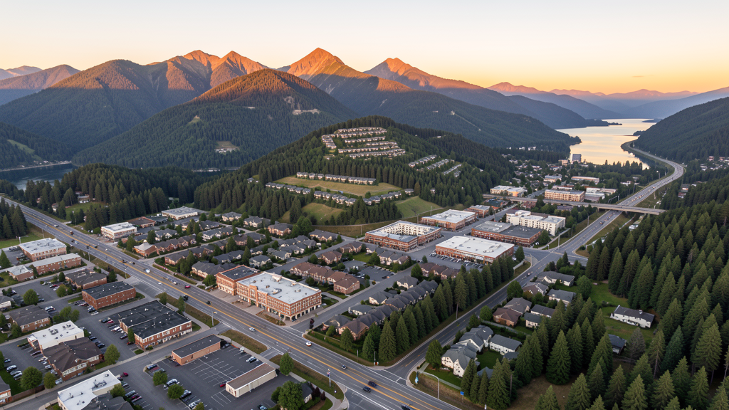
Get Matched With a Local Surveyor
Drone Survey Services Available in Issaquah, WA
Issaquah sits at the base of the Issaquah Alps on the Seattle Eastside, serving as the gateway to the Cascade Mountains. The city combines a historic downtown with the master-planned Issaquah Highlands and Grand Ridge communities. Growth is driven by tech workers seeking smaller-community living with access to outdoor recreation. Tiger Mountain, Squak Mountain, and Cougar Mountain State Parks create both terrain flying challenges and seasonal fire TFR risks. The I-90 corridor connects Issaquah to Bellevue and Seattle, making it a strategic location for Eastside construction monitoring.
Drone Surveys for Issaquah's Construction Market
Issaquah is a growing Eastside community at the base of the Issaquah Alps, with major construction including the $500 million Issaquah Central mixed-use development, the Issaquah Highlands residential expansion, and the Grand Ridge community. The city is investing in the Front Street corridor improvements and the I-90 interchange upgrades. Residential permitting exceeded 500 new units in 2023-2024, driven by Seattle Eastside tech workers seeking smaller-community living. The Issaquah Highlands master-planned community is the primary growth area.
Active Developers in the Area:

Typical Project Costs in Washington
Cost ranges are based on market data for Seattle. Actual pricing depends on site size, complexity, and deliverables.
| Service Type | Low End | High End |
|---|---|---|
| Topographic Survey | $1,500 | $5,500 |
| Drone Inspection | $950 | $3,300 |
| LiDAR Scanning | $3,200 | $8,800 |
| Environmental Monitoring | $1,500 | $5,000 |
| Aerial Imagery | $520 | $2,000 |
| Construction Monitoring | $1,150 | $4,100 |
| Real Estate Photography | $380 | $1,400 |
| Roof Inspection | $420 | $1,500 |
Local Airspace & Regulations in Issaquah, WA
FAA Part 107 Requirements
All commercial drone operations in Washington require the pilot to hold an active FAA Part 107 Remote Pilot Certificate. Our network surveyors are verified Part 107 holders.
State Drone Laws
Washington regulates drones through multiple statutes. ESSB 6001 (2015) requires law enforcement to obtain a warrant before using drones for surveillance, with exceptions for emergency response, search and rescue, and forest fire management. RCW 9A.44.115 extends voyeurism laws to drone-based image capture of private premises. RCW 46.60.130 prohibits drone interference with manned aircraft and emergency response operations. Washington does not require a separate state-level drone license for commercial operators, but all commercial drone pilots must hold a valid FAA Part 107 Remote Pilot Certificate. The state preempts local regulation of drone flight paths and navigable airspace (RCW 47.68), though cities may regulate takeoff and landing on public property they own. Washington State Parks prohibit drone takeoff and landing without a permit (WAC 352-32). Commercial operators near military installations (JBLM, Fairchild AFB, Naval Air Station Whidbey Island) must coordinate with base operations.
Local Ordinances
Issaquah does not have a formal drone permitting ordinance, but the city requests 48-hour notification for commercial drone operations in city parks. Washington State Parks (WAC 352-32) prohibit drone takeoff and landing without a permit, affecting Tiger Mountain and Squak Mountain areas. Washington ESSB 6001 governs law enforcement drone use. Flights from private property require owner permission and FAA Part 107 compliance. The Issaquah Alps create terrain and weather considerations for drone operations, with density altitude and valley wind patterns requiring careful flight planning.
Restricted Airspace
- Issaquah is at the edge of the SEA Class B outer shelf (20+ NM). Some parts of Issaquah may be in uncontrolled Class G airspace. Check FAA UAS Facility Maps for specific locations.
- S50 Issaquah airport has a small Class E transition area. Drone flights near the airport traffic pattern should maintain awareness of GA traffic. No LAANC required for most of Issaquah.
- Tiger Mountain and Squak Mountain State Parks border Issaquah. Washington State Parks prohibit drone takeoff and landing without a permit (WAC 352-32). Seasonal fire TFRs common July through October.
- Issaquah City Code requires notification for commercial drone operations in city parks including Lake Sammamish State Park, Cougar Mountain, and Issaquah Community Park. No formal permit fee but 48-hour notice required.
- Issaquah Alps create terrain considerations. Mountain operations require awareness of density altitude effects on drone performance, especially in summer months. Wind patterns through valleys can be unpredictable.
Airports in the area: undefined (undefined), undefined (undefined), undefined (undefined)
Why Hire Through Aerius View in Issaquah, WA?
FAA-Certified
Every surveyor holds an active Part 107 Remote Pilot Certificate.
Local to Issaquah
Surveyors who know the Washington airspace and local permitting.
No Cost to Quote
Submit your project at no charge. Pay the surveyor directly if you proceed.
Fast Turnaround
A local surveyor contacts you within 2 business days.
How Our Issaquah Matching Process Works
We're actively building our network of FAA-certified drone operators in Issaquah, WA. Here's exactly what happens when you submit a project request.
Submit Your Project
Tell us your site location, acreage, and what you need (topographic survey, LiDAR, inspection, etc.). Takes 60 seconds. No cost, no obligation.
We Match & Vet
We identify Part 107-certified operators in Washington with the right equipment for your project. Every pilot is verified for active certification, insurance, and relevant experience in Washington airspace.
You Get Quotes
Matched surveyors contact you within 2 business days with quotes. You compare pricing, timelines, and deliverables, then choose the right fit. You pay the surveyor directly, no markup.
What Deliverables Do You Get?
Every project includes professional-grade deliverables compatible with standard construction and engineering software:
- Orthomosaic maps (GeoTIFF) for site overview and documentation
- Point clouds (LAS/LAZ) for 3D modeling and volumetric analysis
- DEM/DSM terrain models for cut/fill and grade analysis
- Contour lines (DXF/DWG, CAD-ready) for Civil 3D and Revit
- Progress reports with side-by-side comparisons for construction monitoring
- Coordinate systems matched to your project datum (State Plane, UTM, or local)
Insurance & Liability Protection
Pilot Insurance Required
Every operator in our network must carry active liability insurance. Minimum coverage: $1,000,000 general liability. Proof of insurance is verified before any pilot joins the network.
FAA Part 107 Verified
We confirm each pilot's Remote Pilot Certificate is active and in good standing through the FAA Airmen Inquiry system. Expired certificates are flagged automatically.
Equipment Documentation
Pilots list their drone models, sensors (RGB, LiDAR, thermal, multispectral), and payload specs so we can match the right equipment to your project requirements.
Site Safety Coordination
Pilots coordinate with your site superintendent for safe operations on active construction sites, including flight plans that avoid worker areas and equipment zones.
Issaquah, WA Drone Survey FAQs
Do I need LAANC authorization to fly a drone in Issaquah?
Most of Issaquah is at the edge of the SEA Class B outer shelf. Some areas may be in uncontrolled Class G airspace. Check the FAA UAS Facility Map for your specific flight location. The S50 Issaquah airport has a small Class E transition area that may affect flights near the airport.
What terrain considerations affect drone flights near Issaquah?
The Issaquah Alps (Tiger Mountain, Squak Mountain, Cougar Mountain) create mountain flying conditions with density altitude effects in summer, valley wind patterns, and turbulence near ridge lines. Always calculate density altitude and check wind forecasts before mountain operations.
What construction activity is happening in Issaquah?
The $500 million Issaquah Central mixed-use development and the Issaquah Highlands master-planned community expansion are the largest projects. Over 500 new housing units were permitted in 2023-2024. The I-90 interchange upgrades and Front Street corridor improvements are the main infrastructure investments.
Can I fly a drone over Tiger Mountain State Park?
No, not without a permit. Washington State Parks (WAC 352-32) prohibit drone takeoff and landing without a permit. Tiger Mountain and Squak Mountain State Parks border Issaquah and require permits for commercial drone operations.
How much does a drone survey cost in Issaquah?
Topographic surveys in Issaquah range from $1,500 to $5,500. LiDAR scanning costs $3,200 to $8,800. Construction monitoring runs $1,150 to $4,100. Pricing reflects the Seattle Eastside market with some terrain premium for mountain-area work.
Nearby Cities
Are You a Drone Surveyor in Issaquah?
Get pre-qualified leads in your service area. No membership fees, no monthly minimums. First lead free.
Ready to Start Your Project in Issaquah, WA?
Get matched with a local, FAA-certified surveyor. No cost, no obligation.
Request a Free Quote