Drone Survey Services in Kirkland, WA
With the Village at Totem Lake redevelopment, Google campus expansion, and 800+ new housing units permitted in 2023-2024, Kirkland is experiencing significant construction activity driven by its waterfront location and Seattle Eastside tech corridor growth.
Serving King County & the Seattle area
Request a Free Quote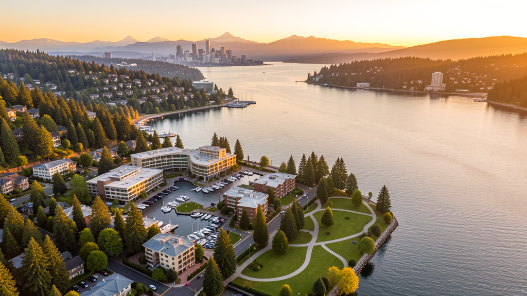
Get Matched With a Local Surveyor
Drone Survey Services Available in Kirkland, WA
Kirkland sits on the eastern shore of Lake Washington in the Seattle Eastside tech corridor, home to Google Kirkland and numerous technology companies. The city combines a vibrant downtown waterfront with the rapidly redeveloping Totem Lake area. The Cross Kirkland Corridor, a former rail line turned trail, is spurring transit-oriented development. Lake Washington and the Cascade foothills create diverse terrain for survey work. SEA Class B airspace covers the city, requiring LAANC authorization for all commercial drone operations.
Drone Surveys for Kirkland's Construction Market
Kirkland is experiencing significant construction activity driven by its tech-sector growth and waterfront location. Major projects include the downtown Kirkland Urban mixed-use development, the Parkplace Center expansion, and the Google Kirkland campus expansion. Residential permitting exceeded 800 new housing units in 2023-2024, driven by Google employees and Seattle Eastside tech workers. The city is investing in the Cross Kirkland Corridor trail and transit improvements along NE 85th Street. The Totem Lake area is seeing major mixed-use redevelopment including the Village at Totem Lake.
Active Developers in the Area:

Typical Project Costs in Washington
Cost ranges are based on market data for Seattle. Actual pricing depends on site size, complexity, and deliverables.
| Service Type | Low End | High End |
|---|---|---|
| Topographic Survey | $1,600 | $5,800 |
| Drone Inspection | $1,050 | $3,600 |
| LiDAR Scanning | $3,400 | $9,200 |
| Environmental Monitoring | $1,600 | $5,200 |
| Aerial Imagery | $550 | $2,200 |
| Construction Monitoring | $1,250 | $4,400 |
| Real Estate Photography | $400 | $1,500 |
| Roof Inspection | $450 | $1,600 |
Local Airspace & Regulations in Kirkland, WA
FAA Part 107 Requirements
All commercial drone operations in Washington require the pilot to hold an active FAA Part 107 Remote Pilot Certificate. Our network surveyors are verified Part 107 holders.
State Drone Laws
Washington regulates drones through multiple statutes. ESSB 6001 (2015) requires law enforcement to obtain a warrant before using drones for surveillance, with exceptions for emergency response, search and rescue, and forest fire management. RCW 9A.44.115 extends voyeurism laws to drone-based image capture of private premises. RCW 46.60.130 prohibits drone interference with manned aircraft and emergency response operations. Washington does not require a separate state-level drone license for commercial operators, but all commercial drone pilots must hold a valid FAA Part 107 Remote Pilot Certificate. The state preempts local regulation of drone flight paths and navigable airspace (RCW 47.68), though cities may regulate takeoff and landing on public property they own. Washington State Parks prohibit drone takeoff and landing without a permit (WAC 352-32). Commercial operators near military installations (JBLM, Fairchild AFB, Naval Air Station Whidbey Island) must coordinate with base operations.
Local Ordinances
Kirkland City Code requires a Special Use Permit for commercial drone operations taking off or landing on city-owned property including Marina Park, Heritage Park, and Juanita Beach Park. The permit costs $50 with a 7-day processing period through Kirkland Parks and Community Services. Flights from private property require owner permission and FAA Part 107 compliance. Washington ESSB 6001 governs law enforcement drone use. Google Kirkland campus security may enforce additional no-drone policies for flights near their facilities.
Restricted Airspace
- Kirkland falls within the SEA Class B outer shelf (10-20 NM ring). Commercial drone flights require LAANC authorization. Use Aloft or DroneUp apps for instant approval.
- Paine Field (PAE) Class D airspace affects north Kirkland near the Juanita area. Flights within 4 NM of PAE may require LAANC authorization depending on altitude.
- Lake Washington creates over-water flight considerations. Drone flights over the lake must maintain visual line of sight. Do not fly beyond visual range over water.
- Kirkland City Code requires a permit for commercial drone operations on city property including Marina Park, Heritage Park, and Juanita Beach Park. Permit costs $50 with 7-day processing.
- Google Kirkland campus has security considerations similar to Microsoft. Coordinate with corporate security for flights near the campus.
Airports in the area: undefined (undefined), undefined (undefined), undefined (undefined)
Why Hire Through Aerius View in Kirkland, WA?
FAA-Certified
Every surveyor holds an active Part 107 Remote Pilot Certificate.
Local to Kirkland
Surveyors who know the Washington airspace and local permitting.
No Cost to Quote
Submit your project at no charge. Pay the surveyor directly if you proceed.
Fast Turnaround
A local surveyor contacts you within 2 business days.
How Our Kirkland Matching Process Works
We're actively building our network of FAA-certified drone operators in Kirkland, WA. Here's exactly what happens when you submit a project request.
Submit Your Project
Tell us your site location, acreage, and what you need (topographic survey, LiDAR, inspection, etc.). Takes 60 seconds. No cost, no obligation.
We Match & Vet
We identify Part 107-certified operators in Washington with the right equipment for your project. Every pilot is verified for active certification, insurance, and relevant experience in Washington airspace.
You Get Quotes
Matched surveyors contact you within 2 business days with quotes. You compare pricing, timelines, and deliverables, then choose the right fit. You pay the surveyor directly, no markup.
What Deliverables Do You Get?
Every project includes professional-grade deliverables compatible with standard construction and engineering software:
- Orthomosaic maps (GeoTIFF) for site overview and documentation
- Point clouds (LAS/LAZ) for 3D modeling and volumetric analysis
- DEM/DSM terrain models for cut/fill and grade analysis
- Contour lines (DXF/DWG, CAD-ready) for Civil 3D and Revit
- Progress reports with side-by-side comparisons for construction monitoring
- Coordinate systems matched to your project datum (State Plane, UTM, or local)
Insurance & Liability Protection
Pilot Insurance Required
Every operator in our network must carry active liability insurance. Minimum coverage: $1,000,000 general liability. Proof of insurance is verified before any pilot joins the network.
FAA Part 107 Verified
We confirm each pilot's Remote Pilot Certificate is active and in good standing through the FAA Airmen Inquiry system. Expired certificates are flagged automatically.
Equipment Documentation
Pilots list their drone models, sensors (RGB, LiDAR, thermal, multispectral), and payload specs so we can match the right equipment to your project requirements.
Site Safety Coordination
Pilots coordinate with your site superintendent for safe operations on active construction sites, including flight plans that avoid worker areas and equipment zones.
Kirkland, WA Drone Survey FAQs
Do I need LAANC authorization to fly a drone in Kirkland?
Yes. Kirkland falls within the SEA Class B outer shelf requiring LAANC authorization for all commercial drone flights. North Kirkland near Juanita may also be affected by Paine Field Class D airspace. Use the Aloft or DroneUp LAANC apps for instant approval.
What construction activity is happening in Kirkland?
Major projects include the downtown Kirkland Urban mixed-use development, Village at Totem Lake redevelopment, Google campus expansion, and the Cross Kirkland Corridor trail. Over 800 new housing units were permitted in 2023-2024.
Can I fly a drone over Lake Washington from Kirkland?
FAA regulations require maintaining visual line of sight. Do not fly beyond visual range over water. Lake Washington flights also need to account for SEA Class B airspace restrictions. Low-altitude flights near the shoreline may be permitted with LAANC authorization.
Can I fly a drone in Kirkland parks?
Not without a permit. Kirkland City Code requires a Special Use Permit for drone takeoff and landing from city parks including Marina Park, Heritage Park, and Juanita Beach Park. The permit costs $50 with 7-day processing.
How much does a drone survey cost in Kirkland?
LiDAR survey pricing in Kirkland ranges from $3,400 to $9,200. Topographic surveys range from $1,600 to $5,800. Construction monitoring runs $1,250 to $4,400. Pricing reflects the premium Seattle Eastside market with strong tech-sector demand.
Nearby Cities
Are You a Drone Surveyor in Kirkland?
Get pre-qualified leads in your service area. No membership fees, no monthly minimums. First lead free.
Ready to Start Your Project in Kirkland, WA?
Get matched with a local, FAA-certified surveyor. No cost, no obligation.
Request a Free Quote