Drone Survey Services in Redmond, WA
The $1 billion Microsoft campus expansion (17 buildings, 2.5 million sq ft) is the largest private construction project in Washington state, driving a massive wave of supporting residential and commercial development in Redmond and the Overlake area.
Serving King County & the Seattle area
Request a Free Quote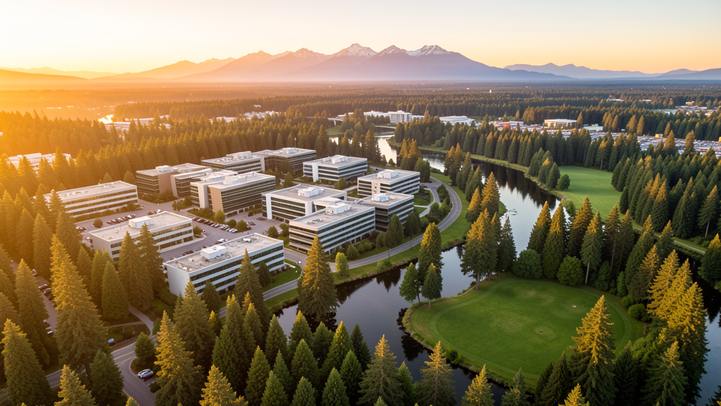
Get Matched With a Local Surveyor
Drone Survey Services Available in Redmond, WA
Redmond sits on the Seattle Eastside as the home of Microsoft and one of the fastest-growing tech hubs in the Pacific Northwest. The city is anchored by the Microsoft Redmond campus, which is undergoing a $1 billion expansion. The Sound Transit East Link light rail extension connects Redmond to Seattle and Bellevue, fueling transit-oriented development in downtown and Overlake. The Sammamish River Valley and surrounding forests create diverse terrain for drone survey work, while the SEA Class B airspace requires LAANC authorization for all commercial flights. The city has a strong residential market driven by tech-sector employment and excellent schools.
Drone Surveys for Redmond's Construction Market
Redmond is experiencing massive construction driven by the $1 billion Microsoft campus expansion, the largest private construction project in Washington state. The expanded campus will add 17 new buildings and 2.5 million square feet. Downtown Redmond is undergoing revitalization with mixed-use development along the Redmond Central Connector. The Sound Transit East Link light rail extension is under construction through downtown. Residential permitting exceeded 1,200 new units in 2023-2024, driven by Microsoft employees and tech-sector growth. The Overlake area near Microsoft is seeing dense residential and retail development.
Active Developers in the Area:

Typical Project Costs in Washington
Cost ranges are based on market data for Seattle. Actual pricing depends on site size, complexity, and deliverables.
| Service Type | Low End | High End |
|---|---|---|
| Topographic Survey | $1,700 | $6,000 |
| Drone Inspection | $1,100 | $3,800 |
| LiDAR Scanning | $3,600 | $9,500 |
| Environmental Monitoring | $1,700 | $5,500 |
| Aerial Imagery | $580 | $2,300 |
| Construction Monitoring | $1,300 | $4,600 |
| Real Estate Photography | $420 | $1,600 |
| Roof Inspection | $480 | $1,700 |
Local Airspace & Regulations in Redmond, WA
FAA Part 107 Requirements
All commercial drone operations in Washington require the pilot to hold an active FAA Part 107 Remote Pilot Certificate. Our network surveyors are verified Part 107 holders.
State Drone Laws
Washington regulates drones through multiple statutes. ESSB 6001 (2015) requires law enforcement to obtain a warrant before using drones for surveillance, with exceptions for emergency response, search and rescue, and forest fire management. RCW 9A.44.115 extends voyeurism laws to drone-based image capture of private premises. RCW 46.60.130 prohibits drone interference with manned aircraft and emergency response operations. Washington does not require a separate state-level drone license for commercial operators, but all commercial drone pilots must hold a valid FAA Part 107 Remote Pilot Certificate. The state preempts local regulation of drone flight paths and navigable airspace (RCW 47.68), though cities may regulate takeoff and landing on public property they own. Washington State Parks prohibit drone takeoff and landing without a permit (WAC 352-32). Commercial operators near military installations (JBLM, Fairchild AFB, Naval Air Station Whidbey Island) must coordinate with base operations.
Local Ordinances
Redmond City Code requires a Special Use Permit for commercial drone operations taking off or landing on city-owned property including Marymoor Park and Farrel-McWhirter Park. The permit costs $50 with a 7-day processing period through Redmond Parks and Recreation. Flights from private property require owner permission and FAA Part 107 compliance. Microsoft campus security zones may have additional restrictions enforced by private security. Washington ESSB 6001 governs law enforcement drone use. WSDOT permits required for drone inspections of state highways including SR 520.
Restricted Airspace
- Redmond falls within the SEA Class B outer shelf (10-20 NM ring). Commercial drone flights require LAANC authorization. Use Aloft or DroneUp apps for instant approval up to 400 ft AGL.
- Microsoft Redmond campus has security zones. Drone flights over or near Microsoft facilities may require coordination with corporate security. The campus spans over 500 acres and includes restricted areas.
- Redmond City Code requires a permit for commercial drone operations taking off or landing on city property including Marymoor Park, Farrel-McWhirter Park, and Anderson Park. Permit costs $50 with 7-day processing.
- Sammamish River Trail and Redmond Watershed Preserve are managed recreation areas. Drone takeoff and landing prohibited without permit. Seasonal wildlife restrictions may apply.
- The SR 520 corridor and upcoming Sound Transit light rail construction create infrastructure inspection zones requiring WSDOT coordination.
Airports in the area: undefined (undefined), undefined (undefined), undefined (undefined)
Why Hire Through Aerius View in Redmond, WA?
FAA-Certified
Every surveyor holds an active Part 107 Remote Pilot Certificate.
Local to Redmond
Surveyors who know the Washington airspace and local permitting.
No Cost to Quote
Submit your project at no charge. Pay the surveyor directly if you proceed.
Fast Turnaround
A local surveyor contacts you within 2 business days.
How Our Redmond Matching Process Works
We're actively building our network of FAA-certified drone operators in Redmond, WA. Here's exactly what happens when you submit a project request.
Submit Your Project
Tell us your site location, acreage, and what you need (topographic survey, LiDAR, inspection, etc.). Takes 60 seconds. No cost, no obligation.
We Match & Vet
We identify Part 107-certified operators in Washington with the right equipment for your project. Every pilot is verified for active certification, insurance, and relevant experience in Washington airspace.
You Get Quotes
Matched surveyors contact you within 2 business days with quotes. You compare pricing, timelines, and deliverables, then choose the right fit. You pay the surveyor directly, no markup.
What Deliverables Do You Get?
Every project includes professional-grade deliverables compatible with standard construction and engineering software:
- Orthomosaic maps (GeoTIFF) for site overview and documentation
- Point clouds (LAS/LAZ) for 3D modeling and volumetric analysis
- DEM/DSM terrain models for cut/fill and grade analysis
- Contour lines (DXF/DWG, CAD-ready) for Civil 3D and Revit
- Progress reports with side-by-side comparisons for construction monitoring
- Coordinate systems matched to your project datum (State Plane, UTM, or local)
Insurance & Liability Protection
Pilot Insurance Required
Every operator in our network must carry active liability insurance. Minimum coverage: $1,000,000 general liability. Proof of insurance is verified before any pilot joins the network.
FAA Part 107 Verified
We confirm each pilot's Remote Pilot Certificate is active and in good standing through the FAA Airmen Inquiry system. Expired certificates are flagged automatically.
Equipment Documentation
Pilots list their drone models, sensors (RGB, LiDAR, thermal, multispectral), and payload specs so we can match the right equipment to your project requirements.
Site Safety Coordination
Pilots coordinate with your site superintendent for safe operations on active construction sites, including flight plans that avoid worker areas and equipment zones.
Redmond, WA Drone Survey FAQs
Do I need LAANC authorization to fly a drone in Redmond?
Yes. Redmond falls within the SEA Class B outer shelf requiring LAANC authorization for all commercial drone flights. Use the Aloft or DroneUp LAANC apps to request instant approval up to 400 ft AGL.
What is driving the construction boom in Redmond?
The $1 billion Microsoft campus expansion is the largest private construction project in Washington state, adding 17 buildings and 2.5 million square feet. The Sound Transit East Link light rail extension and downtown mixed-use development are also major drivers. Over 1,200 new housing units were permitted in 2023-2024.
Can I fly a drone over the Microsoft campus?
Microsoft campus security zones may restrict drone operations. The 500-acre campus includes areas enforced by private security. While FAA Part 107 governs airspace, coordinate with Microsoft security before flying over or near campus facilities.
Can I fly a drone over Marymoor Park?
Not without a permit. Redmond City Code requires a Special Use Permit for drone takeoff and landing from city parks including Marymoor Park. The permit costs $50 with 7-day processing through Redmond Parks and Recreation.
How much does a drone LiDAR survey cost in Redmond?
LiDAR survey pricing in Redmond ranges from $3,600 to $9,500, reflecting the premium Seattle Eastside market. Standard topographic surveys range from $1,700 to $6,000. Construction monitoring runs $1,300 to $4,600.
Nearby Cities
Are You a Drone Surveyor in Redmond?
Get pre-qualified leads in your service area. No membership fees, no monthly minimums. First lead free.
Ready to Start Your Project in Redmond, WA?
Get matched with a local, FAA-certified surveyor. No cost, no obligation.
Request a Free Quote