Drone Survey Services in Pearland, TX
From the SH 288 managed lane corridor and Shadow Creek Ranch to NASA JSC spillover and the HCA medical campus, Pearland has grown from 37,000 to 130,000 in 20 years making it one of Houston's fastest-growing south suburbs where HOU Class C and hurricane-zone weather shape every survey mission.
Serving Brazoria County & the Houston-The Woodlands-Sugar Land area
Request a Free Quote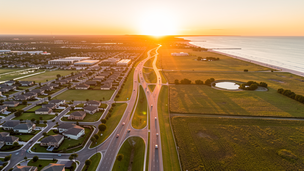
Get Matched With a Local Surveyor
Drone Survey Services Available in Pearland, TX
The Houston-The Woodlands-Sugar Land metro is one of the largest construction markets in the US, and Pearland is a key south suburb that has grown from 37,000 to 130,000 in 20 years. The SH 288 managed lane corridor, master-planned communities (Shadow Creek Ranch, Silverlake), and proximity to NASA Johnson Space Center drive diverse construction survey demand. HOU Class C and SGR Class D airspace coverage makes LAANC authorization essential for most of the city.
Drone Surveys for Pearland's Construction Market
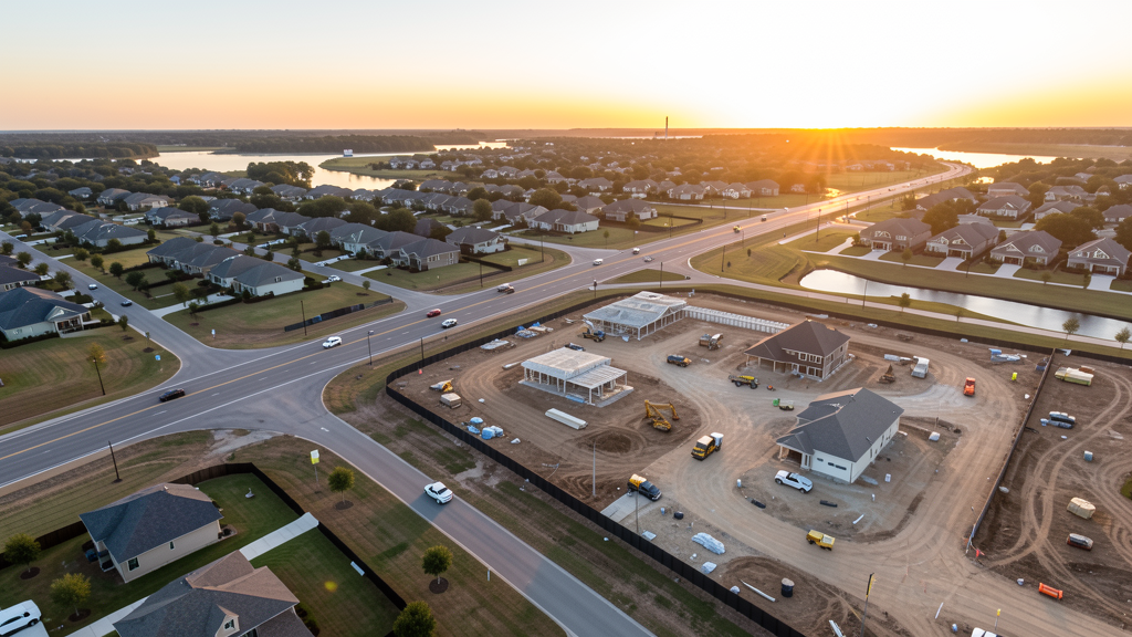
Pearland is one of the fastest-growing Houston metro suburbs, with a population that has grown from 37,000 to 130,000 in 20 years. The city is anchored by the SH 288 freeway corridor, which has been widened with managed lanes connecting to downtown Houston. Master-planned communities including Shadow Creek Ranch (3,500 acres), Silverlake, and Highland Glen are the primary residential growth drivers. The Pearland Town Center mixed-use development and the SH 288 medical corridor (with the HCA Houston Healthcare Pearland campus) add commercial and institutional construction. The Beltway 8/Sam Houston Tollway corridor through northern Pearland supports commercial and retail development. The city's proximity to NASA Johnson Space Center and the Clear Lake industrial corridor creates spillover commercial demand. Brazoria County is one of the fastest-growing counties in the Houston metro.
Active Developers in the Area:
Typical Project Costs in Texas
Cost ranges are based on market data for Houston-The Woodlands-Sugar Land. Actual pricing depends on site size, complexity, and deliverables.
| Service Type | Low End | High End |
|---|---|---|
| Topographic Survey | $1,600 | $4,800 |
| Drone Inspection | $225 | $800 |
| LiDAR Scanning | $2,600 | $8,800 |
| Environmental Monitoring | $850 | $3,400 |
| Aerial Imagery | $175 | $500 |
| Construction Monitoring | $900 | $2,800 |
| Real Estate Photography | $150 | $450 |
| Roof Inspection | $200 | $750 |
Local Airspace & Regulations in Pearland, TX
FAA Part 107 Requirements
All commercial drone operations in Texas require the pilot to hold an active FAA Part 107 Remote Pilot Certificate. Our network surveyors are verified Part 107 holders.
State Drone Laws
Texas Government Code Chapter 423 restricts drone use over critical infrastructure facilities, including oil and gas pipelines, refineries, power plants, and water treatment facilities. HB 1484 (2023) added protections for agricultural operations and expanded penalties for drone surveillance of private property. Commercial operators must hold a valid FAA Part 107 Remote Pilot Certificate. Texas does not require a separate state drone license, but operators flying near critical infrastructure must obtain authorization from the facility owner. The Texas Department of Public Safety maintains additional guidelines for drone operations near state facilities.
Local Ordinances
Pearland does not issue a separate city-level drone permit for commercial operators. FAA Part 107 certification and LAANC authorization for HOU Class C and SGR Class D airspace are the primary requirements. Commercial filming on city property requires a permit through the Pearland Parks and Recreation Department. Drone takeoff and landing in city parks requires a special use permit, including Centennial Park, Independence Park, and Pearland Sports Complex. Flights from private property (with owner permission) do not require a city permit but must comply with all FAA Part 107 rules and Texas Government Code Chapter 423 critical infrastructure restrictions.
Restricted Airspace
- Class C airspace around Houston Hobby (HOU) — located 8 miles north. HOU Class C shelves extend into northern Pearland, covering the SH 288 corridor and the Pearland Town Center area. LAANC authorization required for commercial drone flights north of FM 518.
- Class D airspace around Sugar Land Regional Airport (SGR) — located 10 miles west. SGR Class D extends into western Pearland, covering the Shadow Creek Ranch area. LAANC authorization required.
- Class B airspace around Houston Intercontinental (IAH) — northeastern Pearland may fall within the southern shelves of IAH Class B. Check FAA UAS Facility Maps for altitude restrictions in the far northeastern corner of the city.
- NASA Johnson Space Center — located 12 miles southeast. While not formal restricted airspace, JSC has enhanced security zones. Drone flights near JSC should be coordinated with NASA security, especially during launch events and testing operations.
- Pearland Regional Airport (LVJ) — general aviation airport within city limits. Uncontrolled Class E airspace but active GA traffic including flight training. Monitor CTAF and maintain visual separation.
- Shadow Creek Ranch and Silverlake — large MPCs with active construction zones. Drone flights over construction sites require coordination with site managers per FAA Part 107.39.
- Severe weather: Pearland is in the Houston metro hurricane risk zone. Hurricane season (June-November) can produce high winds, tornadoes, and flooding. Post-hurricane roof inspection and flood damage documentation is a major drone survey use case. The city experienced significant flooding during Hurricane Harvey (2017) and Tax Day floods (2016).
Airports in the area: undefined (undefined), undefined (undefined), undefined (undefined)
Why Hire Through Aerius View in Pearland, TX?
FAA-Certified
Every surveyor holds an active Part 107 Remote Pilot Certificate.
Local to Pearland
Surveyors who know the Texas airspace and local permitting.
No Cost to Quote
Submit your project at no charge. Pay the surveyor directly if you proceed.
Fast Turnaround
A local surveyor contacts you within 2 business days.
How Our Pearland Matching Process Works
We're actively building our network of FAA-certified drone operators in Pearland, TX. Here's exactly what happens when you submit a project request.
Submit Your Project
Tell us your site location, acreage, and what you need (topographic survey, LiDAR, inspection, etc.). Takes 60 seconds. No cost, no obligation.
We Match & Vet
We identify Part 107-certified operators in Texas with the right equipment for your project. Every pilot is verified for active certification, insurance, and relevant experience in Texas airspace.
You Get Quotes
Matched surveyors contact you within 2 business days with quotes. You compare pricing, timelines, and deliverables, then choose the right fit. You pay the surveyor directly, no markup.
What Deliverables Do You Get?
Every project includes professional-grade deliverables compatible with standard construction and engineering software:
- Orthomosaic maps (GeoTIFF) for site overview and documentation
- Point clouds (LAS/LAZ) for 3D modeling and volumetric analysis
- DEM/DSM terrain models for cut/fill and grade analysis
- Contour lines (DXF/DWG, CAD-ready) for Civil 3D and Revit
- Progress reports with side-by-side comparisons for construction monitoring
- Coordinate systems matched to your project datum (State Plane, UTM, or local)
Insurance & Liability Protection
Pilot Insurance Required
Every operator in our network must carry active liability insurance. Minimum coverage: $1,000,000 general liability. Proof of insurance is verified before any pilot joins the network.
FAA Part 107 Verified
We confirm each pilot's Remote Pilot Certificate is active and in good standing through the FAA Airmen Inquiry system. Expired certificates are flagged automatically.
Equipment Documentation
Pilots list their drone models, sensors (RGB, LiDAR, thermal, multispectral), and payload specs so we can match the right equipment to your project requirements.
Site Safety Coordination
Pilots coordinate with your site superintendent for safe operations on active construction sites, including flight plans that avoid worker areas and equipment zones.
Pearland, TX Drone Survey FAQs
Do I need a permit for a drone survey in Pearland?
Pearland does not issue a separate city-level drone permit for commercial operators. FAA Part 107 certification is mandatory. LAANC authorization is required for northern Pearland within HOU Class C and western Pearland within SGR Class D. Drone takeoff and landing in city parks requires a special use permit from Pearland Parks and Recreation.
How much does a drone survey cost in Pearland?
Pearland pricing is consistent with the Houston metro average. Topographic surveys typically range from $1,600 to $4,800. LiDAR scanning runs $2,600 to $8,800. Roof inspections cost $200 to $750 per building. Construction monitoring is typically $900 to $2,800 per month for recurring flights at MPC sites like Shadow Creek Ranch or Silverlake.
How does Houston Hobby Airport affect drone operations in Pearland?
Houston Hobby (HOU) is located 8 miles north and its Class C airspace extends into northern Pearland, covering the SH 288 corridor and Pearland Town Center area. LAANC authorization is required for all commercial drone flights north of FM 518. HOU has heavy commercial airline traffic, so always check FAA UAS Facility Maps for altitude restrictions.
Are there special considerations for flying near NASA Johnson Space Center?
JSC is located 12 miles southeast. While not formal restricted airspace, JSC has enhanced security zones. Drone flights near JSC should be coordinated with NASA security, especially during launch events and testing operations. The Clear Lake industrial corridor between Pearland and JSC has active commercial and aerospace manufacturing development.
Does Pearland's hurricane risk affect drone survey planning?
Yes. Pearland is in the Houston metro hurricane zone (June-November). Post-hurricane roof inspection and flood damage documentation is a major drone survey use case. The city experienced severe flooding during Hurricane Harvey (2017) and the Tax Day floods (2016). Survey work in flood-prone areas near Clear Creek and Mustang Bayou requires weather monitoring and coordination with Brazoria County Emergency Management.
What makes Pearland unique for drone survey work?
Pearland has grown from 37,000 to 130,000 in 20 years, driven by the SH 288 managed lane corridor and massive MPCs (Shadow Creek Ranch, Silverlake). The city's proximity to NASA Johnson Space Center and the Clear Lake aerospace corridor creates commercial spillover. HOU Class C airspace in the north and SGR Class D in the west make LAANC planning essential. Hurricane-zone weather creates a significant post-storm inspection market.
Nearby Cities
Are You a Drone Surveyor in Pearland?
Get pre-qualified leads in your service area. No membership fees, no monthly minimums. First lead free.
Ready to Start Your Project in Pearland, TX?
Get matched with a local, FAA-certified surveyor. No cost, no obligation.
Request a Free Quote