Drone Survey Services in Silverthorne, CO
Silverthorne is anchored by the downtown Silverthorne Core revitalization and Blue River corridor projects, with mountain-resort construction demand sustained by year-round tourism and workforce housing needs.
Serving Summit County & the Breckenridge MSA area
Request a Free Quote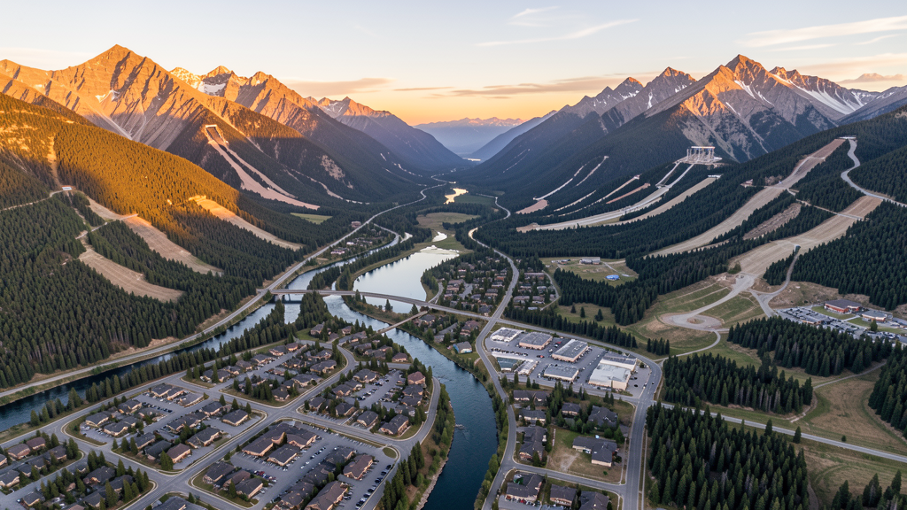
Get Matched With a Local Surveyor
Drone Survey Services Available in Silverthorne, CO
Silverthorne serves as the northern gateway to Summit County and sits at the intersection of I-70 and Highway 9, making it a strategic hub for Colorado mountain corridor development. The town benefits from proximity to four major ski resorts (Keystone, Breckenridge, Copper Mountain, Arapahoe Basin) which drives both commercial and residential construction. The high-altitude mountain environment creates unique survey challenges requiring specialized equipment.
Drone Surveys for Silverthorne's Construction Market
Silverthorne is experiencing moderate growth driven by resort-area and workforce housing demand. The town is investing in the Silverthorne Core downtown revitalization plan, which includes mixed-use development along the Blue River corridor. Infrastructure spending includes water system upgrades and the Blue River restoration project. Summit County has seen construction spending growth of approximately 4-6% annually through 2024, with significant investment in affordable housing projects and resort infrastructure.
Active Developers in the Area:

Typical Project Costs in Colorado
Cost ranges are based on market data for Breckenridge MSA. Actual pricing depends on site size, complexity, and deliverables.
| Service Type | Low End | High End |
|---|---|---|
| Topographic Survey | $1,800 | $6,500 |
| Drone Inspection | $1,200 | $5,000 |
| LiDAR Scanning | $4,000 | $12,000 |
| Environmental Monitoring | $1,500 | $6,000 |
| Aerial Imagery | $800 | $3,500 |
| Construction Monitoring | $1,500 | $7,000 |
| Real Estate Photography | $600 | $2,800 |
| Roof Inspection | $500 | $2,200 |
Local Airspace & Regulations in Silverthorne, CO
FAA Part 107 Requirements
All commercial drone operations in Colorado require the pilot to hold an active FAA Part 107 Remote Pilot Certificate. Our network surveyors are verified Part 107 holders.
State Drone Laws
Colorado HB 1070 (2023) aligns state drone law with federal FAA Part 107 requirements. The law prohibits local municipalities from regulating drone flight paths or airspace, but allows cities to regulate takeoff and landing on public property. Colorado does not require a separate state-level drone license. Commercial drone operators must hold a valid FAA Part 107 Remote Pilot Certificate and comply with all federal regulations. The Colorado Department of Transportation has additional guidelines for drone operations near state highways and infrastructure.
Local Ordinances
Silverthorne Municipal Code Chapter 12.20 prohibits unauthorized aircraft including model aircraft and drones from operating in town parks without prior authorization from the Parks and Recreation Department. Town Code 5.16 requires a business license for commercial drone operators doing business within town limits. Commercial filming and photography in Silverthorne requires a permit from the Town Clerk with proof of FAA Part 107 certification. Summit County regulations apply to unincorporated areas surrounding Silverthorne.
Restricted Airspace
- Silverthorne sits in mountainous Class E airspace with no Class B/C/D overlay. Standard Part 107 rules apply.
- Eagles Nest Wilderness Area directly north of Silverthorne prohibits all motorized aircraft including drones per USFS regulations.
- White River National Forest surrounds the area; commercial drone operations require a special use permit from the White River National Forest office.
- Dillon Dam and reservoir infrastructure adjacent to Silverthorne may trigger security concerns and overflight restrictions.
- Wildfire TFRs possible in surrounding national forest lands during summer and fall. Check NOTAMs before every flight.
Airports in the area: undefined (undefined), undefined (undefined), undefined (undefined), undefined (undefined)
Why Hire Through Aerius View in Silverthorne, CO?
FAA-Certified
Every surveyor holds an active Part 107 Remote Pilot Certificate.
Local to Silverthorne
Surveyors who know the Colorado airspace and local permitting.
No Cost to Quote
Submit your project at no charge. Pay the surveyor directly if you proceed.
Fast Turnaround
A local surveyor contacts you within 2 business days.
How Our Silverthorne Matching Process Works
We're actively building our network of FAA-certified drone operators in Silverthorne, CO. Here's exactly what happens when you submit a project request.
Submit Your Project
Tell us your site location, acreage, and what you need (topographic survey, LiDAR, inspection, etc.). Takes 60 seconds. No cost, no obligation.
We Match & Vet
We identify Part 107-certified operators in Colorado with the right equipment for your project. Every pilot is verified for active certification, insurance, and relevant experience in Colorado airspace.
You Get Quotes
Matched surveyors contact you within 2 business days with quotes. You compare pricing, timelines, and deliverables, then choose the right fit. You pay the surveyor directly, no markup.
What Deliverables Do You Get?
Every project includes professional-grade deliverables compatible with standard construction and engineering software:
- Orthomosaic maps (GeoTIFF) for site overview and documentation
- Point clouds (LAS/LAZ) for 3D modeling and volumetric analysis
- DEM/DSM terrain models for cut/fill and grade analysis
- Contour lines (DXF/DWG, CAD-ready) for Civil 3D and Revit
- Progress reports with side-by-side comparisons for construction monitoring
- Coordinate systems matched to your project datum (State Plane, UTM, or local)
Insurance & Liability Protection
Pilot Insurance Required
Every operator in our network must carry active liability insurance. Minimum coverage: $1,000,000 general liability. Proof of insurance is verified before any pilot joins the network.
FAA Part 107 Verified
We confirm each pilot's Remote Pilot Certificate is active and in good standing through the FAA Airmen Inquiry system. Expired certificates are flagged automatically.
Equipment Documentation
Pilots list their drone models, sensors (RGB, LiDAR, thermal, multispectral), and payload specs so we can match the right equipment to your project requirements.
Site Safety Coordination
Pilots coordinate with your site superintendent for safe operations on active construction sites, including flight plans that avoid worker areas and equipment zones.
Silverthorne, CO Drone Survey FAQs
What airspace restrictions affect drone flights in Silverthorne?
Silverthorne sits in mountainous Class E airspace, so standard Part 107 rules apply with no Class B/C/D overlay. However, the Eagles Nest Wilderness Area directly north of town prohibits all motorized aircraft including drones per USFS regulations. Operators must also be aware of high-elevation terrain (Silverthorne sits at approximately 9,000 feet MSL), which affects drone performance and battery life.
Can I fly a drone in Silverthorne town parks?
Under Silverthorne Municipal Code Chapter 12.20, unauthorized aircraft including model aircraft and drones are prohibited in town parks without prior authorization from the Parks and Recreation Department. Operators should contact Silverthorne Parks and Recreation for permits before flying in any municipal park.
Do I need a business license to operate a commercial drone service in Silverthorne?
Yes. Under Town Code 5.16, any business operating within Silverthorne town limits must obtain a business license. Commercial drone operators must also hold a valid FAA Part 107 Remote Pilot Certificate and carry appropriate liability insurance.
How does the high altitude affect drone survey operations in Silverthorne?
At approximately 9,000 feet elevation, the reduced air density significantly impacts drone performance. Most multirotor drones experience reduced lift capacity and shorter battery life (often 15-20% reduction). Operators should use high-altitude-optimized drones with larger propellers and high-capacity batteries to maintain survey-grade accuracy in these conditions.
What major construction projects are driving drone survey demand in Silverthorne?
The Silverthorne Core downtown revitalization, Blue River restoration project, and multiple workforce housing developments are the primary drivers. The town is also investing in water infrastructure upgrades. Summit County overall is seeing 4-6% annual construction spending growth, creating steady demand for topographic and construction progress surveys.
Nearby Cities
Are You a Drone Surveyor in Silverthorne?
Get pre-qualified leads in your service area. No membership fees, no monthly minimums. First lead free.
Ready to Start Your Project in Silverthorne, CO?
Get matched with a local, FAA-certified surveyor. No cost, no obligation.
Request a Free Quote