Drone Survey Services in Glenwood Springs, CO
Glenwood Springs construction is defined by narrow valley constraints, I-70 corridor infrastructure demands, and the Roaring Fork Valley luxury housing market, creating specialized needs for steep-terrain aerial survey and CDOT-coordinated monitoring work.
Serving Garfield County & the Glenwood Springs MSA area
Request a Free Quote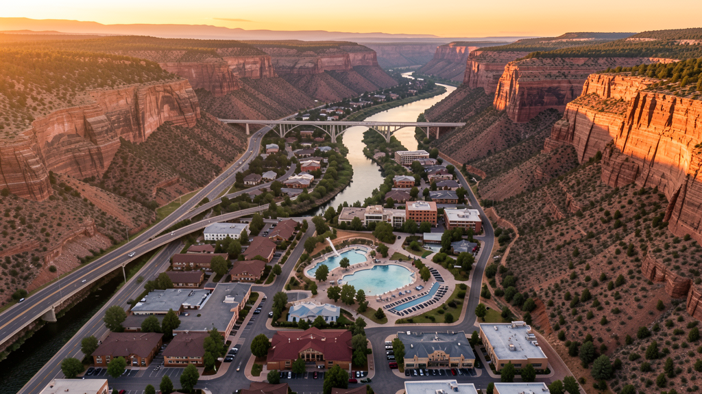
Get Matched With a Local Surveyor
Drone Survey Services Available in Glenwood Springs, CO
Glenwood Springs is the geographic hub of the Roaring Fork Valley at the confluence of the Colorado and Roaring Fork Rivers, serving as the gateway to Aspen and the broader mountain resort economy. The construction market is driven by healthcare expansion, highway infrastructure repair, and residential demand in a valley where buildable land is scarce and expensive.
Drone Surveys for Glenwood Springs's Construction Market
Glenwood Springs serves as the geographic and commercial hub of the Roaring Fork Valley, with construction activity driven by the I-70 corridor, healthcare expansion, and resort-adjacent residential demand. Major projects include the Valley View Hospital expansion, CDOT I-70 Glenwood Canyon repair and debris flow mitigation infrastructure, and residential development along the Highway 82 corridor toward Carbondale. Growth rate is approximately 2% annually, constrained by limited flat buildable land in the narrow river valley.
Active Developers in the Area:

Typical Project Costs in Colorado
Cost ranges are based on market data for Glenwood Springs MSA. Actual pricing depends on site size, complexity, and deliverables.
| Service Type | Low End | High End |
|---|---|---|
| Topographic Survey | $1,300 | $4,800 |
| Drone Inspection | $850 | $3,100 |
| LiDAR Scanning | $2,700 | $8,200 |
| Environmental Monitoring | $1,050 | $3,600 |
| Aerial Imagery | $650 | $2,600 |
| Construction Monitoring | $950 | $3,600 |
| Real Estate Photography | $425 | $1,550 |
| Roof Inspection | $525 | $1,850 |
Local Airspace & Regulations in Glenwood Springs, CO
FAA Part 107 Requirements
All commercial drone operations in Colorado require the pilot to hold an active FAA Part 107 Remote Pilot Certificate. Our network surveyors are verified Part 107 holders.
State Drone Laws
Colorado HB 1070 (2023) aligns state drone law with federal FAA Part 107 requirements. The law prohibits local municipalities from regulating drone flight paths or airspace, but allows cities to regulate takeoff and landing on public property. Colorado does not require a separate state-level drone license. Commercial drone operators must hold a valid FAA Part 107 Remote Pilot Certificate and comply with all federal regulations. The Colorado Department of Transportation has additional guidelines for drone operations near state highways and infrastructure.
Local Ordinances
Glenwood Springs Municipal Code Chapter 12.04 regulates activities in city parks; drone operation in parks requires city authorization. Glenwood Springs Municipal Code Chapter 9 covers nuisances with privacy provisions applicable to low-altitude drone flights over residential areas. Commercial filming permits are issued through the Glenwood Springs Community Development Department for city-owned property and public rights-of-way. The city expects Part 107 compliance and coordination with the uncontrolled airport traffic pattern at KGWS.
Restricted Airspace
- White River National Forest completely surrounds Glenwood Springs; commercial drone operations require a special use permit from the White River National Forest office in Glenwood Springs.
- Flat Tops Wilderness Area (north of Glenwood Springs) prohibits all drone operations as motorized equipment is banned in wilderness areas.
- Hanging Lake USFS-managed area prohibits drone use in the trail corridor and lake surroundings due to fragile ecosystem and National Natural Landmark status.
- Glenwood Canyon I-70 corridor is managed by CDOT; drone operations near the highway require CDOT coordination. The canyon has been subject to frequent closures since the Grizzly Creek Fire (2020) due to debris flows.
- Wildfire TFRs are common in the White River National Forest. The Grizzly Creek Fire burn area continues to generate debris flow events requiring aerial response and TFRs.
Airports in the area: undefined (undefined), undefined (undefined), undefined (undefined), undefined (undefined)
Why Hire Through Aerius View in Glenwood Springs, CO?
FAA-Certified
Every surveyor holds an active Part 107 Remote Pilot Certificate.
Local to Glenwood Springs
Surveyors who know the Colorado airspace and local permitting.
No Cost to Quote
Submit your project at no charge. Pay the surveyor directly if you proceed.
Fast Turnaround
A local surveyor contacts you within 2 business days.
How Our Glenwood Springs Matching Process Works
We're actively building our network of FAA-certified drone operators in Glenwood Springs, CO. Here's exactly what happens when you submit a project request.
Submit Your Project
Tell us your site location, acreage, and what you need (topographic survey, LiDAR, inspection, etc.). Takes 60 seconds. No cost, no obligation.
We Match & Vet
We identify Part 107-certified operators in Colorado with the right equipment for your project. Every pilot is verified for active certification, insurance, and relevant experience in Colorado airspace.
You Get Quotes
Matched surveyors contact you within 2 business days with quotes. You compare pricing, timelines, and deliverables, then choose the right fit. You pay the surveyor directly, no markup.
What Deliverables Do You Get?
Every project includes professional-grade deliverables compatible with standard construction and engineering software:
- Orthomosaic maps (GeoTIFF) for site overview and documentation
- Point clouds (LAS/LAZ) for 3D modeling and volumetric analysis
- DEM/DSM terrain models for cut/fill and grade analysis
- Contour lines (DXF/DWG, CAD-ready) for Civil 3D and Revit
- Progress reports with side-by-side comparisons for construction monitoring
- Coordinate systems matched to your project datum (State Plane, UTM, or local)
Insurance & Liability Protection
Pilot Insurance Required
Every operator in our network must carry active liability insurance. Minimum coverage: $1,000,000 general liability. Proof of insurance is verified before any pilot joins the network.
FAA Part 107 Verified
We confirm each pilot's Remote Pilot Certificate is active and in good standing through the FAA Airmen Inquiry system. Expired certificates are flagged automatically.
Equipment Documentation
Pilots list their drone models, sensors (RGB, LiDAR, thermal, multispectral), and payload specs so we can match the right equipment to your project requirements.
Site Safety Coordination
Pilots coordinate with your site superintendent for safe operations on active construction sites, including flight plans that avoid worker areas and equipment zones.
Glenwood Springs, CO Drone Survey FAQs
What type of airspace is at Glenwood Springs Municipal Airport and what does that mean for drone operators?
Glenwood Springs Municipal Airport (KGWS) is a non-towered airport with a Class E surface area. There is no control tower, so LAANC authorization is not required, but Part 107 pilots must still comply with all FAA regulations including maintaining visual line of sight and yielding right-of-way to manned aircraft. The airport sits within city limits near the Roaring Fork River, and the traffic pattern extends over residential areas. Pilots should monitor CTAF frequency 122.8 MHz.
Can I fly a drone in Glenwood Canyon near I-70?
Glenwood Canyon is a narrow, heavily managed transportation corridor along I-70 operated by CDOT. Drone operations near the highway require coordination with CDOT and must not interfere with traffic or emergency operations. The canyon has been subject to frequent closures since the Grizzly Creek Fire of 2020 due to debris flows. Operators should contact the CDOT Region 3 office in Glenwood Springs for coordination.
Do I need a Forest Service permit for drone survey work in the White River National Forest around Glenwood Springs?
Yes. The White River National Forest completely surrounds Glenwood Springs, and the Forest Supervisor office is located in Glenwood Springs itself. Commercial drone operations require a special use permit involving FAA Part 107 certification, proof of insurance, and a description of project scope. Wilderness areas including the Flat Tops Wilderness prohibit all drone operations. The permit process can take 60-90 days.
Are drones allowed at Hanging Lake or other Glenwood Springs area natural attractions?
Hanging Lake, a USFS-managed area with a reservation-only trail system, prohibits drone operations within the area including the trail corridor and lake surroundings. The area has special protections due to its fragile ecosystem and National Natural Landmark status. Commercial operators should check with the Eagle-Holy Cross Ranger District for current restrictions.
How does the Roaring Fork Valley housing market affect demand for drone survey services in Glenwood Springs?
The Roaring Fork Valley, stretching from Glenwood Springs to Aspen, has some of the most expensive real estate in the Mountain West, creating strong demand for aerial photography, topographic survey, and construction monitoring services. Residential development is constrained by steep terrain and limited flat land, making accurate topographic mapping essential for builders working on hillside lots.
Nearby Cities
Are You a Drone Surveyor in Glenwood Springs?
Get pre-qualified leads in your service area. No membership fees, no monthly minimums. First lead free.
Ready to Start Your Project in Glenwood Springs, CO?
Get matched with a local, FAA-certified surveyor. No cost, no obligation.
Request a Free Quote