Drone Survey Services in Tucson, AZ
From the Broadway corridor widening and UA campus expansion to Raytheon campus growth and master-planned communities in Marana and Sahuarita, Tucson is a top-tier secondary construction market where desert heat and military airspace shape every survey mission.
Serving Pima County & the Tucson area
Request a Free Quote
Get Matched With a Local Surveyor
Drone Survey Services Available in Tucson, AZ
The Tucson metro is driven by the University of Arizona expansion, Raytheon Missiles and Defense campus growth, and Davis-Monthan AFB infrastructure improvements. Marana and Sahuarita are experiencing rapid residential growth with master-planned communities like Dove Mountain and Rancho Sahuarita.
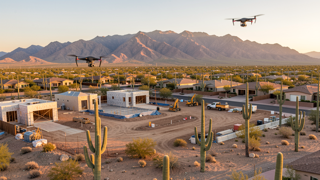
Drone Surveys for Tucson's Construction Market
Tucson is a top-tier secondary construction market driven by the University of Arizona expansion, Raytheon Missiles and Defense campus growth, and the Davis-Monthan AFB infrastructure improvements. The Broadway Boulevard corridor is undergoing a multi-phase widening and mixed-use development. Downtown Tucson has seen sustained revitalization with the Mercado District, the modern streetcar corridor, and adaptive reuse projects. Marana and Sahuarita are experiencing rapid residential growth, with master-planned communities like Dove Mountain and Rancho Sahuarita generating demand for topographic surveys. The mining sector in Pima County (Freeport-McMoRan Sierrita and Mission mines) also drives demand for aerial survey and monitoring.
Active Developers in the Area:
Typical Project Costs in Arizona
Cost ranges are based on market data for Tucson. Actual pricing depends on site size, complexity, and deliverables.
| Service Type | Low End | High End |
|---|---|---|
| Topographic Survey | $1,800 | $4,500 |
| Drone Inspection | $250 | $850 |
| LiDAR Scanning | $2,800 | $8,500 |
| Environmental Monitoring | $800 | $3,200 |
| Aerial Imagery | $175 | $500 |
| Construction Monitoring | $1,200 | $3,200 |
| Real Estate Photography | $175 | $450 |
| Roof Inspection | $225 | $800 |
Local Airspace & Regulations in Tucson, AZ
FAA Part 107 Requirements
All commercial drone operations in Arizona require the pilot to hold an active FAA Part 107 Remote Pilot Certificate. Our network surveyors are verified Part 107 holders.
State Drone Laws
Arizona SB 1449 (2016) was the first state law regulating drone use, prohibiting drone operations that interfere with law enforcement, emergency responders, or wildfire suppression efforts. The law prohibits drone flights within 3 miles of a wildfire or prescribed burn and makes violation a class 1 misdemeanor. ARS Title 13 Chapter 29 Article 3 restricts drone surveillance of private property and weaponization of drones. Commercial operators must hold a valid FAA Part 107 Remote Pilot Certificate. Arizona does not require a separate state drone license, but operators must comply with FAA Part 107 rules and any local ordinances. The Arizona Department of Public Safety maintains guidelines for drone operations near critical infrastructure including power plants, dams, and military installations.
Local Ordinances
Tucson requires a commercial drone permit for operations taking off or landing on city-owned property, including parks and recreation areas. The Tucson Parks and Recreation Department issues permits for commercial drone flights during public events. Flights from private property with owner permission do not require a city permit but must comply with FAA Part 107 rules. Tucson International Airport airspace coordination is managed through LAANC. The city prohibits drone flights over stadiums and large public gatherings at Arizona Stadium and McKale Center without specific authorization. Pima County also requires permits for drone flights in county parks and preserves.
Restricted Airspace
- Class C airspace around Tucson International (TUS) — extends 5 nautical miles from the airport, surface to 10,000 ft MSL. LAANC authorization required for all commercial drone flights within this zone.
- Davis-Monthan Air Force Base (DMA) — active military installation with restricted airspace. Drone flights within 5 miles require prior coordination with base operations. The 309th Aerospace Maintenance and Regeneration Group (AMARG) boneyard is on-base.
- Saguaro National Park (East and West districts) — National Park Service prohibits all drone operations within park boundaries. Violations are federal misdemeanors.
- Pima County parks prohibit drone takeoff/landing without a special use permit. Reid Park, Brandi Fenton Memorial Park, and Gene C. Reid Park are actively managed.
- Military Operating Areas (MOAs) east of Tucson near the Rincon Mountains — active military training routes may restrict drone operations at certain altitudes and times.
Airports in the area: undefined (undefined), undefined (undefined), undefined (undefined), undefined (undefined)
Why Hire Through Aerius View in Tucson, AZ?
FAA-Certified
Every surveyor holds an active Part 107 Remote Pilot Certificate.
Local to Tucson
Surveyors who know the Arizona airspace and local permitting.
No Cost to Quote
Submit your project at no charge. Pay the surveyor directly if you proceed.
Fast Turnaround
A local surveyor contacts you within 2 business days.
How Our Tucson Matching Process Works
We're actively building our network of FAA-certified drone operators in Tucson, AZ. Here's exactly what happens when you submit a project request.
Submit Your Project
Tell us your site location, acreage, and what you need (topographic survey, LiDAR, inspection, etc.). Takes 60 seconds. No cost, no obligation.
We Match & Vet
We identify Part 107-certified operators in Arizona with the right equipment for your project. Every pilot is verified for active certification, insurance, and relevant experience in Arizona airspace.
You Get Quotes
Matched surveyors contact you within 2 business days with quotes. You compare pricing, timelines, and deliverables, then choose the right fit. You pay the surveyor directly, no markup.
What Deliverables Do You Get?
Every project includes professional-grade deliverables compatible with standard construction and engineering software:
- Orthomosaic maps (GeoTIFF) for site overview and documentation
- Point clouds (LAS/LAZ) for 3D modeling and volumetric analysis
- DEM/DSM terrain models for cut/fill and grade analysis
- Contour lines (DXF/DWG, CAD-ready) for Civil 3D and Revit
- Progress reports with side-by-side comparisons for construction monitoring
- Coordinate systems matched to your project datum (State Plane, UTM, or local)
Insurance & Liability Protection
Pilot Insurance Required
Every operator in our network must carry active liability insurance. Minimum coverage: $1,000,000 general liability. Proof of insurance is verified before any pilot joins the network.
FAA Part 107 Verified
We confirm each pilot's Remote Pilot Certificate is active and in good standing through the FAA Airmen Inquiry system. Expired certificates are flagged automatically.
Equipment Documentation
Pilots list their drone models, sensors (RGB, LiDAR, thermal, multispectral), and payload specs so we can match the right equipment to your project requirements.
Site Safety Coordination
Pilots coordinate with your site superintendent for safe operations on active construction sites, including flight plans that avoid worker areas and equipment zones.
Tucson, AZ Drone Survey FAQs
Do I need a permit for a drone survey in Tucson?
You need a commercial drone permit only if you plan to take off or land on city-owned property, including parks. Surveys conducted from private property with owner permission do not require a Tucson city permit. All commercial drone operations require an FAA Part 107 Remote Pilot Certificate.
Can drones fly near Tucson International Airport?
Tucson International (TUS) has Class C controlled airspace extending 5 nautical miles. Commercial drone flights within this airspace require LAANC authorization from the FAA. Our network surveyors handle all LAANC approvals as part of the service.
Are there restricted military airspace zones near Tucson?
Yes. Davis-Monthan Air Force Base has restricted military airspace and active flight operations, including the AMARG aircraft boneyard. Drone flights within 5 miles of the base require prior coordination. Military Operating Areas east of Tucson may also restrict operations at certain altitudes.
Can I fly drones in Saguaro National Park?
No. The National Park Service prohibits all drone operations within Saguaro National Park boundaries, both the East (Rincon Mountain District) and West (Tucson Mountain District) units. Violations are federal misdemeanors. Plan survey routes that avoid park boundaries.
How much does a drone survey cost in the Tucson area?
Topographic surveys in the Tucson metro typically range from $1,800 to $4,500. Roof inspections run $225-$800. LiDAR scanning for larger or mountainous sites can cost $2,800-$8,500. Real estate drone photography starts at $175.
Does the desert heat affect drone operations in Tucson?
Yes. Summer temperatures regularly exceed 105 degrees, which reduces battery life and can trigger automatic thermal shutdowns in drone batteries. Morning flights before 9 AM are strongly recommended June through September. Our local surveyors schedule flights to avoid peak heat and account for density altitude at Tucson 2,400 ft elevation.
Nearby Cities
Are You a Drone Surveyor in Tucson?
Get pre-qualified leads in your service area. No membership fees, no monthly minimums. First lead free.
Ready to Start Your Project in Tucson, AZ?
Get matched with a local, FAA-certified surveyor. No cost, no obligation.
Request a Free Quote