Drone Survey Services in Erie, CO
Erie is experiencing rapid residential and infrastructure growth with major master-planned communities like Colliers Hill driving consistent demand for aerial surveying and construction monitoring services.
Serving Boulder County & the Denver-Aurora-Lakewood MSA area
Request a Free Quote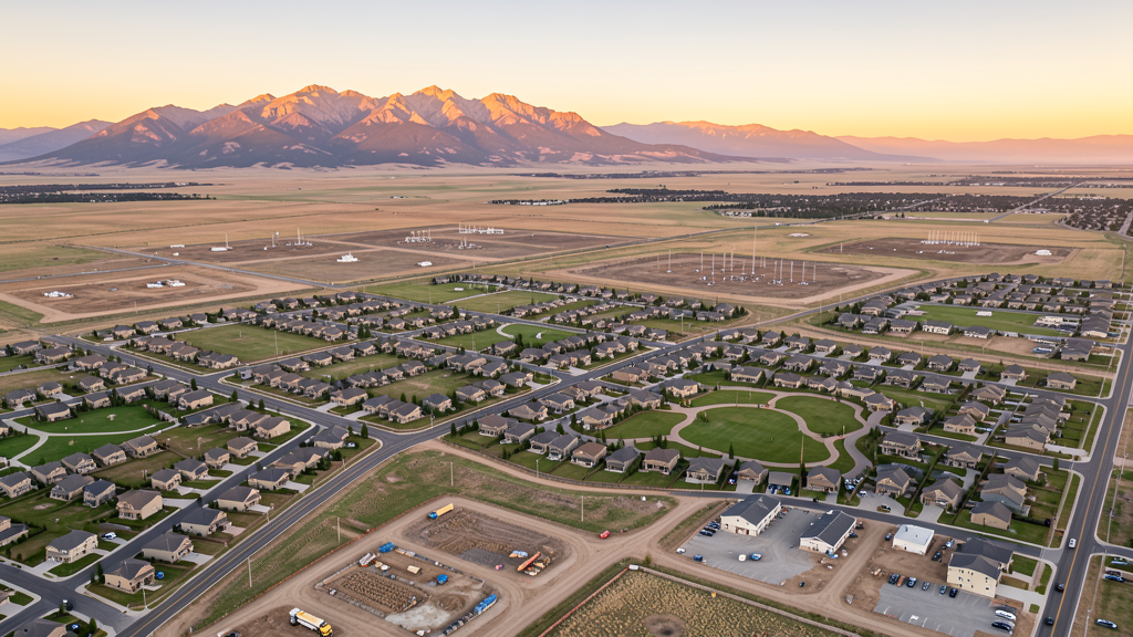
Get Matched With a Local Surveyor
Drone Survey Services Available in Erie, CO
The Northern Colorado Front Range corridor from Erie through Frederick and into the Carbon Valley represents one of the most active residential construction markets in the state. Erie straddles the Boulder-Weld county line, positioning it between the higher-cost Boulder County market to the west and the rapidly expanding Weld County energy and residential corridor to the east.
Drone Surveys for Erie's Construction Market
Erie is one of the fastest-growing municipalities in Colorado, with annual growth rates of 4-5% and building permit volume routinely exceeding 400-500 new residential units per year. Major infrastructure investments include the Erie Parkway expansion, a new water treatment facility, and the Erie Recreation Center expansion. The town has approved multiple master-planned communities totaling thousands of new residential units, with continued investment in schools, fire stations, and utility infrastructure along the Colorado 7 corridor.
Active Developers in the Area:

Typical Project Costs in Colorado
Cost ranges are based on market data for Denver-Aurora-Lakewood MSA. Actual pricing depends on site size, complexity, and deliverables.
| Service Type | Low End | High End |
|---|---|---|
| Topographic Survey | $1,500 | $5,000 |
| Drone Inspection | $800 | $3,500 |
| LiDAR Scanning | $3,000 | $12,000 |
| Environmental Monitoring | $1,200 | $5,000 |
| Aerial Imagery | $400 | $2,000 |
| Construction Monitoring | $1,000 | $4,500 |
| Real Estate Photography | $300 | $1,500 |
| Roof Inspection | $250 | $1,200 |
Local Airspace & Regulations in Erie, CO
FAA Part 107 Requirements
All commercial drone operations in Colorado require the pilot to hold an active FAA Part 107 Remote Pilot Certificate. Our network surveyors are verified Part 107 holders.
State Drone Laws
Colorado HB 1070 (2023) aligns state drone law with federal FAA Part 107 requirements. The law prohibits local municipalities from regulating drone flight paths or airspace, but allows cities to regulate takeoff and landing on public property. Colorado does not require a separate state-level drone license. Commercial drone operators must hold a valid FAA Part 107 Remote Pilot Certificate and comply with all federal regulations. The Colorado Department of Transportation has additional guidelines for drone operations near state highways and infrastructure.
Local Ordinances
Erie Municipal Code Chapter 11 prohibits drones from taking off or landing in town parks without prior authorization from the Parks and Recreation Department. Commercial operators must provide proof of FAA Part 107 certification and liability insurance. Erie Municipal Code Section 11-2-30 addresses operation of unmanned aircraft on town property, requiring compliance with all FAA regulations. Commercial filming including drone cinematography requires a film permit from the Town Clerk office with fee approximately $100 per day.
Restricted Airspace
- KBJC Class D surface area to 8,000 MSL within approximately 4.5 nm. Southern portion of Erie falls within or near this Class D shelf. LAANC authorization required for flights in this area.
- KDEN Class B outer shelves at 10,000-12,000 MSL. Standard drone operations below 400 AGL not impacted.
- Rocky Flats National Wildlife Refuge (8 miles south between Erie and Broomfield). Former nuclear weapons production site; USFWS restrictions on overflights.
- Erie sits on the Wattenberg Gas Field; numerous well pads and production facilities throughout the area. FAA may issue TFRs around critical energy infrastructure.
- Boulder County Open Space parcels adjacent to Erie have restrictions on drone operations per county regulations.
Airports in the area: undefined (undefined), undefined (undefined), undefined (undefined), undefined (undefined)
Why Hire Through Aerius View in Erie, CO?
FAA-Certified
Every surveyor holds an active Part 107 Remote Pilot Certificate.
Local to Erie
Surveyors who know the Colorado airspace and local permitting.
No Cost to Quote
Submit your project at no charge. Pay the surveyor directly if you proceed.
Fast Turnaround
A local surveyor contacts you within 2 business days.
How Our Erie Matching Process Works
We're actively building our network of FAA-certified drone operators in Erie, CO. Here's exactly what happens when you submit a project request.
Submit Your Project
Tell us your site location, acreage, and what you need (topographic survey, LiDAR, inspection, etc.). Takes 60 seconds. No cost, no obligation.
We Match & Vet
We identify Part 107-certified operators in Colorado with the right equipment for your project. Every pilot is verified for active certification, insurance, and relevant experience in Colorado airspace.
You Get Quotes
Matched surveyors contact you within 2 business days with quotes. You compare pricing, timelines, and deliverables, then choose the right fit. You pay the surveyor directly, no markup.
What Deliverables Do You Get?
Every project includes professional-grade deliverables compatible with standard construction and engineering software:
- Orthomosaic maps (GeoTIFF) for site overview and documentation
- Point clouds (LAS/LAZ) for 3D modeling and volumetric analysis
- DEM/DSM terrain models for cut/fill and grade analysis
- Contour lines (DXF/DWG, CAD-ready) for Civil 3D and Revit
- Progress reports with side-by-side comparisons for construction monitoring
- Coordinate systems matched to your project datum (State Plane, UTM, or local)
Insurance & Liability Protection
Pilot Insurance Required
Every operator in our network must carry active liability insurance. Minimum coverage: $1,000,000 general liability. Proof of insurance is verified before any pilot joins the network.
FAA Part 107 Verified
We confirm each pilot's Remote Pilot Certificate is active and in good standing through the FAA Airmen Inquiry system. Expired certificates are flagged automatically.
Equipment Documentation
Pilots list their drone models, sensors (RGB, LiDAR, thermal, multispectral), and payload specs so we can match the right equipment to your project requirements.
Site Safety Coordination
Pilots coordinate with your site superintendent for safe operations on active construction sites, including flight plans that avoid worker areas and equipment zones.
Erie, CO Drone Survey FAQs
How does the proximity to Rocky Mountain Metropolitan Airport (KBJC) affect drone operations in Erie?
The KBJC Class D airspace extends to 8,000 feet MSL within approximately 4.5 nautical miles of the airport. The southern portion of Erie falls within or near this Class D shelf, meaning commercial drone pilots operating in that area must obtain LAANC authorization before flying. Flights in the northern portions of Erie are generally outside Class D but should still check current airspace via the B4UFLY app or LAANC providers.
What major construction projects are driving drone survey demand in Erie?
The Colliers Hill master-planned community by Shea Homes is one of the largest residential developments in Boulder County, with over 2,700 planned units requiring ongoing topographic surveys, construction monitoring, and earthwork verification. Additionally, the Erie Commons mixed-use development and Erie Parkway corridor improvements generate consistent demand for aerial surveying and progress documentation.
Are there restrictions on flying drones in Erie parks?
Yes. Erie Municipal Code prohibits drone takeoff and landing in town parks without prior authorization from the Parks and Recreation Department. Commercial operators must provide proof of FAA Part 107 certification and liability insurance. Operators should contact the town for a use permit before conducting surveys in park areas.
How do oil and gas operations in the Erie area impact drone survey planning?
Erie sits above the Wattenberg Gas Field, with numerous active well pads and production facilities throughout the area. The FAA may issue temporary flight restrictions around critical energy infrastructure. Drone operators should verify current TFRs before flying near oil and gas sites and coordinate with site operators when surveying adjacent properties.
Do I need a film permit for commercial drone photography in Erie?
Yes. Under Erie business regulations for commercial filming, any commercial filming activity including drone cinematography requires a film permit from the Town Clerk office. The permit fee is approximately $100 per day, and operators must show proof of FAA Part 107 certification and liability insurance coverage.
Nearby Cities
Are You a Drone Surveyor in Erie?
Get pre-qualified leads in your service area. No membership fees, no monthly minimums. First lead free.
Ready to Start Your Project in Erie, CO?
Get matched with a local, FAA-certified surveyor. No cost, no obligation.
Request a Free Quote