Drone Survey Services in Thornton, CO
Thornton explosive residential growth, driven by master-planned communities like Todd Creek Farms and the 136th-168th Avenue corridor, makes it one of Colorado hottest markets for construction-phase drone survey and progress monitoring.
Serving Adams County & the Denver-Aurora-Lakewood MSA area
Request a Free Quote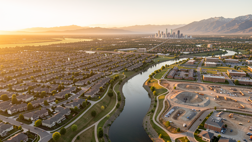
Get Matched With a Local Surveyor
Drone Survey Services Available in Thornton, CO
Thornton is the fastest-growing Denver suburb, with population growth exceeding 8% since 2020 and thousands of new housing units approved across its northern expansion corridor. The city construction market is dominated by large-scale residential development and supporting infrastructure, including the Thornton Water Project pipeline and commercial development at Larkridge and Thornton Crossroads. Drone surveyors benefit from relatively less-restrictive airspace in northern Thornton, though the southern tier requires LAANC coordination for DEN Class B and BJC Class D airspace.
Drone Surveys for Thornton's Construction Market
Thornton is the fastest-growing Denver suburb, with massive residential development in northern areas and the Todd Creek Farms master-planned community driving single-family construction. The city has approved thousands of new housing units since 2020, with major annexations extending north toward 168th Avenue. Infrastructure investment includes the Thornton Water Project (pipeline from Chimney Hollow Reservoir, approximately 75 miles), the N Line commuter rail extension study, and expanded commercial development at Larkridge and Thornton Crossroads.
Active Developers in the Area:

Typical Project Costs in Colorado
Cost ranges are based on market data for Denver-Aurora-Lakewood MSA. Actual pricing depends on site size, complexity, and deliverables.
| Service Type | Low End | High End |
|---|---|---|
| Topographic Survey | $1,000 | $4,000 |
| Drone Inspection | $700 | $2,800 |
| LiDAR Scanning | $2,200 | $7,500 |
| Environmental Monitoring | $1,300 | $4,500 |
| Aerial Imagery | $500 | $1,800 |
| Construction Monitoring | $900 | $3,200 |
| Real Estate Photography | $250 | $1,000 |
| Roof Inspection | $200 | $800 |
Local Airspace & Regulations in Thornton, CO
FAA Part 107 Requirements
All commercial drone operations in Colorado require the pilot to hold an active FAA Part 107 Remote Pilot Certificate. Our network surveyors are verified Part 107 holders.
State Drone Laws
Colorado HB 1070 (2023) aligns state drone law with federal FAA Part 107 requirements. The law prohibits local municipalities from regulating drone flight paths or airspace, but allows cities to regulate takeoff and landing on public property. Colorado does not require a separate state-level drone license. Commercial drone operators must hold a valid FAA Part 107 Remote Pilot Certificate and comply with all federal regulations. The Colorado Department of Transportation has additional guidelines for drone operations near state highways and infrastructure.
Local Ordinances
Thornton City Code prohibits model aircraft and UAV operations in all city parks, open spaces, and trail corridors without a special use permit issued by Thornton Parks and Recreation. The permit application requires proof of FAA Part 107 certification and liability insurance. Adams County Open Space rules prohibit drone takeoff and landing on county open space properties. Drones may not be operated over city facilities, water treatment infrastructure, or active gravel pit and mining reclamation sites without written authorization.
Restricted Airspace
- DEN Class B shelf extends over southeastern Thornton at 8,000-12,000 MSL. LAANC available via DEN approach.
- BJC Class D surface area borders southwestern Thornton. LAANC available for sub-400 ft operations.
- Rocky Mountain Arsenal National Wildlife Refuge — located 6 miles southeast. Permanent TFR prohibiting drone flights below 3,000 ft AGL. Historical military contamination site with ongoing remediation monitoring.
- Stadium TFRs — Coors Field and Empower Field at Mile High (10-12 miles south) trigger game-day TFRs that may extend over Thornton.
- Northern Thornton (north of 128th Avenue) — generally Class E surface area with no LAANC requirement, but always check the FAA UAS Facility Map for your specific coordinates.
Airports in the area: undefined (undefined), undefined (undefined), undefined (undefined)
Why Hire Through Aerius View in Thornton, CO?
FAA-Certified
Every surveyor holds an active Part 107 Remote Pilot Certificate.
Local to Thornton
Surveyors who know the Colorado airspace and local permitting.
No Cost to Quote
Submit your project at no charge. Pay the surveyor directly if you proceed.
Fast Turnaround
A local surveyor contacts you within 2 business days.
How Our Thornton Matching Process Works
We're actively building our network of FAA-certified drone operators in Thornton, CO. Here's exactly what happens when you submit a project request.
Submit Your Project
Tell us your site location, acreage, and what you need (topographic survey, LiDAR, inspection, etc.). Takes 60 seconds. No cost, no obligation.
We Match & Vet
We identify Part 107-certified operators in Colorado with the right equipment for your project. Every pilot is verified for active certification, insurance, and relevant experience in Colorado airspace.
You Get Quotes
Matched surveyors contact you within 2 business days with quotes. You compare pricing, timelines, and deliverables, then choose the right fit. You pay the surveyor directly, no markup.
What Deliverables Do You Get?
Every project includes professional-grade deliverables compatible with standard construction and engineering software:
- Orthomosaic maps (GeoTIFF) for site overview and documentation
- Point clouds (LAS/LAZ) for 3D modeling and volumetric analysis
- DEM/DSM terrain models for cut/fill and grade analysis
- Contour lines (DXF/DWG, CAD-ready) for Civil 3D and Revit
- Progress reports with side-by-side comparisons for construction monitoring
- Coordinate systems matched to your project datum (State Plane, UTM, or local)
Insurance & Liability Protection
Pilot Insurance Required
Every operator in our network must carry active liability insurance. Minimum coverage: $1,000,000 general liability. Proof of insurance is verified before any pilot joins the network.
FAA Part 107 Verified
We confirm each pilot's Remote Pilot Certificate is active and in good standing through the FAA Airmen Inquiry system. Expired certificates are flagged automatically.
Equipment Documentation
Pilots list their drone models, sensors (RGB, LiDAR, thermal, multispectral), and payload specs so we can match the right equipment to your project requirements.
Site Safety Coordination
Pilots coordinate with your site superintendent for safe operations on active construction sites, including flight plans that avoid worker areas and equipment zones.
Thornton, CO Drone Survey FAQs
Do I need LAANC authorization to fly a drone in Thornton?
Yes, in most of Thornton. Southeastern portions fall under the Denver Class B airspace shelf starting at 8,000 MSL, and southwestern areas border the BJC Class D surface area. Both have LAANC available. Northern Thornton (north of approximately 128th Avenue) is generally Class E surface area with no LAANC requirement, but always check your specific coordinates against the FAA UAS Facility Map.
Can I fly a drone over the Todd Creek Farms development site?
Only with property owner or developer permission and if the site is not in active restricted airspace. Todd Creek Farms is a massive master-planned community in northern Thornton. Construction site operators may require proof of Part 107 certification, liability insurance, and coordination with site safety managers. If the site extends into any controlled airspace, LAANC authorization is also required.
Are drones allowed in Thornton city parks?
No. Thornton City Code prohibits drone and model aircraft operations in all city parks, open spaces, and trail corridors without a special use permit from Thornton Parks and Recreation. The permit application requires proof of FAA Part 107 certification and liability insurance. This includes Thornton extensive trail system along the South Platte River corridor.
What is the Thornton Water Project and does it affect drone survey demand?
The Thornton Water Project is a major infrastructure initiative to pipe water from Chimney Hollow Reservoir (near Loveland) to Thornton, covering approximately 75 miles. Environmental surveying, construction monitoring, and right-of-way documentation along the pipeline route create ongoing demand for drone survey services, particularly aerial imagery, topographic surveys, and environmental monitoring.
Why is Thornton considered the fastest-growing Denver suburb?
Thornton population grew approximately 8% from 2020 to 2024, driven by massive residential annexations and development in its northern tier. Master-planned communities like Todd Creek Farms, combined with relative affordability compared to other Denver suburbs and proximity to I-25 and the N Line commuter rail, have made Thornton a primary growth corridor in Adams County.
Nearby Cities
Are You a Drone Surveyor in Thornton?
Get pre-qualified leads in your service area. No membership fees, no monthly minimums. First lead free.
Ready to Start Your Project in Thornton, CO?
Get matched with a local, FAA-certified surveyor. No cost, no obligation.
Request a Free Quote